GGG NOTAMs
East Texas Regional Airport, Longview, TX · KGGG
East Texas Regional Airport in Longview, Texas (IATA GGG, ICAO KGGG) has 14 current NOTAMs (Notices to Air Missions): 13 in effect now and 1 starting later. By category: obstacles (11), airspace (2) and procedures (1). The list comes from the FAA NOTAM Management Service, refreshed by cwsi.net every few minutes; each NOTAM shows its number, category, start and end time in UTC, and a plain-English reading.
- Obstacle11
- Airspace2
- Procedures1
In effect now (13)
OBST TOWER LGT (ASR 1048169) 321957.50N0944926.30W (6.5NM WSW GGG) 947.8FT (467.8FT AGL) U/S 2611031237-2702010500
OBST TOWER LGT (ASR 1057613) 321825.00N0945202.00W (9.2NM WSW GGG) 764.8FT (329.7FT AGL) U/S 2611020807-2611170707
OBST TOWER LGT (ASR 1043242) 322931.40N0943321.50W (10.3NM NE GGG) 871.7FT (488.8FT AGL) U/S 2611020804-2701310804
OBST TOWER LGT (ASR 1025648) 322158.00N0945426.00W (10.0NM W GGG) 803.8FT (393.7FT AGL) U/S 2610291353-2702272359
OBST TOWER LGT (ASR 1055329) 322631.60N0944932.90W (6.8NM WNW GGG) 583.0FT (259.8FT AGL) U/S 2610261945-2611101845
OBST TOWER LGT (ASR 1254776) 323547.90N0943516.70W (14.2NM NNE GGG) 558.7FT (259.8FT AGL) U/S 2610261846-2702231846
OBST TOWER LGT (ASR 1222062) 322740.30N0944652.80W (5.8NM NW GGG) 493.8FT (228.7FT AGL) U/S 2610251649-2701230400
AIRSPACE UAS WI AN AREA DEFINED AS 1.5NM RADIUS OF 321234N0944548W (5.7NM NE RFI) SFC-225FT AGL 2610191341-2701312359
OBST TOWER LGT (ASR 1235519) 323144.10N0944646.80W (9.3NM N GGG) 590FT (238FT AGL) U/S 2610191200-2612031200
OBST TOWER LGT (ASR 1219766) 321904.90N0944102.10W (4.2NM SSE GGG) 774.9FT (355.0FT AGL) U/S 2610191129-2701171229
OBST TOWER LGT (ASR 1052603) 322224.00N0943616.00W (5.5NM E GGG) 620.1FT (271.0FT AGL) U/S 2610161348-2702131348
IAP EAST TEXAS RGNL, LONGVIEW, TX. RNAV (GPS) RWY 18, AMDT 2C... LNAV/VNAV DA 764/HAT 408 ALL CATS. VIS 1 1/8 ALL CATS. LNAV MDA 860/HAT 504 ALL CATS. VIS CAT C/D 1 3/8. VDP 1.4 NM TO RW18. WHEN LOCAL ALTIMETER SETTING NOT RECEIVED, USE GILMER ALTIMETER SETTING AND INCREASE LPV DA TO 689 FEET, LNAV/VNAV DA TO 823 FEET AND ALL MDA 60 FEET; INCREASE LPV VISIBILITY ALL CATS 1/8 SM AND LNAV/VNAV ALL CATS VISIBILITY AND LNAV AND CIRCLING CATS C/D VISIBILITIES 1/4 SM. BUILDING, 553 MSL, BEGINNING 3555FT EAST OF RWY 18 (2025-ASW-7285-NRA). 2609291100-2809282004EST
OBST TOWER LGT (ASR 1010076) 322858.40N0944620.00W (6.6NM NNW GGG) 595.8FT (257.9FT AGL) U/S 2608200058-2611180158
Starting later (1)
AIRSPACE FLTCK ACFT OPS WI AN AREA DEFINED AS 5NM RADIUS OF GGG SFC-3500FT AGL ACFT CS FLC72 2611061400-2611062200EST
Airport diagram
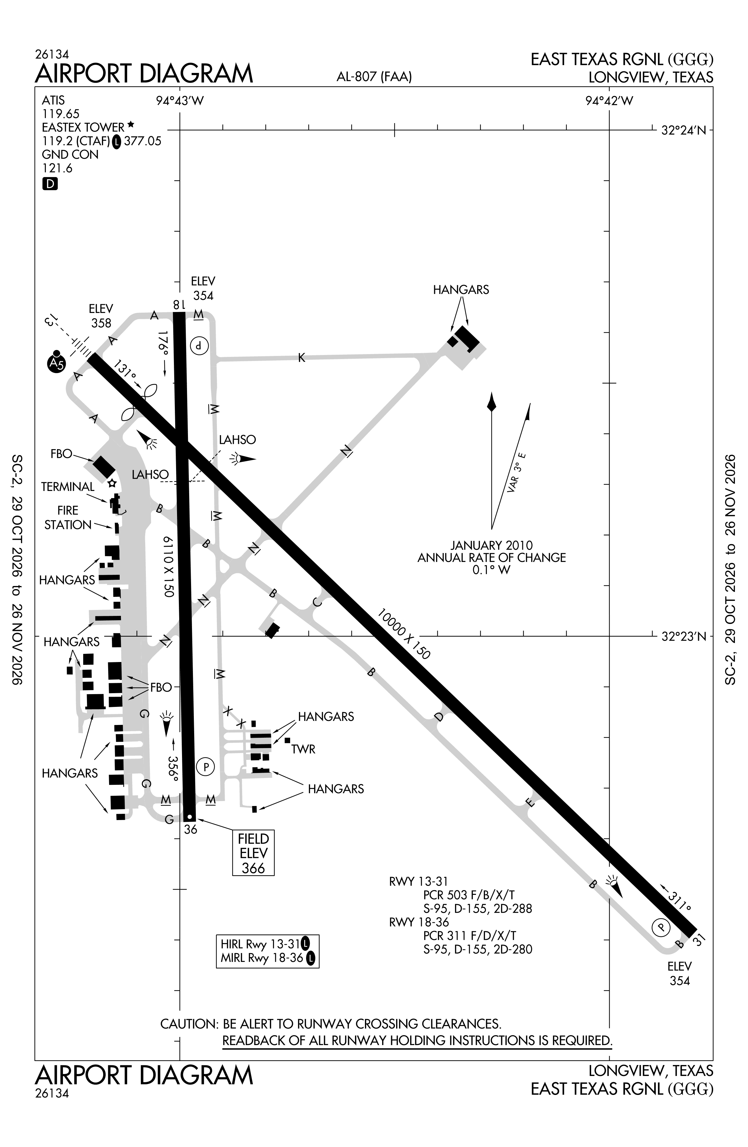
Official FAA PDF (effective Oct 29 to Nov 26)
FAA airport diagram, cycle 2611, effective Oct 29 to Nov 26, 2026. Reference only, not for navigation.
FBOs and services
FBOs
- KRS Jet Center
FBO locations from OpenStreetMap, community-maintained and may be out of date. Call ahead to confirm services and hours.
Not listed? The FBO may not be in OpenStreetMap. Send a correction.
Data © OpenStreetMap contributors (ODbL), as of Nov 3, 2026.
Related
- Interactive NOTAM search for KGGG (category filters, maps, share links and a NOTAM decoder)
- East Texas Regional Airport: codes, map and current weather
- GGG weather and runway winds (METAR and TAF in plain English)
- Flights at GGG now
- NOTAMs for other US airports
More NOTAMs in Texas
Times are UTC (Z). Plain-English explanations are generated by cwsi.net from the NOTAM abbreviations and may simplify; the original NOTAM text is authoritative. NOTAMs come from the FAA NOTAM Management Service; cwsi.net refreshes its copy every 3 minutes. cwsi.net is not affiliated with the FAA: always confirm NOTAMs through official sources (a standard briefing or FAA NOTAM Search) before flight.