BRO NOTAMs
Brownsville/South Padre Island International Airport, Brownsville, TX · KBRO
Brownsville/South Padre Island International Airport in Brownsville, Texas (IATA BRO, ICAO KBRO) has 22 current NOTAMs (Notices to Air Missions): 21 in effect now and 1 starting later. By category: taxiways (10), airspace (5) and navaids (3). The list comes from the FAA NOTAM Management Service, refreshed by cwsi.net every few minutes; each NOTAM shows its number, category, start and end time in UTC, and a plain-English reading.
- Taxiway10
- Airspace5
- Navaid3
- Runway3
- Communications1
In effect now (21)
AIRSPACE UAS WI AN AREA DEFINED AS 1NM RADIUS OF 255733.20N0971812W (7.4NM ENE BRO) SFC-1000FT AGL 2611051300-2611052200
NAV ILS RWY 13 GP U/S 2610312026-2611262000
RWY 36 VASI U/S 2610310021-2611302200
RWY 18 PAPI U/S 2610310020-2611302200
TWY H BTN RWY 18/36 AND TWY J CLSD 2610231758-2612042100
TWY D HLDG PSN SIGN EAST SIDE FOR RWY 18/36 LGT U/S 2610231801-2612042100
TWY H BTN RWY 18/36 AND TWY B CLSD 2610231801-2612042100
TWY A CLSD 2610231800-2612042100
TWY B BTN TWY F AND APCH END RWY 36 CLSD 2610231759-2612042100
TWY F HLDG PSN SIGN FOR RWY 18/36 LGT U/S 2610231757-2612042100
TWY D HLDG PSN SIGN WEST SIDE FOR RWY 18/36 LGT U/S 2610231756-2612042100
TWY B BTN APCH END RWY 13 AND APCH END RWY 18 CLSD 2610231756-2612042100
TWY F CLSD 2610231755-2612042100
RWY 18/36 CLSD 2610231753-2612042200
AIRSPACE UAS WI AN AREA DEFINED AS 255623N0972001W (5.3NM NE BRO) TO 255748N0972043W (5.7NM NE BRO) TO 260219N0970919W (16.8NM NE BRO) TO 255758N0970844W (16NM ENE BRO) TO 255703N0971133W (5.7NM NE BRO) TO 255731N0971231W (12.4NM ENE BRO) TO 255721N0971352W (11.5NM ENE BRO) TO 255545N0971709W (7.6NM ENE BRO) TO 255601N0971847W (7.1NM ENE BRO) TO 255458N0972016W (5NM ESE BRO) TO POINT OF ORIGIN SFC-400FT AGL 2610101646-2701122359
AIRSPACE UAS WI AN AREA DEFINED AS 5NM RADIUS OF 260127N0972943W (7.3NM NW BRO) SFC-400FT AGL 2610101645-2701122359
AIRSPACE UAS WI AN AREA DEFINED AS 260204N0973512W (11.4NM NW BRO) TO 255702N0972938W (4NM NW BRO) TO 255612N0973002W (4.3NM WNW BRO) TO 255516N0973012W (4.1NM WNW BRO) TO 255340N0973006W (4.2NM WSW BRO) TO 255315N0973117W (4.1NM WSW BRO) TO 255423N0973212W (5.8 NM W BRO) TO 255528N0973213W (5.7NM WNW BRO) TO 255551N0973320W (6.7NM WNW BRO) TO 255548N0973511W (8.4 NM WNW BRO) TO 255623N0973411W (7.8NM WNW BRO) TO 255657N0973423W (7.8NM WNW BRO) TO 255647N0973458W (7.8NM WNW BRO) TO 255733N0973522W (9NM WNW BRO) TO 255715N0973615W (9.7NM WNW BRO) TO 255816N0973648W (10.1NM WNW BRO) TO 255838N0973718W (11NM WNW BRO) TO POINT OF ORIGIN SFC-400FT AGL 2610101644-2701122359
COM REMOTE COM OUTLET 122.3 U/S 2609301841-2612312200EST
NAV VORTAC NOT MNT 2609161114-2704282000EST
NAV ILS RWY 13 OM U/S 2605061425-PERM
TWY G LOCATION MARKINGS NOT STD 2208251402-PERM
Starting later (1)
AIRSPACE PYROTECHNIC DEMONSTRATION WI AN AREA DEFINED AS 1NM RADIUS OF 260603N0971013W (10.4NM ESE PIL) SFC-400FT AGL 2611080130-2611080230
Airport diagram
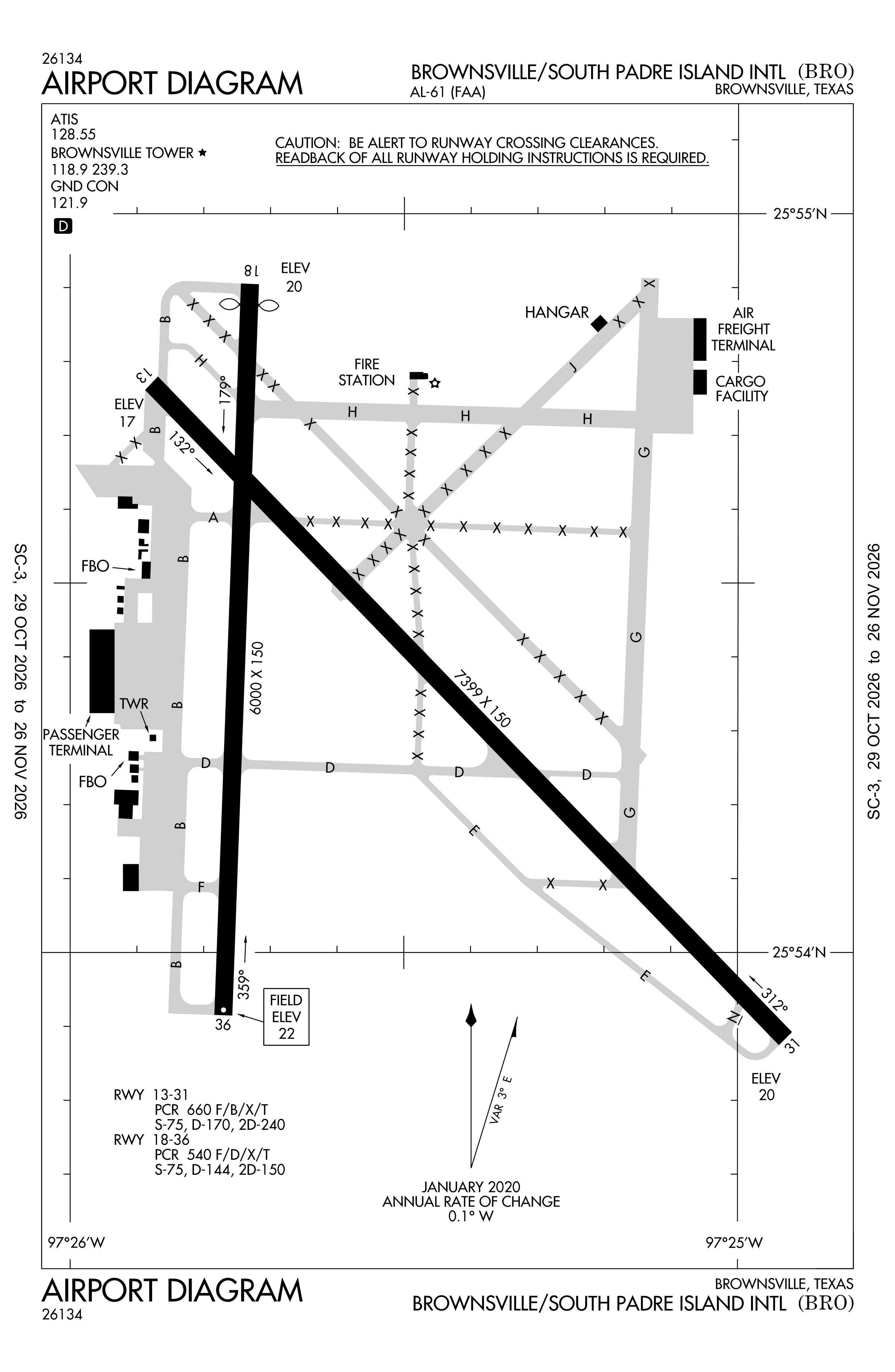
Official FAA PDF (effective Oct 29 to Nov 26)
FAA airport diagram, cycle 2611, effective Oct 29 to Nov 26, 2026. Reference only, not for navigation.
FBOs and services
FBOs
No FBOs are listed in OpenStreetMap for this airport.
Not listed? The FBO may not be in OpenStreetMap. Send a correction.
Data © OpenStreetMap contributors (ODbL), as of Nov 3, 2026.
Related
- Interactive NOTAM search for KBRO (category filters, maps, share links and a NOTAM decoder)
- Brownsville/South Padre Island International Airport: codes, map and current weather
- BRO weather and runway winds (METAR and TAF in plain English)
- Flights at BRO now
- NOTAMs for other US airports
More NOTAMs in Texas
Times are UTC (Z). Plain-English explanations are generated by cwsi.net from the NOTAM abbreviations and may simplify; the original NOTAM text is authoritative. NOTAMs come from the FAA NOTAM Management Service; cwsi.net refreshes its copy every 3 minutes. cwsi.net is not affiliated with the FAA: always confirm NOTAMs through official sources (a standard briefing or FAA NOTAM Search) before flight.