AMA NOTAMs
Rick Husband Amarillo International Airport, Amarillo, TX · KAMA
Rick Husband Amarillo International Airport in Amarillo, Texas (IATA AMA, ICAO KAMA) has 22 current NOTAMs (Notices to Air Missions): 12 in effect now and 10 starting later. By category: taxiways (8), procedures (5) and obstacles (3). The list comes from the FAA NOTAM Management Service, refreshed by cwsi.net every few minutes; each NOTAM shows its number, category, start and end time in UTC, and a plain-English reading.
- Taxiway8
- Procedures5
- Obstacle3
- Runway2
- Aerodrome1
- Airspace1
- Apron1
- Navaid1
In effect now (12)
AIRSPACE UAS WI AN AREA DEFINED AS 3NM RADIUS OF AMA SFC-300FT AGL MON-FRI 1400-2300 2611161400-2611242300
AD AP WINDCONE PRI LGT U/S 2610301049-2611302200
OBST WIND TURBINE FARM WI AN AREA DEFINED AS 3NM RADIUS OF 352326N1013504W (16.7NM NE AMA) 3929FT (400FT AGL) NOT LGTD 2610220507-2611222300
APRON GA RAMP INTERNATIONAL AEROSPACE COATINGS HANGAR 6 CL MARKINGS NOT MARKED 2610071200-2611302300
IAP RICK HUSBAND AMARILLO INTL, AMARILLO, TX. VOR RWY 13, ORIG-B... CIRCLING CAT C VISIBILITY 1 3/4, CIRCLING CAT D VISIBILITY 2 1/4. 2609282029-2809282029EST
NAV ILS RWY 04 OM U/S 2608061524-2802212111EST
IAP U.S. DOD RICK HUSBAND AMARILLO INTL, AMARILLO, TX. HI - VOR OR TACAN RWY 4, AMDT 1A... MSA FROM PNH VORTAC 360 CW 180 MINIMUM ALTITUDE 5300. 2603201415-2803201415EST
OBST CRANE (ASN 2025-ASW-14157-OE) 351127N1014229W (1.51NM N AMA) 3679FT (80FT AGL) FLAGGED 2601082307-2707072200
OBST CRANE (ASN 2025-ASW-14830-OE) 351127N1014229W (1.47NM S AMA) 3753FT (153FT AGL) FLAGGED 2601082244-2707072200
IAP RICK HUSBAND AMARILLO INTL, AMARILLO, TX. LDA RWY 22, AMDT 1D... AUTOPILOT COUPLED APPROACH UNUSABLE BELOW 3762 MSL.. 2505221820-2705221820EST
IAP U.S. DOD RICK HUSBAND AMARILLO INTL, AMARILLO, TX. HI - VOR OR TACAN RWY 13, ORIG-B... S-13 MDA 4120/HAT 517 ALL CATS. VISIBILITY ALL CATS 1 3/8. WITH BORGER ALTIMETER SETTING: S-13 MDA 4280/HAT 677 ALL CATS. VISIBILITY ALL CATS 1 3/4. VDP AT PNH VORTAC 1.17 DME; DISTANCE VDP TO THLD 1.45 NM. CHANGE MINIMUM HOLDING ALTITUDE AT SIDER (IAF) PNH R-247/20 DME FROM 14000 TO AT OR ABOVE FL 180. MSA FROM PNH VORTAC 360 CW 180 MINIMUM ALTITUDE 5300. 2504021330-2704021330EST
IAP RICK HUSBAND AMARILLO INTL, AMARILLO, TX. VOR RWY 13, ORIG-B... VOR RWY 22, AMDT 1A... VOR RWY 31, ORIG-B... MSA FROM PNH VORTAC 360 CW 180 MINIMUM ALTITUDE 5300. 2503311649-2704011649EST
Starting later (10)
TWY C CLSD 2611172000-2611172100
TWY P BTN TWY J AND TWY P4 CLSD 2611172000-2611172100
TWY J CLSD 2611171800-2611171900
TWY P3 BTN TWY P AND GA RAMP CLSD 2611171800-2611171900
TWY P BTN TWY P3 AND TWY J CLSD 2611171800-2611171900
TWY P BTN TWY P2 AND TWY P3 CLSD 2611171600-2611171800
RWY 31 PAPI U/S 2611181400-2611182130
TWY P BTN TWY P1 AND TWY P2 CLSD 2611171400-2611171600
TWY K, K1, K2, K3, K4, K5, K6 CLSD 2611181400-2611182300
RWY 13/31 CLSD 2611181400-2611182300
Airport diagram

FAA chart (PNG) Official FAA PDF (effective Oct 29 to Nov 26)
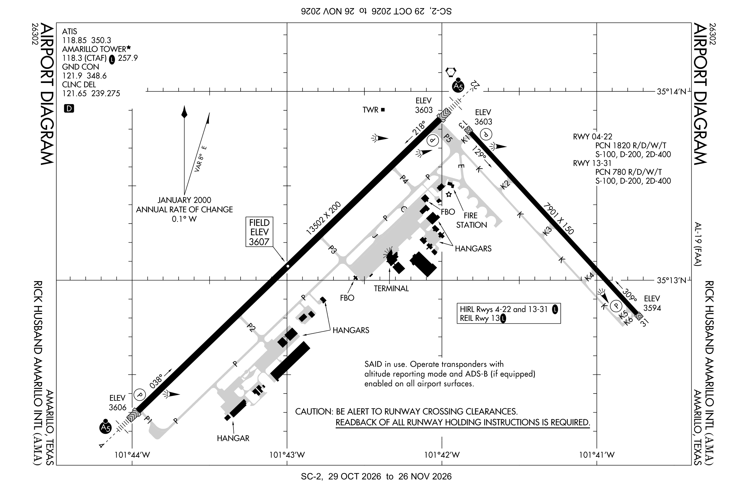
Redrawn by cwsi.net from the FAA airport diagram, cycle 2611, effective Oct 29 to Nov 26, 2026, and OpenStreetMap. Reference only, not for navigation.
FBOs and services
FBOs
 Signature Amarillo10610 American Drive, Amarillo, TX 79111+1 806-335-2806Hours: 24 hours a day/7 days a weekUNICOM 122.95ARINC 129.87Signature page
FBO details may be out of date. Call ahead to confirm services and hours.
Not listed? Send a correction.
As of Nov 5, 2026.
Related
- Interactive NOTAM search for KAMA (category filters, maps, share links and a NOTAM decoder)
- Rick Husband Amarillo International Airport: codes, map and current weather
- AMA weather and runway winds (METAR and TAF in plain English)
- Flights at AMA now
- NOTAMs for other US airports
More NOTAMs in Texas
Times are UTC (Z). Plain-English explanations are generated by cwsi.net from the NOTAM abbreviations and may simplify; the original NOTAM text is authoritative. NOTAMs come from the FAA NOTAM Management Service; cwsi.net refreshes its copy every 3 minutes. cwsi.net is not affiliated with the FAA: always confirm NOTAMs through official sources (a standard briefing or FAA NOTAM Search) before flight.