GRK NOTAMs
Robert Gray Army Airfield, Killeen, TX · KGRK
Robert Gray Army Airfield in Killeen, Texas (IATA GRK, ICAO KGRK) has 21 current NOTAMs (Notices to Air Missions): 18 in effect now and 3 starting later. By category: obstacles (4), taxiways (3) and aprons (2). The list comes from the FAA NOTAM Management Service, refreshed by cwsi.net every few minutes; each NOTAM shows its number, category, start and end time in UTC, and a plain-English reading.
- Obstacle4
- Taxiway3
- Apron2
- Navaid2
- Airspace1
- Procedures1
- Other8
In effect now (18)
M1136/26 NOTAMN Q) ZHU/QFAXX/IV/NBO/A/000/999/3104N09749W005 A) KGRK B) 2611041333 C) 2701292100 E) MILITARY ADACG OPERATING HOURS M-F; OUTBOUND PAX OR CARGO ACFT MUST ARR M-F BTN 1330Z-1900Z (0730-1300L CT) AND DEP NLT 2200Z (1600L CT). WORKING MOG OF 1. POC: ADACG 254-288-1118/254-287-4873
M1134/26 NOTAMN Q) ZHU/QFAXX/IV/NBO/A/000/999/3104N09749W005 A) KGRK B) 2611041330 C) 2701292100 E) MILITARY ADACG OPERATING HOURS M-F; INBOUND PAX OR CARGO ACFT MUST ARR M-F BTN 1330Z-2000Z (0730L CT - 1400L CT). WORKING MOG OF 1. POC: ADACG 254-288-1118/254-287-4873
M1128/26 NOTAMN Q) ZHU/QMRLT/IV/NBO/A/000/999/3104N09749W005 A) KGRK B) 2611021408 C) 2611152200 E) RWY 15/33 STOP AND GO UNAVAILABLE
M1126/26 NOTAMN Q) ZHU/QMRLT/IV/NBO/A/000/999/3104N09749W005 A) KGRK B) 2611021406 C) 2611152200 E) RWY 15/33 TGL UNAVAILABLE
OBST TOWER LGT (ASR 1052283) 310613.00N0974742.00W (2.8NM NE GRK) 1186FT (201FT AGL) U/S 2610271313-2612111913
OBST TOWER LGT (ASR 1245507) 310300.60N0975142.20W (2NM SW GRK) 1506FT (308FT AGL) U/S 2610230639-2612070639
M1059/26 NOTAMN Q) ZHU/QFAXX/IV/NBO/A/000/999/3104N09749W005 A) KGRK KHLR B) 2610110738 C) 2611101400 E) NO FLY AREA LASER FOR FORT HOOD AIRCRAFT REMAIN 3KM CLEAR OF INCIDENT AREA N310488W0971971 FROM SURFACE TO 5,000 MSL
AIRSPACE UAS WI AN AREA DEFINED AS 5NM RADIUS OF GRK SFC-2500FT AGL 2610051326-2701041400
TWY A SOUTH 4200FT CLSD 2609251524-2612182100
TWY F CLSD 2609251522-2612182100
APRON HAZARDOUS CARGO RAMP CLSD 2609251522-2612182100
TWY E BTN TWY A AND RWY 15/33 CLSD 2609251521-2612182100
M1004/26 NOTAMN Q) ZHU/QMRLT/IV/NBO/A/000/999/3104N09749W005 A) KGRK B) 2609251517 C) 2612182100 E) RWY 15 ACFT LDG REQUIRING WEST SIDE ACCESS THAT PASS TWY C MUST EXECUTE 180 DEG TURN AND BACK-TAXI. HEAVY ACFT MUST EXECUTE 180 ON CONCRETE PORTION SOUTH 1000FT
APRON SOUTH RAMP S 444FT CLSD 2609181945-2612182100
M0937/26 NOTAMN Q) ZHU/QFALT/IV/NBO/A/000/999/3104N09749W005 A) KGRK B) 2609111320 C) 2612042100 E) SOUTH RAMP PRKG MOG OF 2
M0939/26 NOTAMN Q) ZHU/QFAXX/IV/NBO/A/000/999/3104N09749W005 A) KGRK B) 2609111320 C) 2612042100 E) AERODROME NO RON OR EXTENDED STAY ON THE SOUTH RAMP.
OBST ANTENNA (ASN UNKNOWN) 310202N0974848W (2.14NM SE GRK) 957FT (80FT AGL) NOT LGTD 2609031828-2612012359
OBST TOWER LGT (ASR 1234998) 310826.80N0974732.10W (4.8NM NNE GRK) 1143.0FT (193.9FT AGL) U/S 2609010129-2611300229
Starting later (3)
SID ROBERT GRAY AAF, FORT HOOD (KILLEEN), TX. LAMPS NINE DEPARTURE... STONEWALL TRANSITION NA EXCEPT FOR ACFT EQUIPPED WITH SUITABLE RNAV SYSTEM WITH GPS, STV VORTAC OUT OF SERVICE. 2611051500-2611051930EST
NAV ILS RWY 15 SFC-1215FT UNUSABLE BEYOND .5 NM 2611051500-2611052200
NAV ILS RWY 33 UNUSABLE OTS FOR MAINTENANCE 2611051500-2611052200
Airport diagram
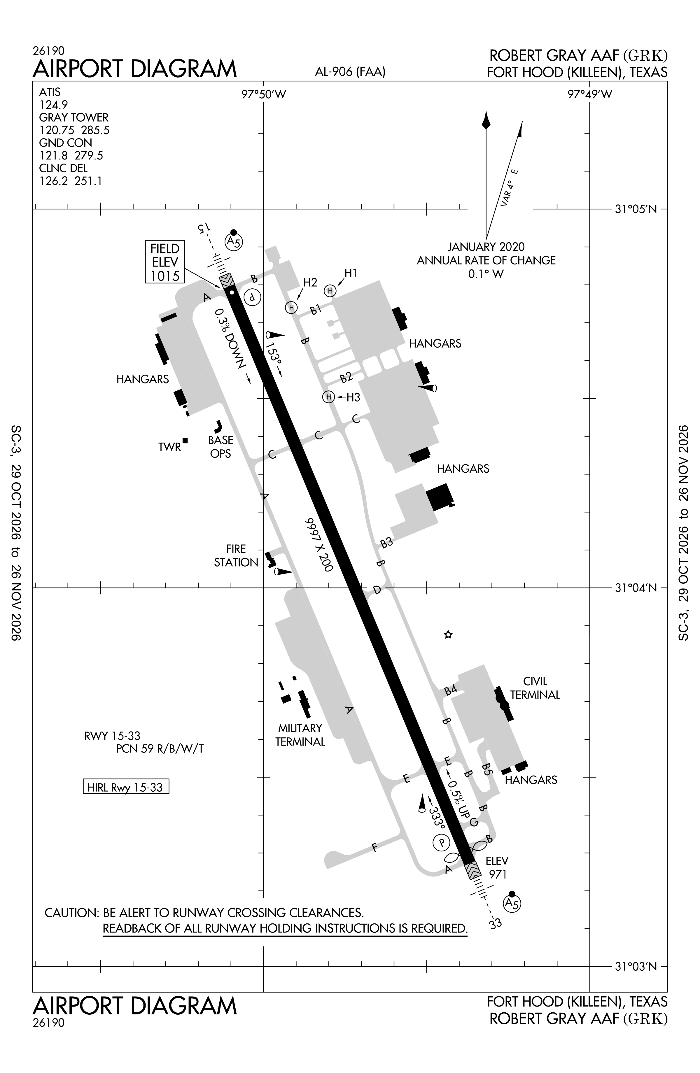
Official FAA PDF (effective Oct 29 to Nov 26)
FAA airport diagram, cycle 2611, effective Oct 29 to Nov 26, 2026. Reference only, not for navigation.
FBOs and services
FBOs
No FBOs are listed in OpenStreetMap for this airport.
Not listed? The FBO may not be in OpenStreetMap. Send a correction.
Data © OpenStreetMap contributors (ODbL), as of Nov 3, 2026.
Related
- Interactive NOTAM search for KGRK (category filters, maps, share links and a NOTAM decoder)
- Robert Gray Army Airfield: codes, map and current weather
- GRK weather and runway winds (METAR and TAF in plain English)
- Flights at GRK now
- NOTAMs for other US airports
More NOTAMs in Texas
Times are UTC (Z). Plain-English explanations are generated by cwsi.net from the NOTAM abbreviations and may simplify; the original NOTAM text is authoritative. NOTAMs come from the FAA NOTAM Management Service; cwsi.net refreshes its copy every 3 minutes. cwsi.net is not affiliated with the FAA: always confirm NOTAMs through official sources (a standard briefing or FAA NOTAM Search) before flight.