CRP NOTAMs
Corpus Christi International Airport, Corpus Christi, TX · KCRP
Corpus Christi International Airport in Corpus Christi, Texas (IATA CRP, ICAO KCRP) has 28 current NOTAMs (Notices to Air Missions): 28 in effect now and 0 starting later. By category: obstacles (19), procedures (5) and airspace (2). The list comes from the FAA NOTAM Management Service, refreshed by cwsi.net every few minutes; each NOTAM shows its number, category, start and end time in UTC, and a plain-English reading.
- Obstacle19
- Procedures5
- Airspace2
- Runway1
- Taxiway1
In effect now (28)
OBST TOWER LGT (ASN 2019-ASW-6104-OE) 274651N0972756W (2.0NM ENE CRP) 412FT (370FT AGL) U/S 2611131625-2612262359
OBST TOWER LGT (ASR 1050123) 274802.00N0972845.00W (2.1NM NE CRP) 268.7FT (221.8FT AGL) U/S 2611112157-2702112359
TWY B LOCATION SIGN BTN TWY E AND TWY B3 LGT U/S 2611100650-2611232300
RWY 31 6000FT DIST REMAINING SIGN LGT U/S 2611051158-2612052300
OBST TOWER LGT (ASN 2013-ASW-7221-OE) 275009N0973004W (3.8NM NE CRP) 285FT (274FT AGL) U/S 2611030622-2702032359
OBST TOWER LGT (ASN 2013-ASW-7220-OE) 274959N0973012W (3.7NM N CRP) 287FT (280FT AGL) U/S 2611030621-2702032359
OBST TOWER LGT (ASR 1211244) 274611.10N0972655.90W (2.9NM E CRP) 475.7FT (434.7FT AGL) U/S 2610211030-2701191130
AIRSPACE UAS WI AN AREA DEFINED AS 3NM RADIUS OF 274144N0972224W (4.1NM SE NGW) SFC-200FT AGL 2610191922-2612312359
IAP CORPUS CHRISTI INTL, CORPUS CHRISTI, TX. RNAV (GPS) Y RWY 31, AMDT 4A... LNAV/VNAV DA 416/HAT 373 ALL CATS. CIRCLING CAT A MDA 560/HAA 514. FOR INOP ALS, INCREASE LNAV/VNAV ALL CATS VISIBILITY TO 1 SM, REST OF NOTE UNCHANGED. TEMPORARY CRANE, 205 MSL, 1786FT SW OF RWY 31 (2023-ASW-8286-NRA). 2607272104-2703082355EST
IAP CORPUS CHRISTI INTL, CORPUS CHRISTI, TX. RNAV (RNP) Z RWY 31, AMDT 1A... RNP 0.14 DA 416/HAT 373 ALL CATS. VIS 5/8 ALL CATS. FOR INOP MALSR, INCREASE RNP 0.14 ALL CATS VISIBILITY TO 1 SM. TEMPORARY CRANE, 205 MSL, 1786FT SW OF RWY 31 (2023-ASW-8286-NRA). 2607272103-2703082355EST
IAP CORPUS CHRISTI INTL, CORPUS CHRISTI, TX. RNAV (GPS) Y RWY 36, AMDT 3A... LNAV/VNAV DA 416 HAT 376 ALL CATS. VIS RVR 3500 ALL CATS. LNAV MDA 520/HAT 480 ALL CATS. VIS CATS C/D/E RVR 5000. CIRCLING CAT A MDA 560/HAA 514. FOR INOP ALS, INCREASE LPV CAT E VISIBILITY TO RVR 4000, LNAV/VNAV ALL CATS VISIBILITY TO RVR 5500 AND LNAV CATS C/D/E VISIBILITY TO 1 3/8 SM. TEMPORARY CRANE, 205 MSL, 2728FT SW OF RWY 36 (2023-ASW-8286-NRA). 2607272101-2703082355EST
IAP CORPUS CHRISTI INTL, CORPUS CHRISTI, TX. ILS OR LOC RWY 13, AMDT 28B... ILS OR LOC RWY 36, AMDT 14B... LOC RWY 31, AMDT 9A... RNAV (GPS) X RWY 31, ORIG-A... RNAV (GPS) Y RWY 13, AMDT 2B... CIRCLING CAT A MDA 560/HAA 514. TEMPORARY CRANE, 205 MSL, 4187FT SOUTH OF KCRP AIRPORT (2023-ASW-8286-NRA). 2607272058-2703082355EST
IAP CORPUS CHRISTI INTL, CORPUS CHRISTI, TX. RNAV (GPS) RWY 18, AMDT 2A... LPV DA 292/HAT 250, VISIBILITY 3/4. LNAV/VNAV VISIBILITY 3/4. LNAV VISIBILITY CATS A/B 3/4. 34:1 IS NOT CLEAR. RWY 18 HELICOPTER VISIBILITY REDUCTION BELOW 3/4 SM NOT AUTHORIZED. INOPERATIVE TABLE DOES NOT APPLY TO LPV. FOR INOPERATIVE ALS, INCREASE LNAV/VNAV VISIBILITY TO 7/8 SM, AND LNAV CATS C, D, AND E VISIBILITY TO 1 3/4 SM. 2607242005-2703052005EST
OBST TOWER LGT (ASR UNKNOWN) 274434.51N0972406.84W (5.9NM SE CRP) UNKNOWN (200FT AGL) U/S 2604041027-2703312359
OBST TOWER LGT (ASR UNKNOWN) 273723.30N0971552.45W (14.5NM SW RAS) UNKNOWN (200FT AGL) U/S 2604041026-2703312359
OBST TOWER LGT (ASR UNKNOWN) 273819.14N0971342.67W (12.6NM SW CRP) UNKNOWN (200FT AGL) U/S 2604041026-2703312359
OBST TOWER LGT (ASR UNKNOWN) 273723.30N0971322.91W (13.5NM SW RAS) UNKNOWN (200FT AGL) U/S 2604041025-2703312359
OBST TOWER LGT (ASR UNKNOWN) 273833.36N0971941.09W (12.9NM SE CRP) UNKNOWN (200FT AGL) U/S 2604041025-2703312359
OBST TOWER LGT (ASR UNKNOWN) 273732.05N0971144.02W (12.7NM SW RAS) UNKNOWN (200FT AGL) U/S 2604041025-2703312359
OBST TOWER LGT (ASR UNKNOWN) 273717.83N0972410.55W (10.7NM SE CRP) UNKNOWN (200FT AGL) U/S 2604041024-2703312359
OBST TOWER LGT (ASR UNKNOWN) 274117.56N0972352.00W (8.3NM SE CRP) UNKNOWN (200FT AGL) U/S 2604041023-2703312359
OBST TOWER LGT (ASR UNKNOWN) 274604.22N0972251.42W (7.1NM E CRP) UNKNOWN (200FT AGL) U/S 2604041023-2703312359
OBST TOWER LGT (ASR UNKNOWN) 275137.62N0973733.92W (5.7NM NE RBO) UNKNOWN (200FT AGL) U/S 2604041022-2703312359
OBST TOWER LGT (ASR UNKNOWN) 274135.09N0972406.84W (7.5NM SE CRP) UNKNOWN (200FT AGL) U/S 2604041021-2703312359
OBST TOWER LGT (ASR 1050122) 274952.00N0973236.00W (4.1NM NNW CRP) 347.4FT (287.7FT AGL) U/S 2603082115-2703012359
AIRSPACE UAS WI AN AREA DEFINED AS 2.15NM RADIUS OF 280013N0972327W (8.7NM ESE T69) SFC-225FT AGL 2512220404-2612312359
OBST POLE LGT (ASN 2020-ASW-5269-OE) 274041N0971831W (11.8NM ESE CRP) 110FT (100FT AGL) U/S 2202112128-PERM
OBST POLE LGT (ASN 2020-ASW-5268-OE) 274054N0971855W (11.4NM ESE CRP) 112FT (100FT AGL) U/S 2202112127-PERM
Airport diagram

FAA chart (PNG) Official FAA PDF (effective Oct 29 to Nov 26)
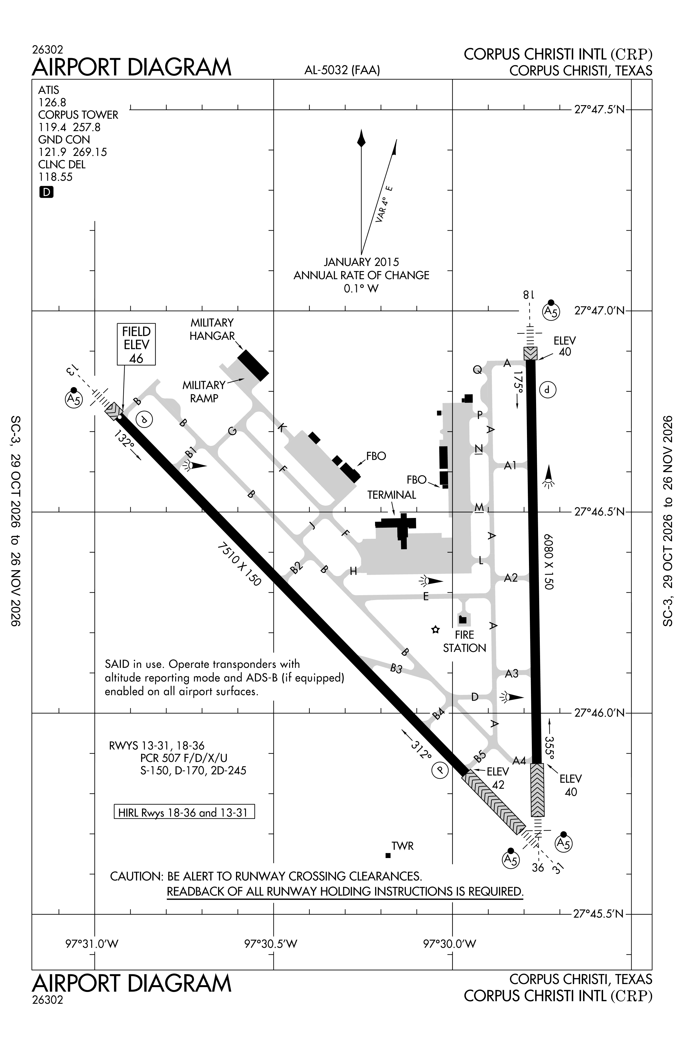
Redrawn by cwsi.net from the FAA airport diagram, cycle 2611, effective Oct 29 to Nov 26, 2026, and OpenStreetMap. Reference only, not for navigation.
FBOs and services
FBOs
 Atlantic Aviation Corpus Christi549 Pinson Drive, Corpus Christi, TX+1 361-289-1881Hours: Mon-Sun: 0500-2300Atlantic page
FBO details may be out of date. Call ahead to confirm services and hours.
Not listed? Send a correction.
As of Nov 5, 2026.
Related
- Interactive NOTAM search for KCRP (category filters, maps, share links and a NOTAM decoder)
- Corpus Christi International Airport: codes, map and current weather
- CRP weather and runway winds (METAR and TAF in plain English)
- Flights at CRP now
- NOTAMs for other US airports
More NOTAMs in Texas
Times are UTC (Z). Plain-English explanations are generated by cwsi.net from the NOTAM abbreviations and may simplify; the original NOTAM text is authoritative. NOTAMs come from the FAA NOTAM Management Service; cwsi.net refreshes its copy every 3 minutes. cwsi.net is not affiliated with the FAA: always confirm NOTAMs through official sources (a standard briefing or FAA NOTAM Search) before flight.