BPT NOTAMs
Jack Brooks Regional Airport, Beaumont, TX · KBPT
Jack Brooks Regional Airport in Beaumont, Texas (IATA BPT, ICAO KBPT) has 28 current NOTAMs (Notices to Air Missions): 28 in effect now and 0 starting later. By category: obstacles (20), navaids (2) and procedures (2). The list comes from the FAA NOTAM Management Service, refreshed by cwsi.net every few minutes; each NOTAM shows its number, category, start and end time in UTC, and a plain-English reading.
- Obstacle20
- Navaid2
- Procedures2
- Runway2
- Taxiway2
In effect now (28)
OBST TOWER LGT (ASR 1295790) 295416.80N0935809.30W (3.8NM SE BPT) 299.9FT (292.0FT AGL) U/S 2611032223-2612012359
OBST TOWER LGT (ASR 1284828) 295609.20N0940634.40W (4.8NM W BPT) 229.0FT (222.1FT AGL) U/S 2611030114-2703030114
IAP JACK BROOKS RGNL, BEAUMONT/PORT ARTHUR, TX. ILS OR LOC RWY 12, AMDT 24A... ALTERNATE MINIMUMS NA EXCEPT FOR ACFT EQUIPPED WITH SUITABLE RNAV SYSTEM WITH GPS, SBI VOR/DME UNMONITORED. 2610291513-2611052000EST
NAV DME NOT MNT 2610281339-2611062000EST
NAV ILS RWY 12 GP NOT MNT 2610231025-2706042000EST
OBST TOWER LGT (ASR 1055084) 295706.00N0935246.00W (7.4NM E BPT) 484.9FT (480.0FT AGL) U/S 2610081446-2701082359
OBST TOWER LGT (ASR 1055085) 295705.00N0935248.00W (7.4NM E BPT) 203.4FT (200.1FT AGL) U/S 2610081447-2701082359
OBST TOWER LGT (ASN 1999-ASW-2074-OE) 295711N0935311W (7.0NM E BPT) 323FT (316FT AGL) U/S 2610051842-2612312359
OBST TOWER LGT (ASN 1999-ASW-2073-OE) 295709N0935313W (7.0NM E BPT) 243FT (236FT AGL) U/S 2610051841-2612312235
OBST TOWER LGT (ASN 1999-ASW-2072-OE) 295714N0935305W (7.1NM E BPT) 217FT (210FT AGL) U/S 2610051840-2612312359
OBST TOWER LGT (ASN 2002-ASW-581-OE) 295716N0935315W (7.0NM E BPT) 219FT (211FT AGL) U/S 2610051839-2612312359
OBST TOWER LGT (ASN 2002-ASW-583-OE) 295717N0935314W (7.0NM E BPT) 276FT (268FT AGL) U/S 2610051840-2612312359
OBST TOWER LGT (ASN 2002-ASW-584-OE) 295719N0935312W (7.0NM E BPT) 259FT (251FT AGL) U/S 2610051838-2612312359
OBST STACK (ASN 2022-ASW-20391-OE) 300032N0940208W (2.6NM NNW BPT) 275FT (256FT AGL) NOT LGTD 2609281738-2701312359
OBST STACK LGT (ASN 2011-ASW-4519-OE) 295808N0935337W (6.8NM E BPT) 277FT (266FT AGL) NOT LGTD 2608170138-2611162359
OBST STACK LGT (ASN 1989-ASW-1249-OE) 295759N0935338W (7.2NM E BPT) 215FT (204FT AGL) NOT LGTD 2608170136-2611162359
OBST STACK LGT (ASN 2011-ASW-4504-OE) 295810N0935314W (7.1NM E BPT) 275FT (263FT AGL) U/S 2608170130-2611162359
OBST TOWER LGT (ASN 2011-ASW-4508-OE) 295756N0935308W (7.2NM E BPT) 397FT (385FT AGL) U/S 2608170129-2611162359
OBST TOWER LGT (ASN 1989-ASW-1247-OE) 295750N0935337W (7.2NM E BPT) 232FT (221FT AGL) U/S 2608170127-2611162359
OBST TOWER LGT (ASR 1027375) 295532.70N0941004.10W (7.9NM W BPT) 270.0FT (262.1FT AGL) U/S 2608141152-2611130400
IAP JACK BROOKS RGNL, BEAUMONT/PORT ARTHUR, TX. RNAV (GPS) RWY 34, AMDT 1A... HEVLO FIX MINIMUM ALTITUDE 660. TEMPORARY CRANE, 302 MSL, 4.34NM SOUTH OF RWY 34 (2025-ASW-13348-OE). 2607091817-2805152000EST
RWY 16 RWY END ID LGT U/S 2606292324-3001042000EST
OBST TOWER LGT (ASR UNKNOWN) 300420.77N0940333.52W (7.5NM NW BPT) 434FT (425FT AGL) U/S 2512291532-2612312359
OBST CRANE (ASN UNKNOWN) 295943N0940206W (2.3NM N BPT) UNKNOWN (203FT AGL) FLAGGED 2505141443-2812312200
OBST STACK LGT (ASN 2019-ASW-13324-OE) 300334N0940407W (6.9NM NNW BPT) 317FT (303FT AGL) U/S 2505072029-2705072359
TWY E BTN TWY D AND RWY 12/30 CLSD 2411071411-PERM
RWY 12 DECLARED DIST: TORA 6750FT TODA 6750FT ASDA 6507FT LDA 6507FT. 2301112103-PERM
TWY E BTN RWY 12/30 AND RWY 16/34 CLSD 2203311227-PERM
Airport diagram
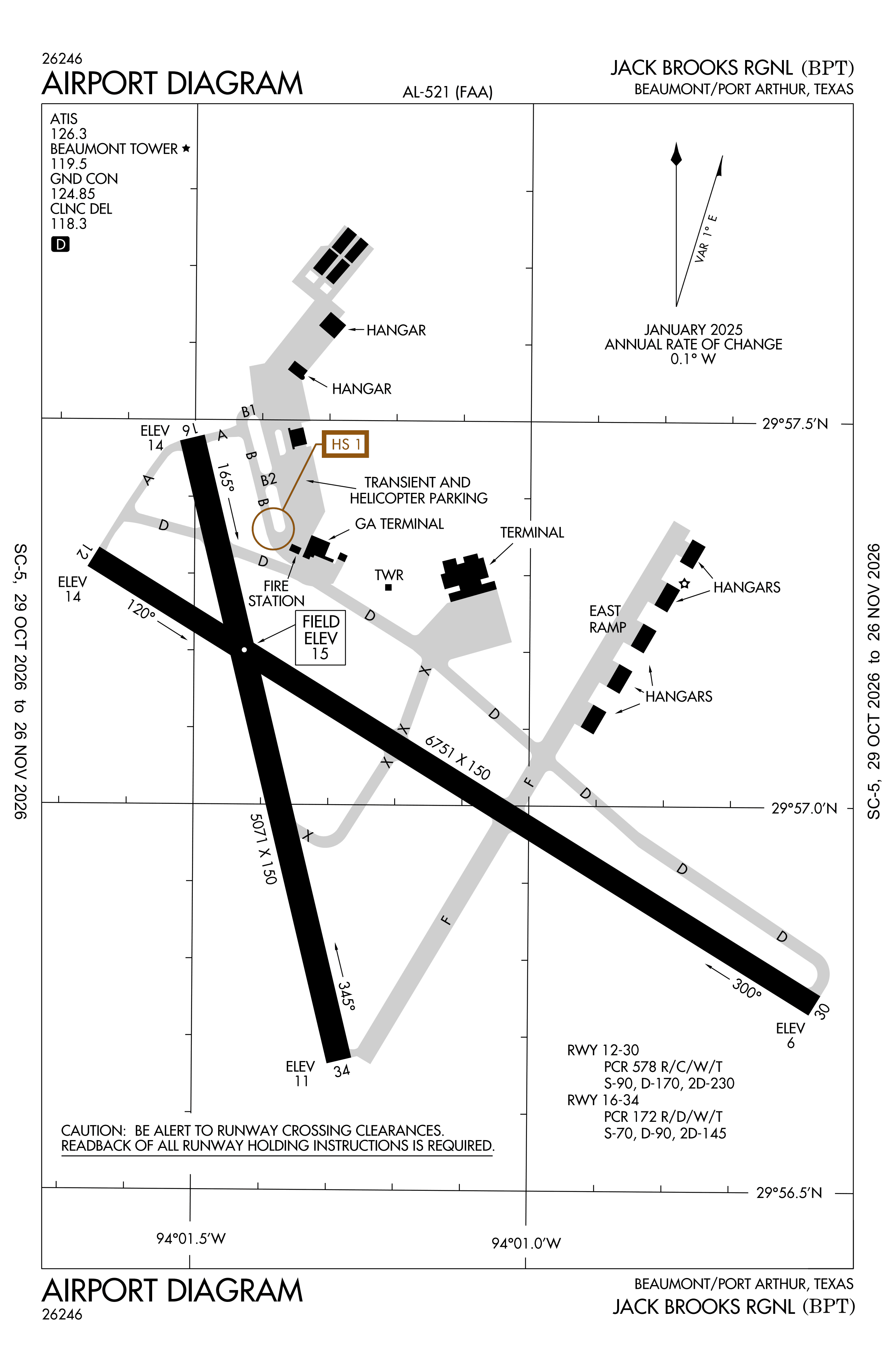
Official FAA PDF (effective Oct 29 to Nov 26)
FAA airport diagram, cycle 2611, effective Oct 29 to Nov 26, 2026. Reference only, not for navigation.
FBOs and services
FBOs
No FBOs are listed in OpenStreetMap for this airport.
Not listed? The FBO may not be in OpenStreetMap. Send a correction.
Data © OpenStreetMap contributors (ODbL), as of Nov 3, 2026.
Related
- Interactive NOTAM search for KBPT (category filters, maps, share links and a NOTAM decoder)
- Jack Brooks Regional Airport: codes, map and current weather
- BPT weather and runway winds (METAR and TAF in plain English)
- Flights at BPT now
- NOTAMs for other US airports
More NOTAMs in Texas
Times are UTC (Z). Plain-English explanations are generated by cwsi.net from the NOTAM abbreviations and may simplify; the original NOTAM text is authoritative. NOTAMs come from the FAA NOTAM Management Service; cwsi.net refreshes its copy every 3 minutes. cwsi.net is not affiliated with the FAA: always confirm NOTAMs through official sources (a standard briefing or FAA NOTAM Search) before flight.