CLL NOTAMs
Easterwood Field, College Station, TX · KCLL
Easterwood Field in College Station, Texas (IATA CLL, ICAO KCLL) has 13 current NOTAMs (Notices to Air Missions): 12 in effect now and 1 starting later. By category: taxiways (6), obstacles (3) and airspace (2). The list comes from the FAA NOTAM Management Service, refreshed by cwsi.net every few minutes; each NOTAM shows its number, category, start and end time in UTC, and a plain-English reading.
- Taxiway6
- Obstacle3
- Airspace2
- Procedures2
In effect now (12)
OBST TOWER LGT (ASR 1062866) 303835.00N0961953.00W (3.7NM NNE CLL) 652.9FT (364.2FT AGL) U/S 2611040830-2702042359
TWY A HLDG PSN SIGN SOUTHWEST SIDE FOR RWY 11/29 LGT U/S 2611011134-2611062300
TWY A HLDG PSN SIGN NORTHEAST SIDE FOR RWY 11/29 LGT U/S 2611011133-2611062300
TWY H HLDG PSN SIGN SOUTHEAST SIDE FOR RWY 11/29 LGT U/S 2610311027-2611062300
IAP EASTERWOOD FLD, COLLEGE STATION, TX. ILS OR LOC RWY 35, AMDT 15... LOC BC RWY 17, AMDT 8A... RNAV (GPS) RWY 11, AMDT 1D... RNAV (GPS) RWY 17, AMDT 1C... RNAV (GPS) RWY 29, AMDT 1B... RNAV (GPS) RWY 35, AMDT 1D... VOR OR TACAN RWY 11, AMDT 19F... VOR RWY 29, AMDT 14A... CIRCLING CAT A MDA 1000/HAA 679, CATS B/C MDA 1060/HAA 739. TEMPORARY CRANES, UP TO 742 MSL, BEGINNING 1.91 NM NE OF KCLL AIRPORT (2025-ASW-28 THRU 32-OE), TEMPORARY CRANES, UP TO 645 MSL BEGINNING 1.5 NM NE OF KCLL AIRPORT (2025-ASW-12862-OE), TEMPORARY CRANE, 526 MSL, 1.63 NM NORTH OF KCLL AIRPORT (2025-ASW-5924-NRA). 2610191506-2712011506EST
TWY G HLDG PSN MARKINGS FOR RWY 11/29 WEST SIDE NOT STD 2610121308-2612112300
OBST TOWER LGT (ASR 1002417) 303815.70N0962409.80W (3.6NM NW CLL) 564.0FT (229.0FT AGL) U/S 2609191013-2612181113
OBST TOWER LGT (ASR 1253226) 302835.70N0962557.90W (7.6NM SSW CLL) 620.1FT (400.3FT AGL) U/S 2609161931-2611242359
TWY H SFC PAINTED HLDG PSN SIGNS FOR APCH END RWY 35 NOT STD 2608311312-2611302200
TWY H HLDG PSN MARKINGS FOR APCH END RWY 35 NOT STD 2608312201-2611302200
AIRSPACE UAS WI AN AREA DEFINED AS 1.5NM RADIUS OF 83TX (6.9NM WNW CLL) SFC-400FT AGL DLY SR-SS 2606081123-2612272332
IAP EASTERWOOD FLD, COLLEGE STATION, TX. RNAV (GPS) RWY 35, AMDT 1D... LNAV/VNAV DA 619/HAT 308 ALL CATS. FOR INOPERATIVE ALS, INCREASE LPV CAT E VISIBILITY TO 3/4 SM, INCREASE LNAV/VNAV ALL CATS VISIBILITY TO 7/8 SM, INCREASE LNAV CAT E VISIBILITY TO 1 3/8 SM. TOWER, 458 MSL, 4419 FT EAST OF APCH END RWY 35 (48-183701 PERM OBSTACLE).. 2510021051-2705081051EST
Starting later (1)
AIRSPACE UAS WI AN AREA DEFINED AS 0.1NM RADIUS OF 303721.10N0961859W (3.2NM NE CLL) SFC-150FT AGL 2611051500-2611051700
Airport diagram
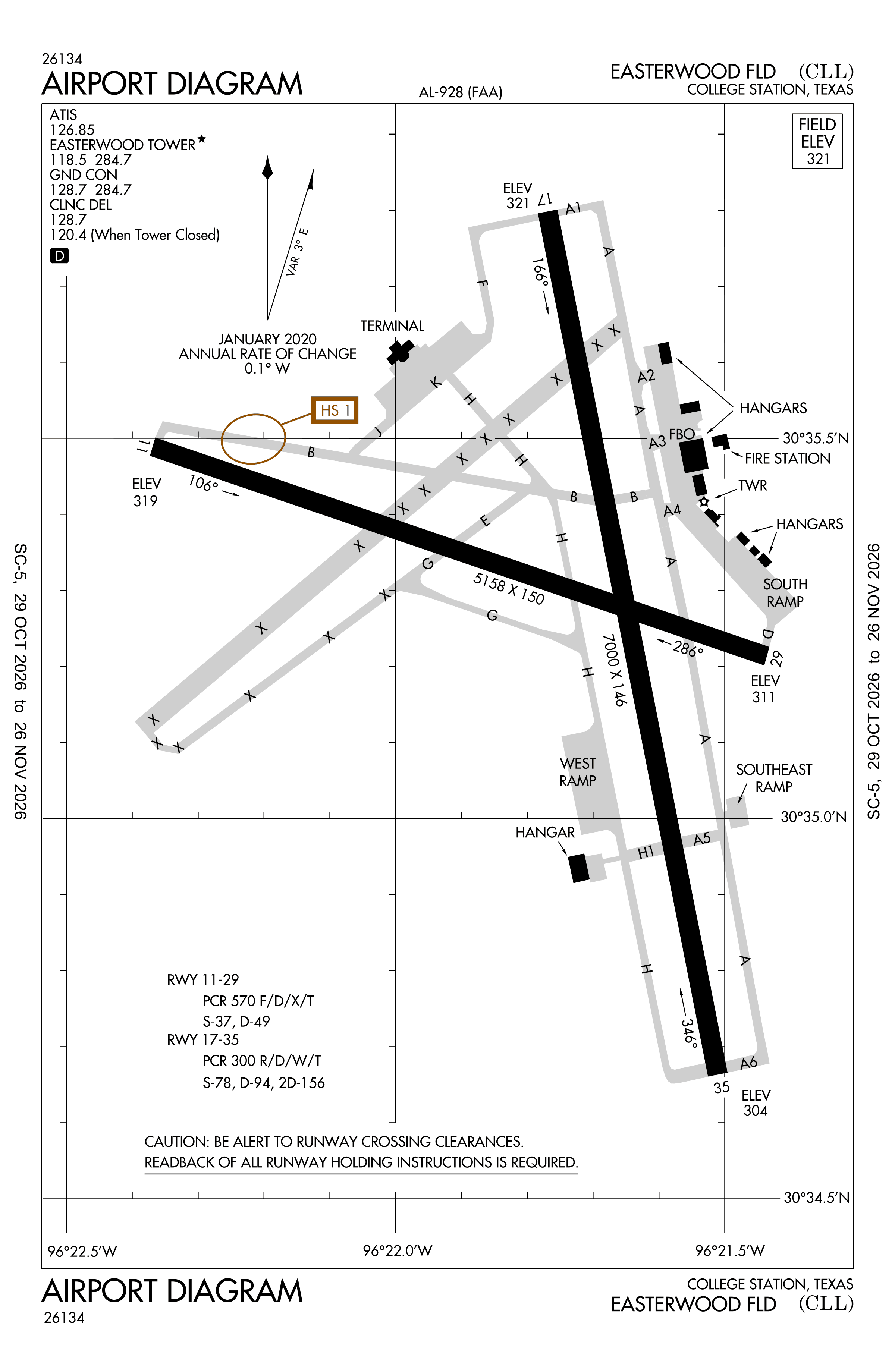
Official FAA PDF (effective Oct 29 to Nov 26)
FAA airport diagram, cycle 2611, effective Oct 29 to Nov 26, 2026. Reference only, not for navigation.
FBOs and services
FBOs
- Easterwood FBO and Hangar
- Easterwood FBO and Hanger
FBO locations from OpenStreetMap, community-maintained and may be out of date. Call ahead to confirm services and hours.
Not listed? The FBO may not be in OpenStreetMap. Send a correction.
Data © OpenStreetMap contributors (ODbL), as of Nov 3, 2026.
Related
- Interactive NOTAM search for KCLL (category filters, maps, share links and a NOTAM decoder)
- Easterwood Field: codes, map and current weather
- CLL weather and runway winds (METAR and TAF in plain English)
- Flights at CLL now
- NOTAMs for other US airports
More NOTAMs in Texas
Times are UTC (Z). Plain-English explanations are generated by cwsi.net from the NOTAM abbreviations and may simplify; the original NOTAM text is authoritative. NOTAMs come from the FAA NOTAM Management Service; cwsi.net refreshes its copy every 3 minutes. cwsi.net is not affiliated with the FAA: always confirm NOTAMs through official sources (a standard briefing or FAA NOTAM Search) before flight.