MAF NOTAMs
Midland International Air and Space Port, Midland, TX · KMAF
Midland International Air and Space Port in Midland, Texas (IATA MAF, ICAO KMAF) has 37 current NOTAMs (Notices to Air Missions): 34 in effect now and 3 starting later. By category: runways (14), airspace (7) and procedures (5). The list comes from the FAA NOTAM Management Service, refreshed by cwsi.net every few minutes; each NOTAM shows its number, category, start and end time in UTC, and a plain-English reading.
- Runway14
- Airspace7
- Procedures5
- Taxiway4
- Obstacle3
- Services2
- Apron1
- Navaid1
In effect now (34)
OBST CRANE (ASN UNKNOWN) 315526N1021211W (0.6NM S APCH END RWY 34L) UNKNOWN (65FT AGL) FLAGGED 2611161958-2611170400
RWY 10 FICON 5/5/5 100 PCT WET OBS AT 2611160721. 2611160721-2611170721
RWY 34R FICON 5/5/5 100 PCT WET OBS AT 2611160720. 2611160720-2611170720
RWY 04 FICON 5/5/5 100 PCT WET OBS AT 2611160720. 2611160720-2611170720
RWY 34L FICON 5/5/5 100 PCT WET OBS AT 2611160719. 2611160719-2611170719
APRON ALL FICON WET OBS AT 2611160718. 2611160718-2611170718
TWY ALL FICON WET OBS AT 2611160718. 2611160718-2611170718
IAP MIDLAND INTL AIR AND SPACE PORT, MIDLAND, TX. RNAV (GPS) RWY 34L, AMDT 1B... LNAV/VNAV DA 3248/HAT 390 ALL CATS. LNAV MDA 3340/HAT 482 ALL CATS, VIS CAT C/D 1 3/8. TEMPORARY RIGS, 3037 MSL, BEGINNING 4050FT SOUTHWEST OF RWY 34L (2025-ASW-4560/4562-OE). 2611051523-2711151523EST
AIRSPACE UAS WI AN AREA DEFINED AS 3NM RADIUS OF MAF270016 SFC-200FT AGL 2611021234-2612012100
RWY 34L 8000FT DIST REMAINING SIGN LGT U/S 2610312114-2612010600
RWY 16R 1000FT DIST REMAINING SIGN LGT U/S 2610312114-2612010600
RWY 22 HLDG PSN SIGN AT RWY 16R/34L LEFT SIDE LGT U/S 2610312113-2612010600
RWY 28 HLDG PSN SIGN AT RWY 16R/34L LEFT SIDE LGT U/S 2610312112-2612010600
TWY U CLSD 2610312113-2612010600
RWY 34L 7000FT DIST REMAINING SIGN LGT U/S 2610312111-2612010600
RWY 16R 3000FT DIST REMAINING SIGN LGT U/S 2610312111-2612010600
RWY 16R 2000FT DIST REMAINING SIGN LGT U/S 2610312112-2612010600
RWY 34L 6000FT DIST REMAINING SIGN LGT U/S 2610312109-2612010600
TWY W HLDG PSN SIGN FOR APCH END RWY 34R LGT U/S 2610312108-2612010600
OBST STACK (ASN UNKNOWN) 315629N1021239W (0.46NM SE APCH END RWY 10) UNKNOWN (50FT AGL) NOT LGTD 2610312108-2612010600
TWY C HLDG PSN SIGN SOUTHEAST SIDE FOR RWY 16L/34R LGT U/S 2610312107-2612010600
SVC PCL ALL U/S EXC MEDIUM INTST ON CONS 2609301818-2612312359
OBST TOWER LGT (ASR 1051408) 320551.40N1021722.50W (10.3NM NNW MAF) 4047.9FT (1133.9FT AGL) U/S 2609021258-2612010400
IAP MIDLAND INTL AIR AND SPACE PORT, MIDLAND, TX. ILS OR LOC RWY 10, AMDT 16C... S-LOC 10: DME REQUIRED EXCEPT FOR ACFT EQUIPPED WITH SUITABLE RNAV SYSTEM WITH GPS, FARLY (MA) LOM OUT OF SERVICE. 2606181517-2701281517EST
AIRSPACE UAS WI AN AREA DEFINED AS 4NM RADIUS OF 321230N1015748W (6.6NM WNW 63F) SFC-400FT AGL 2603311400-2703301400
AIRSPACE UAS WI AN AREA DEFINED AS 4NM RADIUS OF 320339N1014955W (7.3NM S 63F) SFC-400FT AGL 2603172000-2703161400
NAV ILS RWY 10 OM U/S 2603091143-2708302111EST
AIRSPACE UAS WI AN AREA DEFINED AS 4NM RADIUS OF 315708N1014931W (14.3NM NE 7T7) SFC-400FT AGL 2602272100-2702272100
AIRSPACE UAS WI AN AREA DEFINED AS 4NM RADIUS OF 314938N1015034W (12.5NM SE 7T7) SFC-400FT AGL 2512181500-2612181500
AIRSPACE UAS WI AN AREA DEFINED AS 4NM RADIUS OF 315015.90N1015758.40W (6.4NM E 7T7) SFC-400FT AGL 2512101500-2612101500
IAP MIDLAND INTL AIR AND SPACE PORT, MIDLAND, TX. RNAV (GPS) RWY 10, AMDT 2C... RNAV (GPS) RWY 16R, AMDT 1B... RNAV (GPS) RWY 22, AMDT 1C... RNAV (GPS) RWY 28, AMDT 2B... RNAV (GPS) RWY 34L, AMDT 1B... RNAV (GPS) RWY 4, AMDT 1C... CIRCLING MDA CATS C/D 3540/HAT 668. TEMPORARY CRANES STARTING AT 2.5NM NORTHEAST OF MAF AIRPORT, UP TO 300 AGL/3189 MSL (2025-ASW-11549-OE). 2512011636-2705042000EST
IAP U.S. DOD MIDLAND INTL AIR AND SPACE PORT, MIDLAND, TX. HI - VOR OR TACAN RWY 16R, AMDT 3... HI-VOR OR TACAN RWY 34L, AMDT 3... VOR OR TACAN RWY 16R, AMDT 23C... VOR OR TACAN RWY 34L, AMDT 10B... CIRCLING MDA CATS C/D 3540/HAT 668. TEMPORARY CRANES STARTING AT 2.5NM NORTHEAST OF MAF AIRPORT, UP TO 300 AGL/3189 MSL (2025-ASW-11549-OE). 2511242000-2705042000EST
IAP MIDLAND INTL AIR AND SPACE PORT, MIDLAND, TX. ILS OR LOC RWY 10, AMDT 16C... CIRCLING MDA CATS C/D 3540/HAT 668. USILE FIX MINIMUMS: CIRCLING MDA CATS C/D 3540/HAT 668. TEMPORARY CRANES STARTING AT 2.5NM NORTHEAST OF MAF AIRPORT, UP TO 300 AGL/3189 MSL (2025-ASW-11549-OE). 2511242000-2705042000EST
AIRSPACE UAS WI AN AREA DEFINED AS 4NM RADIUS OF 315215N1015441W (8.9NM W 7T7) SFC-400FT AGL 2511191500-2611191500
Starting later (3)
SVC ATIS U/S 2611171400-2611171500
RWY 16R/34L CLSD EXC XNG 2611171400-2611171700
RWY 16R/34L WIP GRASS CUTTING 2611171400-2611171700
Airport diagram

FAA chart (PNG) Official FAA PDF (effective Oct 29 to Nov 26)
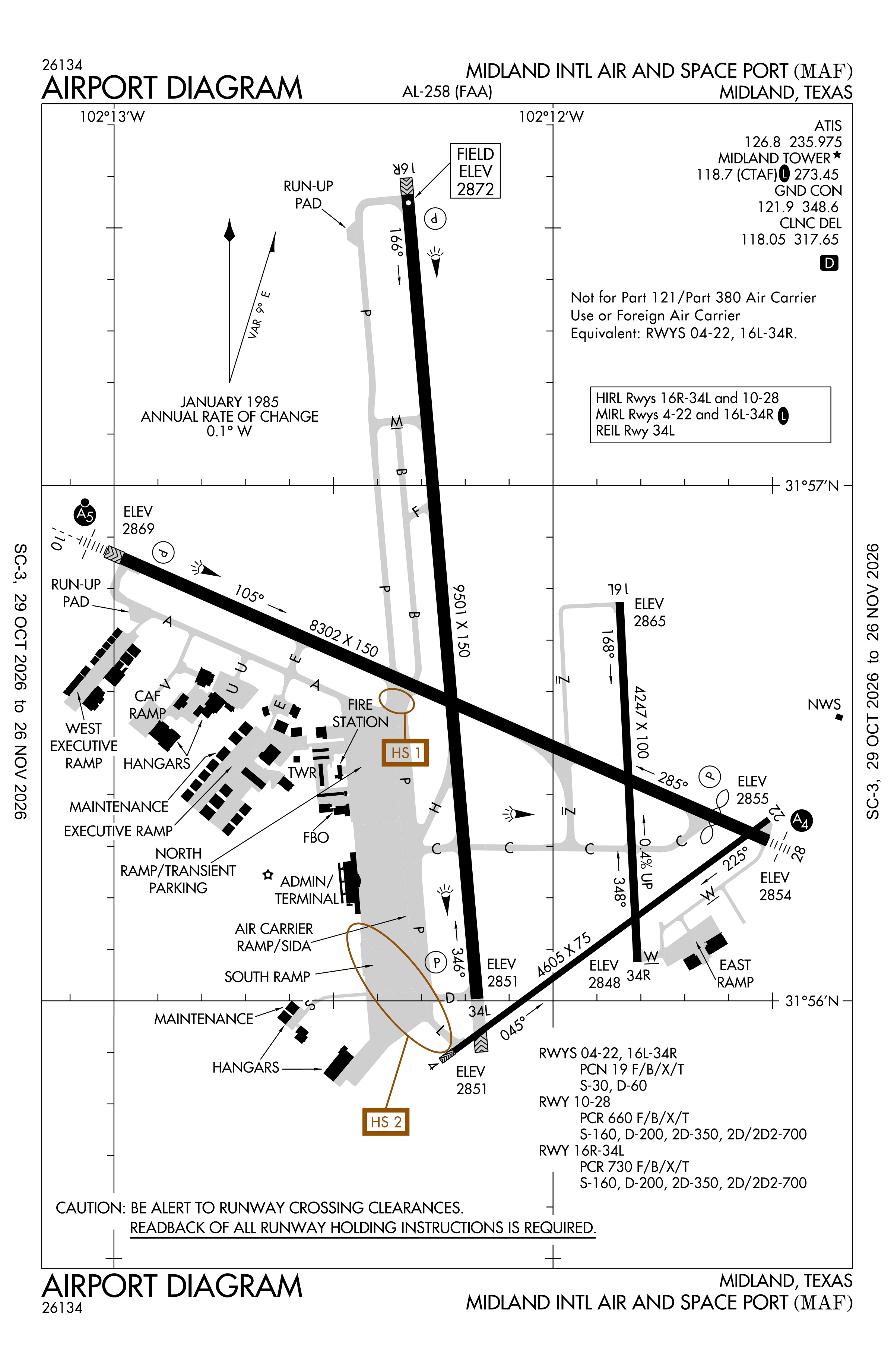
Redrawn by cwsi.net from the FAA airport diagram, cycle 2611, effective Oct 29 to Nov 26, 2026, and OpenStreetMap. Reference only, not for navigation.
FBOs and services
FBOs
 Signature Midland9500 North Service Road, Midland, TX 79711+1 432-563-2033Hours: 24 hours a day/7 days a weekARINC 122.95Signature page
FBO details may be out of date. Call ahead to confirm services and hours.
Not listed? Send a correction.
As of Nov 5, 2026.
Related
- Interactive NOTAM search for KMAF (category filters, maps, share links and a NOTAM decoder)
- Midland International Air and Space Port: codes, map and current weather
- MAF weather and runway winds (METAR and TAF in plain English)
- Flights at MAF now
- NOTAMs for other US airports
More NOTAMs in Texas
Times are UTC (Z). Plain-English explanations are generated by cwsi.net from the NOTAM abbreviations and may simplify; the original NOTAM text is authoritative. NOTAMs come from the FAA NOTAM Management Service; cwsi.net refreshes its copy every 3 minutes. cwsi.net is not affiliated with the FAA: always confirm NOTAMs through official sources (a standard briefing or FAA NOTAM Search) before flight.