SHV NOTAMs
Shreveport Regional Airport, Shreveport, LA · KSHV
Shreveport Regional Airport in Shreveport, Louisiana (IATA SHV, ICAO KSHV) has 17 current NOTAMs (Notices to Air Missions): 16 in effect now and 1 starting later. By category: runways (8), obstacles (6) and aerodromes (1). The list comes from the FAA NOTAM Management Service, refreshed by cwsi.net every few minutes; each NOTAM shows its number, category, start and end time in UTC, and a plain-English reading.
- Runway8
- Obstacle6
- Aerodrome1
- Navaid1
- Taxiway1
In effect now (16)
OBST TOWER LGT (ASR 1205585) 322348.20N0934828.20W (3.1NM SSE SHV) 449.1FT (245.7FT AGL) U/S 2611042213-2701132359
OBST TOWER LGT (ASR 1316021) 323414.60N0935507.00W (8.8NM NW SHV) 607FT (361FT AGL) U/S 2611041641-2612191641
OBST TOWER LGT (ASR 1060315) 322702.70N0935246.40W (2.7NM W SHV) 550.5FT (286.7FT AGL) U/S 2611040552-2703040552
NAV ILS RWY 32 U/S 2611032114-2611071400EST
RWY 14 SEQUENCED FLG LGT U/S 2611030955-2611272359EST
OBST TOWER LGT (ASR 1021014) 322455.40N0935547.80W (5.6NM WSW SHV) 588.9FT (315.0FT AGL) U/S 2611020805-2701310805
RWY 32 2000FT DIST REMAINING SIGN RIGHT SIDE LGT U/S 2611010353-2612312200
RWY 14 6000FT DIST REMAINING SIGN LEFT SIDE LGT U/S 2611010354-2612312200
RWY 06/24 CLSD EXC XNG DLY SS-SR 2611010356-2612311200
RWY 14 RTZL NOT STD 2611010351-2612312200
RWY 06/24 CLSD EXC XNG DLY SS-SR 2611010000-2611301200
TWY L1 LOCATION SIGN LGT U/S 2610270526-2611302200
OBST TOWER LGT (ASR 1019415) 322319.60N0940110.70W (10.4NM W SHV) 1061FT (710FT AGL) U/S 2610170907-2612011007
AD AP ARFF INDEX C AVBL WITH 24HR PPR 318-771-8059 2610161957-2612242359
RWY 06 PAPI U/S 2609071056-2612072359
OBST TOWER LGT (ASR 1205585) 322348.20N0934828.20W (3.1NM SSE SHV) 449.1FT (245.7FT AGL) U/S 2609041824-2611062359
Starting later (1)
RWY 14 PAPI U/S 2611051800-2611052100
Airport diagram
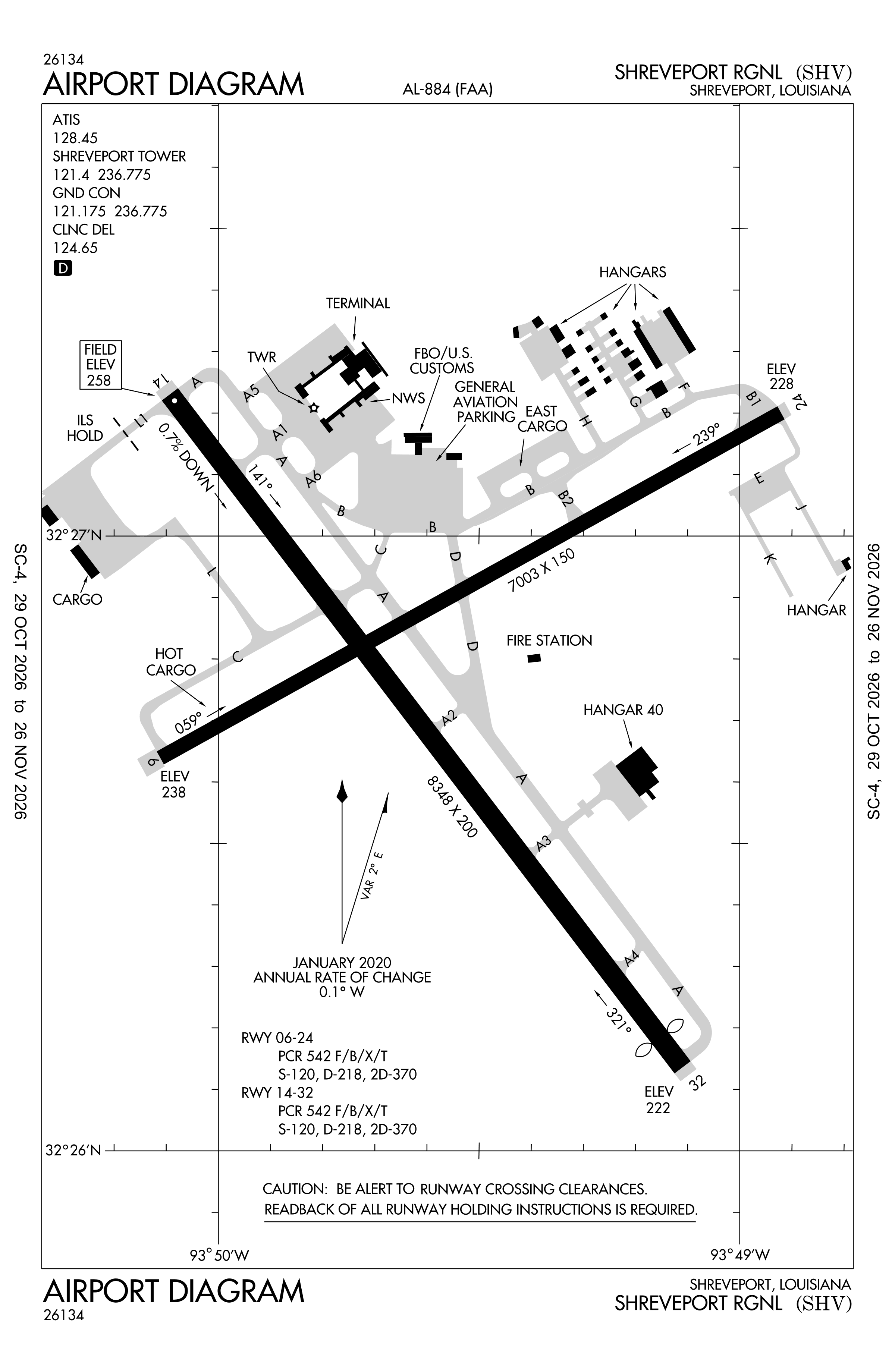
Official FAA PDF (effective Oct 29 to Nov 26)
FAA airport diagram, cycle 2611, effective Oct 29 to Nov 26, 2026. Reference only, not for navigation.
FBOs and services
FBOs
 Signature Shreveport6209 Interstate Drive, Shreveport, LA 71109+1 318-636-1000Hours: 24 hours a day/7 days a weekUNICOM 130.07Signature pageSource: Signature Aviation
- TAC AirBrand website
FBO locations from OpenStreetMap and the operators' own sites, community-maintained or operator-published and may be out of date. Call ahead to confirm services and hours.
Not listed? The FBO may not be in OpenStreetMap. Send a correction.
Data © OpenStreetMap contributors (ODbL), as of Nov 3, 2026; Signature Aviation locations, as of Nov 5, 2026.
Related
- Interactive NOTAM search for KSHV (category filters, maps, share links and a NOTAM decoder)
- Shreveport Regional Airport: codes, map and current weather
- SHV weather and runway winds (METAR and TAF in plain English)
- Flights at SHV now
- NOTAMs for other US airports
More NOTAMs in Louisiana
Times are UTC (Z). Plain-English explanations are generated by cwsi.net from the NOTAM abbreviations and may simplify; the original NOTAM text is authoritative. NOTAMs come from the FAA NOTAM Management Service; cwsi.net refreshes its copy every 3 minutes. cwsi.net is not affiliated with the FAA: always confirm NOTAMs through official sources (a standard briefing or FAA NOTAM Search) before flight.