LCH NOTAMs
Lake Charles Regional Airport, Lake Charles, LA · KLCH
Lake Charles Regional Airport in Lake Charles, Louisiana (IATA LCH, ICAO KLCH) has 19 current NOTAMs (Notices to Air Missions): 12 in effect now and 7 starting later. By category: runways (5), obstacles (4) and communications (3). The list comes from the FAA NOTAM Management Service, refreshed by cwsi.net every few minutes; each NOTAM shows its number, category, start and end time in UTC, and a plain-English reading.
- Runway5
- Obstacle4
- Communications3
- Taxiway2
- Aerodrome1
- Airspace1
- Navaid1
- Procedures1
- Services1
In effect now (12)
OBST TOWER LGT (ASR 1287624) 300053.10N0931234.30W (6.7NM S LCH) 299.9FT (292.0FT AGL) U/S 2611050524-2703050524
TWY J BTN APCH END RWY 15 AND TWY J1 CLSD 2611050100-2611092300
TWY J1 CLSD 2611050100-2611092300
RWY 33 SEQUENCED FLG LGT U/S 2611041413-2611182000EST
RWY 15 RAI LGT U/S 2611010337-2611062000EST
RWY 23 VASI U/S 2610021117-2701292000EST
OBST TOWER LGT (ASR 1022353) 294515.00N0925416.00W (28NM SE LCH) 315FT (312FT AGL) U/S 2609231146-2612222359
OBST TOWER LGT (ASR 1212771) 300954.60N0931524.30W (2.9NM NW LCH) 172.2FT (157.2FT AGL) U/S 2609131445-2701111445
NAV ILS RWY 15 U/S 2609030146-2612182359
OBST TOWER LGT (ASR 1247611) 300837.20N0931509.80W (1.8NM NW LCH) 179.8FT (169.0FT AGL) U/S 2608241400-2612221400
RWY 15 PAPI U/S 2605280629-2705282000EST
IAP LAKE CHARLES RGNL, LAKE CHARLES, LA. RADAR 1, AMDT 5D... PROCEDURE NA. 2503071935-2703071935EST
Starting later (7)
AIRSPACE UAS WI AN AREA DEFINED AS 1NM RADIUS OF 301353.10N0930021.60W (7.2NM E CWF) SFC-200FT AGL 2611051800-2611052100
COM REMOTE TRANS/REC 119.75 U/S 2611060400-2611061150
COM REMOTE TRANS/REC 119.35, 119.8, 120.7, 121.8, 126.25, 257.8, 282.3 U/S 2611060400-2611061150
RWY 05 RWY END ID LGT U/S 2611060400-2611061150
AD AP RVR ALL U/S 2611060400-2611061150
SVC ATIS 118.75 U/S 2611060400-2611061150
COM REMOTE COM OUTLET 121.5, 243.0 NOT AVBL 2611060400-2611061150
Airport diagram
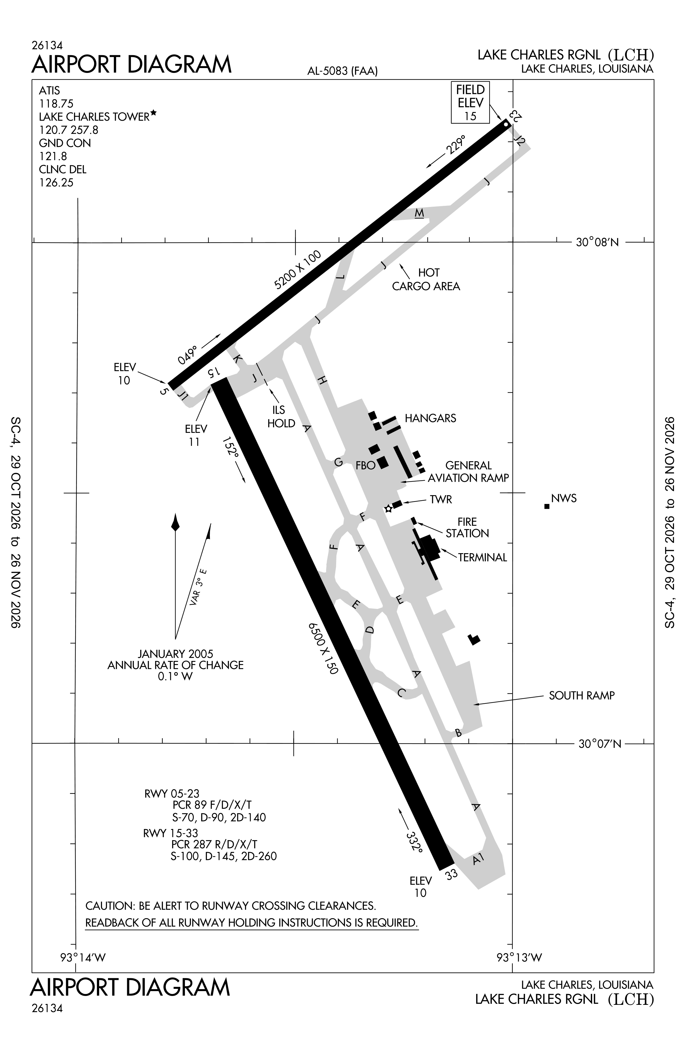
Official FAA PDF (effective Oct 29 to Nov 26)
FAA airport diagram, cycle 2611, effective Oct 29 to Nov 26, 2026. Reference only, not for navigation.
FBOs and services
FBOs
No FBOs are listed in OpenStreetMap for this airport.
Not listed? The FBO may not be in OpenStreetMap. Send a correction.
Data © OpenStreetMap contributors (ODbL), as of Nov 3, 2026.
Related
- Interactive NOTAM search for KLCH (category filters, maps, share links and a NOTAM decoder)
- Lake Charles Regional Airport: codes, map and current weather
- LCH weather and runway winds (METAR and TAF in plain English)
- Flights at LCH now
- NOTAMs for other US airports
More NOTAMs in Louisiana
Times are UTC (Z). Plain-English explanations are generated by cwsi.net from the NOTAM abbreviations and may simplify; the original NOTAM text is authoritative. NOTAMs come from the FAA NOTAM Management Service; cwsi.net refreshes its copy every 3 minutes. cwsi.net is not affiliated with the FAA: always confirm NOTAMs through official sources (a standard briefing or FAA NOTAM Search) before flight.