MLU NOTAMs
Monroe Regional Airport, Monroe, LA · KMLU
Monroe Regional Airport in Monroe, Louisiana (IATA MLU, ICAO KMLU) has 37 current NOTAMs (Notices to Air Missions): 36 in effect now and 1 starting later. By category: obstacles (10), runways (10) and navaids (8). The list comes from the FAA NOTAM Management Service, refreshed by cwsi.net every few minutes; each NOTAM shows its number, category, start and end time in UTC, and a plain-English reading.
- Obstacle10
- Runway10
- Navaid8
- Taxiway3
- Airspace2
- Procedures2
- Communications1
- Services1
In effect now (36)
COM REMOTE COM OUTLET 121.5, 243.0 NOT AVBL 2611032220-2611052359
RWY 14/32 SAFETY AREA OBST BOUNDARY SIGN AT TWY C U/S 2611022116-2611302300
TWY C HLDG PSN SIGN FOR RWY 14/32 U/S 2611022118-2611302300
OBST TOWER LGT (ASR 1057987) 322745.80N0920926.10W (6.8NM WSW MLU) 333.0FT (256.9FT AGL) U/S 2611020805-2701310805
RWY 32 RTHL U/S EXC MEDIUM INTST ON CONS DLY SS-SR 2611012318-2611301251
RWY 14 RTHL U/S EXC MEDIUM INTST ON CONS DLY SS-SR 2611012318-2611301251
RWY 14/32 REDL U/S EXC MEDIUM INTST ON CONS DLY SS-SR 2611012318-2611301251
RWY 04 RTHL U/S EXC MEDIUM INTST ON CONS DLY SS-SR 2611012318-2611301251
RWY 22 RTHL U/S EXC MEDIUM INTST ON CONS DLY SS-SR 2611012318-2611301251
RWY 04/22 REDL U/S EXC MEDIUM INTST ON CONS DLY SS-SR 2611012318-2611301251
TWY ALL EDGE LGT U/S EXC MEDIUM INTST ON CONS DLY SS-SR 2611012343-2611301251
RWY 22 PAPI U/S 2610312031-2611302300
RWY 22 RWY EXIT SIGN AT TWY K RIGHT SIDE MISSING 2610312027-2611302300
TWY D DIRECTIONAL SIGN FOR TWY G MISSING 2610312029-2611302300
RWY 04 PAPI U/S 2610312030-2611302300
SVC PCL ALL U/S 2610312028-2611302300
OBST TOWER LGT (ASR 1289726) 323023.70N0921456.20W (10.8NM W MLU) 367.8FT (256.9FT AGL) U/S 2610310213-2702280213
AIRSPACE FLTCK ACFT OPS WI AN AREA DEFINED AS 5NM RADIUS OF MLU SFC-3500FT AGL ACFT CS FLC72 2611041500-2611052300
OBST TOWER LGT (ASR 1237204) 323051.60N0921334.40W (9.7NM W MLU) 536.1FT (407.2FT AGL) U/S 2610281905-2701262005
OBST TOWER LGT (ASR 1324530) 323200.30N0921031.50W (7.2NM W MLU) 380FT (265FT AGL) U/S 2610270800-2612111400
OBST TOWER LGT (ASR 1321692) 322740.30N0920559.20W (4.4NM SW MLU) 282FT (210FT AGL) U/S 2610270515-2612111115
NAV ILS RWY 04 SABAR LOM U/S 2610201906-2612242359
NAV ILS RWY 04 OM U/S 2610201830-2612242359
OBST TOWER LGT (ASR 1021047) 323018.70N0920954.90W (6.6NM W MLU) 583.0FT (487.9FT AGL) U/S 2610140837-2701120937
OBST TOWER LGT (ASR 1021045) 323106.70N0920530.90W (2.9NM W MLU) 389.1FT (315.0FT AGL) U/S 2610091734-2701071834
NAV ILS RWY 22 OM U/S 2609291321-2709302111EST
NAV ILS RWY 04 U/S 2609211131-2701201800EST
NAV ILS RWY 22 U/S 2609211129-2701201800EST
OBST TOWER LGT (ASR 1059303) 323600.10N0920416.40W (5.6NM NNW MLU) 359.9FT (291.0FT AGL) U/S 2609121138-2612111238
OBST TOWER LGT (ASR 1062577) 322634.40N0920616.20W (5.4NM SW MLU) 303.1FT (229.0FT AGL) U/S 2608300126-2611280226
NAV ILS RWY 04 SABAR LOM U/S 2607220539-PERM
NAV ILS RWY 04 SABAR LOM DECOMMISSIONED 2607220536-PERM
NAV ILS RWY 04 OM U/S 2607220532-PERM
IAP MONROE RGNL, MONROE, LA. ILS OR LOC RWY 4, AMDT 23C... DME REQUIRED EXCEPT FOR ACFT EQUIPPED WITH SUITABLE RNAV SYSTEM WITH GPS, SABAR (ML) LOM OUT OF SERVICE. 2606241437-2806241437EST
OBST TOWER LGT (ASR 1022646) 323325.00N0921049.00W (7.8NM WNW MLU) 437.0FT (315.0FT AGL) U/S 2606221220-2701102359
ODP MONROE RGNL, MONROE, LA. TAKEOFF MINIMUMS AND (OBSTACLE) DEPARTURE PROCEDURES AMDT 6A... IN ADDITION TO EXISTING TAKEOFF OBSTACLE NOTES, ADD: RWY 14: TERRAIN 14 FT FROM DER, 16 FT RIGHT OF CENTERLINE, 74 FT MSL. TERRAIN 15 FT FROM DER, 25 FT LEFT OF CENTERLINE, 74 FT MSL. RWY 32: TREE 4302 FT FROM DER, 19 FT RIGHT OF CENTERLINE, 186 FT MSL. ALL OTHER DATA REMAINS AS PUBLISHED. 2503051918-2703051918EST
Starting later (1)
AIRSPACE FLTCK ACFT OPS WI AN AREA DEFINED AS 5NM RADIUS OF MLU SFC-3500FT AGL ACFT CS FLC72 2611061500-2611061900EST
Airport diagram
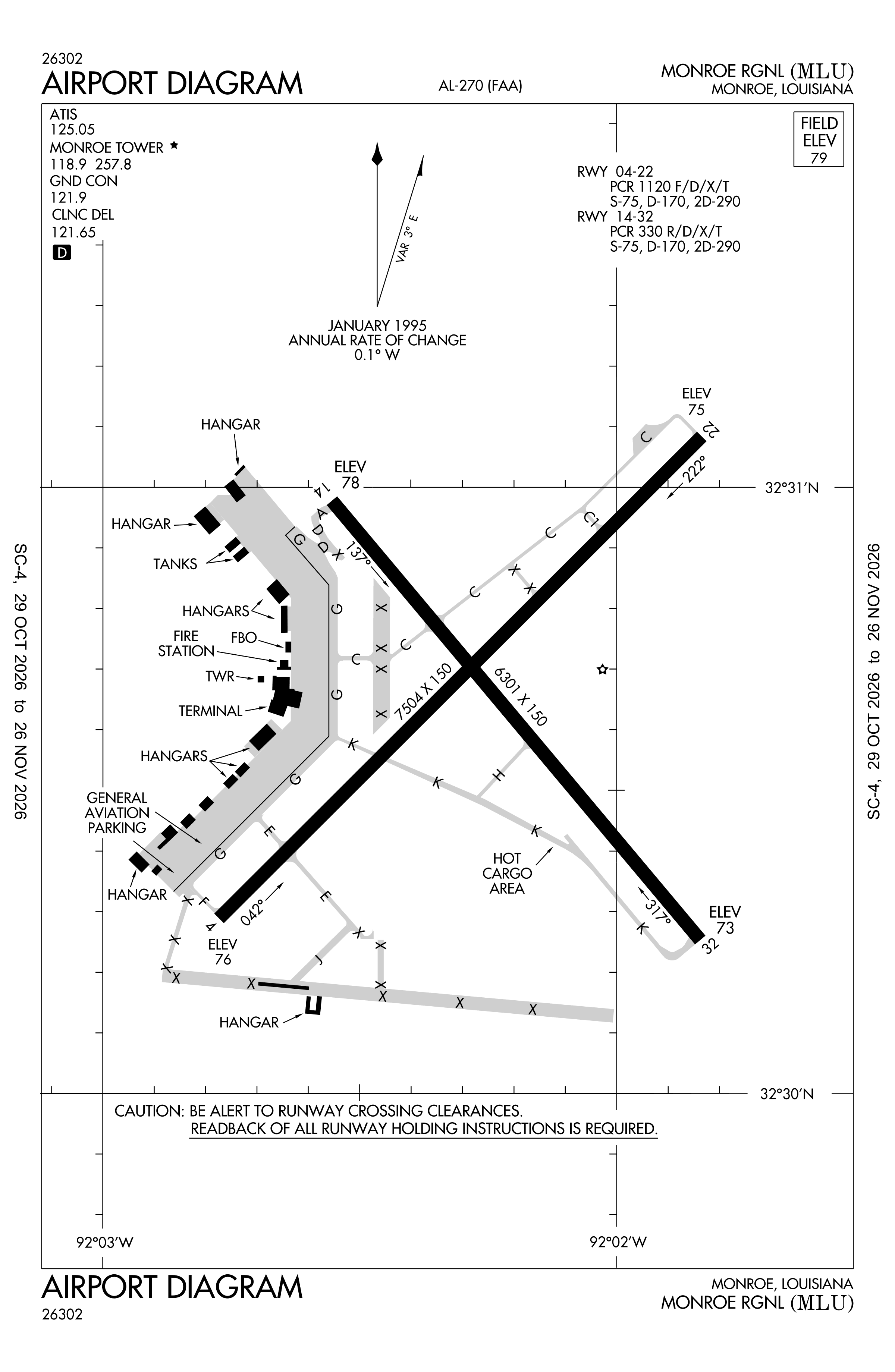
Official FAA PDF (effective Oct 29 to Nov 26)
FAA airport diagram, cycle 2611, effective Oct 29 to Nov 26, 2026. Reference only, not for navigation.
FBOs and services
FBOs
No FBOs are listed in OpenStreetMap for this airport.
Not listed? The FBO may not be in OpenStreetMap. Send a correction.
Data © OpenStreetMap contributors (ODbL), as of Nov 3, 2026.
Related
- Interactive NOTAM search for KMLU (category filters, maps, share links and a NOTAM decoder)
- Monroe Regional Airport: codes, map and current weather
- MLU weather and runway winds (METAR and TAF in plain English)
- Flights at MLU now
- NOTAMs for other US airports
More NOTAMs in Louisiana
Times are UTC (Z). Plain-English explanations are generated by cwsi.net from the NOTAM abbreviations and may simplify; the original NOTAM text is authoritative. NOTAMs come from the FAA NOTAM Management Service; cwsi.net refreshes its copy every 3 minutes. cwsi.net is not affiliated with the FAA: always confirm NOTAMs through official sources (a standard briefing or FAA NOTAM Search) before flight.