AEX NOTAMs
Alexandria International Airport, Alexandria, LA · KAEX
Alexandria International Airport in Alexandria, Louisiana (IATA AEX, ICAO KAEX) has 16 current NOTAMs (Notices to Air Missions): 15 in effect now and 1 starting later. By category: obstacles (6), aprons (3) and runways (3). The list comes from the FAA NOTAM Management Service, refreshed by cwsi.net every few minutes; each NOTAM shows its number, category, start and end time in UTC, and a plain-English reading.
- Obstacle6
- Apron3
- Runway3
- Taxiway2
- Airspace1
- Procedures1
In effect now (15)
OBST TOWER LGT (ASR 1021357) 311952.00N0924258.00W (8.7NM W AEX) 568.9FT (413.1FT AGL) U/S 2611050638-2611200538
TWY B CLSD 2611051300-2611052000
OBST TOWER LGT (ASR 1212196) 311515.80N0923246.30W (4.4NM S AEX) 342.2FT (270.0FT AGL) U/S 2610291047-2611130947
TWY B2 HLDG PSN MARKINGS NOT STD 2610281638-2611102300
APRON SOUTH APN ENTRANCE ADJ ARFF CLSD 2610271251-2611102300
APRON SOUTH APN WIP CONST ADJ LGTD AND BARRICADED 2610271237-2611102300
RWY 18 PAPI U/S 2610271231-2611102300
RWY 36 PAPI U/S 2610271229-2611102300
OBST TOWER LGT (ASR 1228306) 312200.50N0923709.50W (4.3NM WNW AEX) 389.1FT (304.1FT AGL) U/S 2610271110-2701250400
OBST TOWER LGT (ASR 1021357) 311952.00N0924258.00W (8.6NM W AEX) 568.9FT (413.1FT AGL) U/S 2610220811-2611060711
OBST TOWER LGT (ASR 1325940) 311946.90N0924238.40W (8.3NM W AEX) 466FT (292FT AGL) U/S 2610110439-2611250439
OBST TOWER LGT (ASR 1226986) 312645.10N0924643.00W (13.7NM WNW AEX) 491.8FT (361.9FT AGL) U/S 2609091714-2612081814
IAP ALEXANDRIA INTL, ALEXANDRIA, LA. ILS OR LOC RWY 14, AMDT 1D... RNAV (GPS) RWY 14, AMDT 1D... RNAV (GPS) RWY 32, AMDT 1D... RNAV (GPS) RWY 36, ORIG-D... VOR RWY 14, ORIG-F... CIRCLING CAT A MDA 560/HAA 472. 2607091921-2806171738EST
RWY 18/36 CHANGED TO 8503FT X 150FT. DECLARED DIST: RWY 18 TORA 8503FT TODA 8503FT ASDA 8503FT LDA 8503FT. RWY 36 TORA 8503FT TODA 8503FT ASDA 8503FT LDA 8503FT. 2607071627-PERM
APRON SOUTH RAMP AIR CARRIER OPS CLSD TO PUSHBACK EXC PPR 318-443-5566 2603261510-2612312359
Starting later (1)
AIRSPACE FLTCK ACFT OPS WI AN AREA DEFINED AS 5NM RADIUS OF AEX SFC-3500FT AGL ACFT CS FLC72 2611051400-2611052200EST
Airport diagram
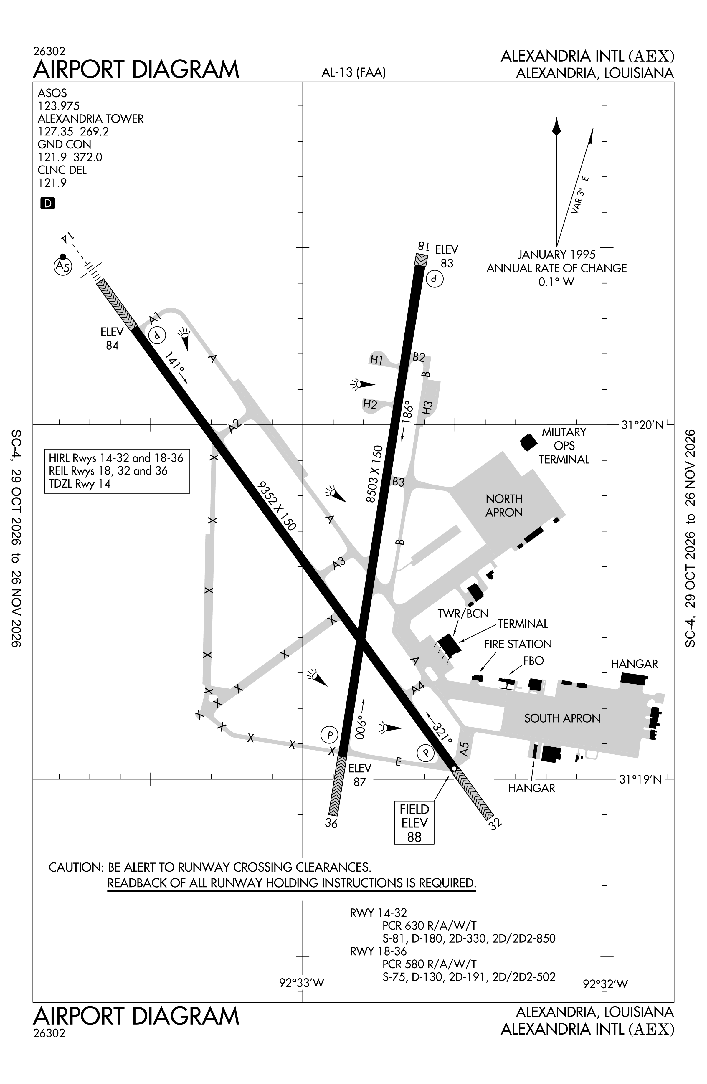
Official FAA PDF (effective Oct 29 to Nov 26)
FAA airport diagram, cycle 2611, effective Oct 29 to Nov 26, 2026. Reference only, not for navigation.
FBOs and services
FBOs
- Million Air Alexandria1303 Billy Mitchell Boulevard, Alexandria, LA 71303+1 318-443-5566Hours: 24/7Million Air pageSource: Million Air
FBO locations from the operators' own sites, may be out of date. Call ahead to confirm services and hours.
Not listed? The FBO may not be in OpenStreetMap. Send a correction.
Million Air locations, as of Nov 5, 2026.
Related
- Interactive NOTAM search for KAEX (category filters, maps, share links and a NOTAM decoder)
- Alexandria International Airport: codes, map and current weather
- AEX weather and runway winds (METAR and TAF in plain English)
- Flights at AEX now
- NOTAMs for other US airports
More NOTAMs in Louisiana
Times are UTC (Z). Plain-English explanations are generated by cwsi.net from the NOTAM abbreviations and may simplify; the original NOTAM text is authoritative. NOTAMs come from the FAA NOTAM Management Service; cwsi.net refreshes its copy every 3 minutes. cwsi.net is not affiliated with the FAA: always confirm NOTAMs through official sources (a standard briefing or FAA NOTAM Search) before flight.