RFD NOTAMs
Chicago Rockford International Airport, Rockford, IL · KRFD
Chicago Rockford International Airport in Rockford, Illinois (IATA RFD, ICAO KRFD) has 30 current NOTAMs (Notices to Air Missions): 28 in effect now and 2 starting later. By category: taxiways (12), runways (7) and obstacles (4). The list comes from the FAA NOTAM Management Service, refreshed by cwsi.net every few minutes; each NOTAM shows its number, category, start and end time in UTC, and a plain-English reading.
- Taxiway12
- Runway7
- Obstacle4
- Procedures4
- Aerodrome1
- Communications1
- Navaid1
In effect now (28)
RWY 25 FICON 5/5/5 100 PCT WET OBS AT 2611051239. 2611051239-2611061239
RWY 19 FICON 5/5/5 70 PCT WET OBS AT 2611051239. 2611051239-2611061239
TWY F BTN TWY A AND TWY B CLSD LGTD AND BARRICADED 2611042210-2611252359
TWY F BTN TWY A AND TWY B WIP LGTD AND BARRICADED 2611042202-2611252359
TWY F BTN TWY A AND TWY B CLSD 2611042040-2611252359
RWY 25 FICON 5/5/5 100 PCT WET OBS AT 2611041911. 2611041911-2611051911
RWY 19 FICON 5/5/5 100 PCT WET OBS AT 2611041910. 2611041910-2611051910
TWY B ELEVATED RWY GUARD LGT AT APCH END RWY 19 NOT STD 2611040003-2612312359
TWY H HLDG PSN SIGN LGT U/S 2610301957-2611272359
TWY A HLDG PSN SIGN BTN TWY D AND RWY 07/25 LGT U/S 2610301955-2611272359
RWY 07/25 SAFETY AREA NOT STD 2610301514-2710292359
RWY 01/19 SAFETY AREA NOT STD 2610301512-2710292359
TWY M ELEVATED RWY GUARD LGT BTN TWY P AND RWY 07/25 U/S 2610300037-2611302359
TWY A ELEVATED RWY GUARD LGT BTN TWY D AND RWY 07/25 NOT STD 2610300033-2611302359
TWY A BTN RWY 07/25 AND TWY F CLSD 2610281904-2611062359
TWY F BTN TWY B AND TERMINAL RAMP CLSD 2610281902-2611062359
TWY G IN PAVEMENT RWY GUARD LGT BTN RWY 07/25 AND TWY F NOT STD 2610280957-2705312300
OBST TOWER LGT (ASN 2016-AGL-8993-OE) 421139N0890412W (1.2NM E RFD) 845FT (89FT AGL) U/S 2610270330-2612110325
IAP CHICAGO/ROCKFORD INTL, CHICAGO/ROCKFORD, IL. RNAV (GPS) RWY 25, AMDT 1C... LNAV CAT C/D VISIBILITY 1 1/4 SM. 2610201407-2810201407EST
OBST TOWER LGT (ASR 1208846) 421125.00N0891139.70W (4.3NM W RFD) 1048.9FT (258.9FT AGL) U/S 2610160012-2701140112
OBST POWER LINE LGT(ASN 2016-AGL-8989-OE) 421157N0890418W (1NM E RFD) 829FT (89FT AGL) U/S 2609290013-2611130200
OBST POWER LINE LGT(ASN 2016-AGL-8989-OE) 421157N0890418W (1NM E RFD) 829FT (89FT AGL) U/S 2609290013-2611130011
NAV ILS RWY 07 IM U/S 2609180841-2701272000EST
TWY P1 SAFETY AREA IRREGULAR SFC WEST SIDE 2602132109-2608282359 2608271632-2612312359
AD AP BIRD ACT 2512311823-2612312359
IAP CHICAGO/ROCKFORD INTL, CHICAGO/ROCKFORD, IL. RADAR-1, AMDT 11... S-25 MDA 1260/HAT 524 ALL CATS, VIS CAT C/D 1 1/2. 2503251451-2703251451EST
IAP CHICAGO/ROCKFORD INTL, CHICAGO/ROCKFORD, IL. RNAV (GPS) RWY 7, AMDT 1E... LNAV/VNAV DA 1172/ HAT 431 ALL CATS. 2503191447-2703191447EST
IAP CHICAGO/ROCKFORD INTL, CHICAGO/ROCKFORD, IL. RNAV (GPS) RWY 25, AMDT 1C... LNAV/VNAV DA 1259/HAT 523 ALL CATS, VIS 1 1/2 ALL CATS. 2502121424-2702151424EST
Starting later (2)
COM CLR DELIVERY 121.65 U/S 2611120500-2611121100
RWY 07 ALS U/S 2611051400-2611051700
Airport diagram
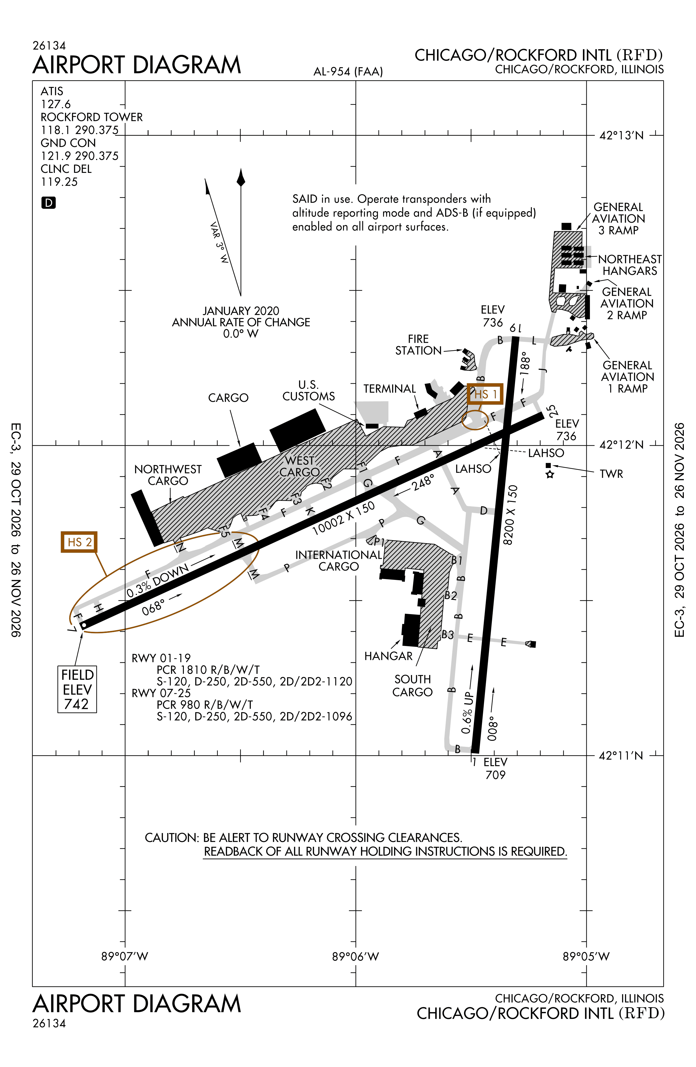
Official FAA PDF (effective Oct 29 to Nov 26)
FAA airport diagram, cycle 2611, effective Oct 29 to Nov 26, 2026. Reference only, not for navigation.
FBOs and services
FBOs
- Emery Air+1 815-968-8287Fuel (OpenStreetMap): Jet A, 100LL
FBO locations from OpenStreetMap, community-maintained and may be out of date. Call ahead to confirm services and hours.
Not listed? The FBO may not be in OpenStreetMap. Send a correction.
Data © OpenStreetMap contributors (ODbL), as of Nov 3, 2026.
Related
- Interactive NOTAM search for KRFD (category filters, maps, share links and a NOTAM decoder)
- Chicago Rockford International Airport: codes, map and current weather
- RFD weather and runway winds (METAR and TAF in plain English)
- Flights at RFD now
- NOTAMs for other US airports
More NOTAMs in Illinois
Times are UTC (Z). Plain-English explanations are generated by cwsi.net from the NOTAM abbreviations and may simplify; the original NOTAM text is authoritative. NOTAMs come from the FAA NOTAM Management Service; cwsi.net refreshes its copy every 3 minutes. cwsi.net is not affiliated with the FAA: always confirm NOTAMs through official sources (a standard briefing or FAA NOTAM Search) before flight.