CMI NOTAMs
University of Illinois Willard Airport, Savoy, IL · KCMI
University of Illinois Willard Airport in Savoy, Illinois (IATA CMI, ICAO KCMI) has 16 current NOTAMs (Notices to Air Missions): 14 in effect now and 2 starting later. By category: runways (6), airspace (2) and aprons (2). The list comes from the FAA NOTAM Management Service, refreshed by cwsi.net every few minutes; each NOTAM shows its number, category, start and end time in UTC, and a plain-English reading.
- Runway6
- Airspace2
- Apron2
- Procedures2
- Taxiway2
- Navaid1
- Obstacle1
In effect now (14)
RWY 14R FICON 5/5/5 100 PCT WET OBS AT 2611041420. 2611041420-2611051420
APRON ALL FICON WET OBS AT 2611041420. 2611041420-2611051420
RWY 22 FICON 5/5/5 100 PCT WET OBS AT 2611041419. 2611041419-2611051419
RWY 14L FICON 5/5/5 100 PCT WET OBS AT 2611041418. 2611041418-2611051418
TWY ALL FICON WET OBS AT 2611041418. 2611041418-2611051418
APRON FIXED BASE OPR RAMP SE 380FT CLSD 2610261806-2611132200
TWY A5 CLSD 2610261805-2611132300
OBST TOWER LGT (ASR 1207783) 395800.00N0883520.00W (15.0NM WSW CMI) 1017.1FT (294.9FT AGL) U/S 2610191127-2701171227
RWY 22 CMI RWY 22 VASI DECOMMISSIONED 2607220522-PERM
RWY 22 PAPI COMMISSIONED 2607060021-PERM
RWY 04 PAPI COMMISSIONED 2607060019-PERM
IAP UNIVERSITY OF ILLINOIS/WILLARD, CHAMPAIGN/URBANA, IL. RNAV (GPS) RWY 4, ORIG-B... ADD PROFILE NOTE: VGSI AND RNAV GLIDEPATH NOT COINCIDENT. 2607021721-2807021721EST
IAP UNIVERSITY OF ILLINOIS/WILLARD, CHAMPAIGN/URBANA, IL. RNAV (GPS) RWY 22, AMDT 1C... ADD PROFILE NOTE: VGSI AND RNAV GLIDEPATH NOT COINCIDENT. 2607021721-2807021721EST
NAV ILS RWY 32R OM U/S 2604241444-2706152111EST
Starting later (2)
AIRSPACE UAS WI AN AREA DEFINED AS 0.5NM RADIUS OF 400105.90N0881314.20W (2.8NM ESE CMI) SFC-50FT AGL 2611061400-2611062200
AIRSPACE UAS WI AN AREA DEFINED AS 0.5NM RADIUS OF 400105.90N0881314.20W (2.8NM ESE CMI) SFC-50FT AGL 2611051400-2611052200
Airport diagram
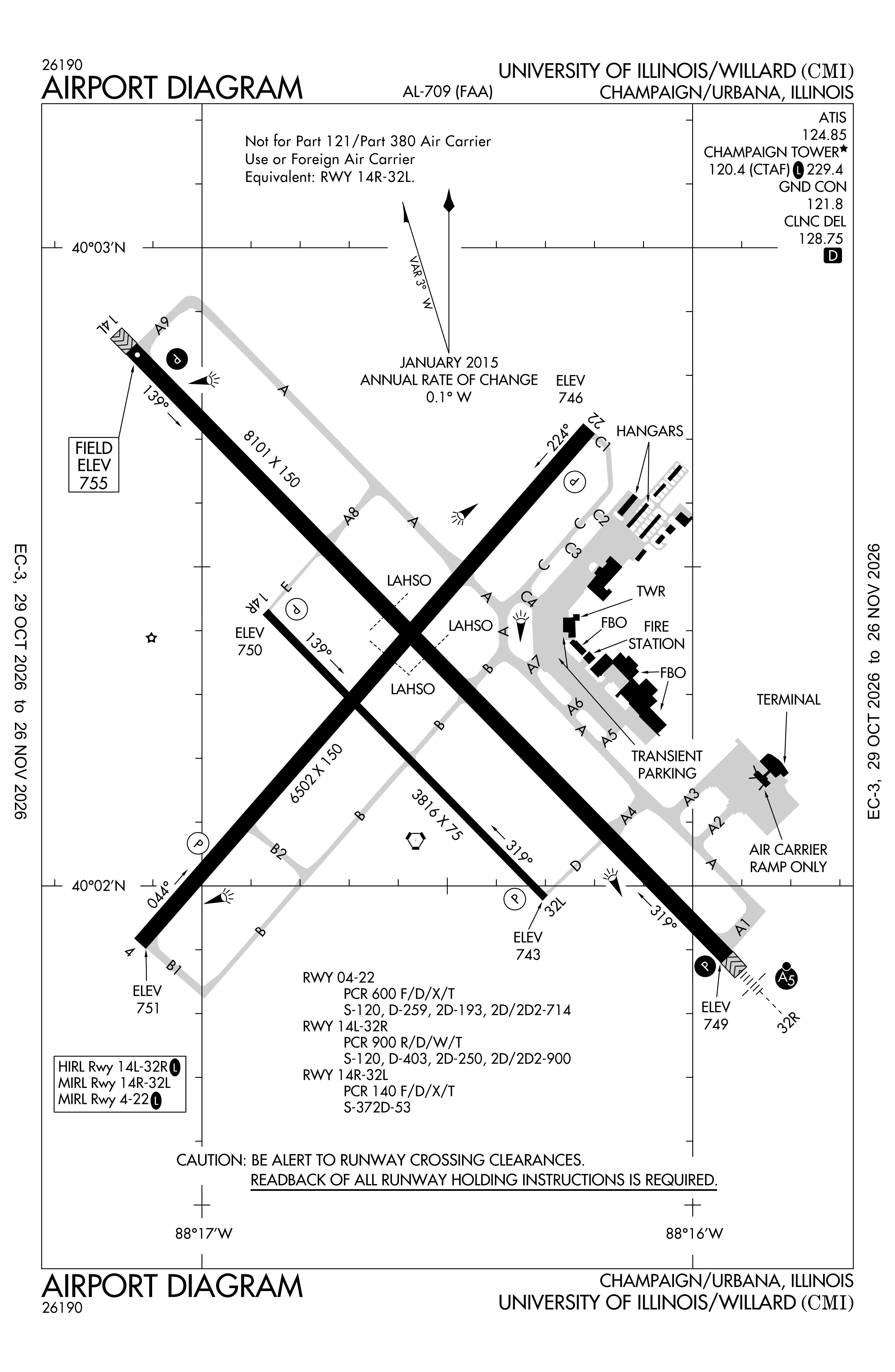
Official FAA PDF (effective Oct 29 to Nov 26)
FAA airport diagram, cycle 2611, effective Oct 29 to Nov 26, 2026. Reference only, not for navigation.
FBOs and services
FBOs
No FBOs are listed in OpenStreetMap for this airport.
Not listed? The FBO may not be in OpenStreetMap. Send a correction.
Data © OpenStreetMap contributors (ODbL), as of Nov 3, 2026.
Related
- Interactive NOTAM search for KCMI (category filters, maps, share links and a NOTAM decoder)
- University of Illinois Willard Airport: codes, map and current weather
- CMI weather and runway winds (METAR and TAF in plain English)
- Flights at CMI now
- NOTAMs for other US airports
More NOTAMs in Illinois
Times are UTC (Z). Plain-English explanations are generated by cwsi.net from the NOTAM abbreviations and may simplify; the original NOTAM text is authoritative. NOTAMs come from the FAA NOTAM Management Service; cwsi.net refreshes its copy every 3 minutes. cwsi.net is not affiliated with the FAA: always confirm NOTAMs through official sources (a standard briefing or FAA NOTAM Search) before flight.