MLI NOTAMs
Quad Cities International Airport, Moline, IL · KMLI
Quad Cities International Airport in Moline, Illinois (IATA MLI, ICAO KMLI) has 9 current NOTAMs (Notices to Air Missions): 8 in effect now and 1 starting later. By category: obstacles (5), procedures (2) and runways (1). The list comes from the FAA NOTAM Management Service, refreshed by cwsi.net every few minutes; each NOTAM shows its number, category, start and end time in UTC, and a plain-English reading.
- Obstacle5
- Procedures2
- Runway1
- Services1
In effect now (8)
RWY 27 HLDG PSN SIGN AT RWY13/31 LEFT SIDE LGT U/S 2611042352-2611060200
OBST TOWER LGT (ASN 2024-AGL-5819-OE) 412733N0903907W (6.5NM W MLI) 775FT (215FT AGL) U/S 2610280503-2612120457
OBST TOWER LGT (ASN 2024-ACE-2393-OE) 412808N0903927W (6.9NM W MLI) 765FT (215FT AGL) U/S 2610280503-2612120459
OBST TOWER LGT (ASN 2024-ACE-2394-OE) 412751N0903918W (6.7NM W MLI) 775FT (215FT AGL) U/S 2610270338-2612110335
OBST TOWER LGT (ASR 1008680) 411423.10N0902542.40W (13NM S MLI) 1004FT (295FT AGL) U/S 2610261524-2612102124
OBST TOWER LGT (ASR 1200487) 411559.10N0904538.50W (15.8NM SW MLI) 992FT (241FT AGL) U/S 2610161145-2611301140
IAP QUAD CITIES INTL, MOLINE, IL. RNAV (GPS) RWY 31, AMDT 1D... LNAV MDA 1160/HAT 577 ALL CATS, VIS CAT C/D 1 5/8. CIRCLING CAT A MDA 1160/HAA 570. 2610151433-2810151433EST
IAP QUAD CITIES INTL, MOLINE, IL. ILS OR LOC RWY 27, AMDT 2C... S-LOC 27 CAT C RVR 4500. 2502181546-2702181544EST
Starting later (1)
SVC SSR U/S 2611051400-2611051900
Airport diagram
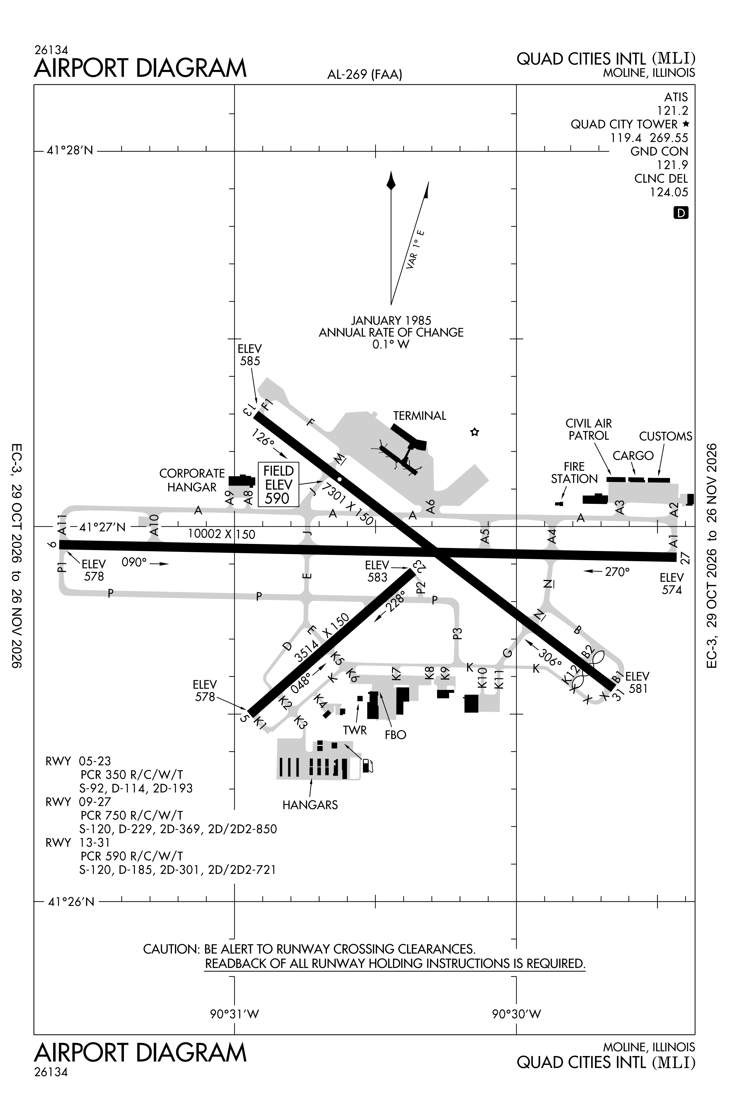
Official FAA PDF (effective Oct 29 to Nov 26)
FAA airport diagram, cycle 2611, effective Oct 29 to Nov 26, 2026. Reference only, not for navigation.
FBOs and services
FBOs
No FBOs are listed in OpenStreetMap for this airport.
Not listed? The FBO may not be in OpenStreetMap. Send a correction.
Data © OpenStreetMap contributors (ODbL), as of Nov 3, 2026.
Related
- Interactive NOTAM search for KMLI (category filters, maps, share links and a NOTAM decoder)
- Quad Cities International Airport: codes, map and current weather
- MLI weather and runway winds (METAR and TAF in plain English)
- Flights at MLI now
- NOTAMs for other US airports
More NOTAMs in Illinois
Times are UTC (Z). Plain-English explanations are generated by cwsi.net from the NOTAM abbreviations and may simplify; the original NOTAM text is authoritative. NOTAMs come from the FAA NOTAM Management Service; cwsi.net refreshes its copy every 3 minutes. cwsi.net is not affiliated with the FAA: always confirm NOTAMs through official sources (a standard briefing or FAA NOTAM Search) before flight.