BMI NOTAMs
Central Illinois Regional Airport, Bloomington, IL · KBMI
Central Illinois Regional Airport in Bloomington, Illinois (IATA BMI, ICAO KBMI) has 36 current NOTAMs (Notices to Air Missions): 28 in effect now and 8 starting later. By category: taxiways (10), navaids (8) and obstacles (5). The list comes from the FAA NOTAM Management Service, refreshed by cwsi.net every few minutes; each NOTAM shows its number, category, start and end time in UTC, and a plain-English reading.
- Taxiway10
- Navaid8
- Obstacle5
- Procedures5
- Runway5
- Apron2
- Airspace1
In effect now (28)
TWY ALL FICON WET OBS AT 2611050031. COND NOT MNT 2611050700-2611050900. 2611050031-2611060031
APRON ALL FICON WET OBS AT 2611050030. COND NOT MNT 2611050700-2611050900. 2611050030-2611060030
IAP CENTRAL IL RGNL/BLOOMINGTON-NORMAL, BLOOMINGTON/NORMAL, IL. LOC BC RWY 11, AMDT 13... RADAR REQUIRED FOR PROCEDURE ENTRY EXCEPT FOR ACFT EQUIPPED WITH SUITABLE RNAV SYSTEM WITH GPS, PIA VORTAC OUT OF SERVICE. 2611041440-2702262111EST
IAP CENTRAL IL RGNL/BLOOMINGTON-NORMAL, BLOOMINGTON/NORMAL, IL. LOC BC RWY 11, AMDT 13... RADAR REQUIRED FOR PROCEDURE ENTRY EXCEPT FOR ACFT EQUIPPED WITH SUITABLE RNAV SYSTEM WITH GPS, PIA VORTAC OUT OF SERVICE. 2611041440-2702262111EST
IAP CENTRAL IL RGNL/BLOOMINGTON-NORMAL, BLOOMINGTON/NORMAL, IL. ILS OR LOC RWY 2, AMDT 1... DME REQUIRED EXCEPT FOR ACFT EQUIPPED WITH SUITABLE RNAV SYSTEM WITH GPS, PIA VORTAC OUT OF SERVICE. 2611041440-2702262111EST
APRON WEST RAMP EDGE LGT U/S 2611041021-2611131200
TWY D LGT BTN WEST RAMP AND TWY E U/S 2611031033-2611092200
TWY C LGT U/S 2611031032-2611092200
TWY A LGT BTN TWY E AND WEST RAMP U/S 2611031031-2611092200
RWY 02/20 CLSD 2611051230-2611051530
NAV ILS RWY 02 U/S 2611051230-2611052300
NAV ILS RWY 20 U/S 2611051230-2611052300
NAV ILS RWY 20 IM/OM U/S 2610310829-2705202000EST
NAV ILS RWY 20 EGROW LOM U/S 2610310824-2703312000EST
TWY G EDGE LGT BTN RWY 11/29 AND TWY E NOT STD 2610292120-2611202130
TWY G CL MARKINGS BTN RWY 11/29 AND TWY G1 NOT STD 2610261819-2611192359
TWY G EDGE MARKINGS BTN RWY 11/29 AND TWY G1 NOT STD 2610261818-2611192359
TWY G HLDG PSN MARKINGS FOR RWY 11/29 SOUTH SIDE NOT STD 2610261812-2611192359
NAV ILS RWY 29 OM U/S 2610241653-2712032000EST
OBST WIND TURBINE LGT (ASN 2024-WTE-3203-OE) 403730N0883508W (17.5NM ENE BMI) 1143FT (380FT AGL) U/S 2610240716-2612080603
OBST TOWER LGT (ASR 1008831) 403215.00N0890115.00W (6.0NM NW BMI) 1122.0FT (291.0FT AGL) U/S 2609301453-2612291553
OBST WIND TURBINE LGT (ASN 2020-WTE-3440-OE) 404005N0884147W (15.3NM NE BMI) 1091FT (328FT AGL) U/S 2609041117-2611230601
IAP CENTRAL IL RGNL/BLOOMINGTON-NORMAL, BLOOMINGTON/NORMAL, IL. ILS OR LOC RWY 20, AMDT 4A... S-LOC 20: DME REQUIRED EXCEPT FOR ACFT EQUIPPED WITH SUITABLE RNAV SYSTEM WITH GPS, LHJ LOM OUT OF SERVICE. 2608121907-2703241907EST
IAP CENTRAL IL RGNL/BLOOMINGTON-NORMAL, BLOOMINGTON/NORMAL, IL. ILS RWY 20 (CAT II), AMDT 4A ... S-ILS 20 CAT II NA EXCEPT FOR AIRCRAFT EQUIPPED WITH RADIO ALTIMETER. I-LHJ INNER MARKER OUT OF SERVICE 2607101551-2702191551EST
NAV ILS RWY 29 U/S 2606111200-2611302200
RWY 11/29 CLSD EXC XNG 2606111200-2611302330
OBST TOWER LGT (ASR 1010146) 403845.00N0891045.00W (15.7NM NW BMI) 1747.0FT (1006.9FT AGL) U/S 2605061841-2611062359
OBST TOWER (ASN UNKNOWN) 402434N0884602W (8.2NM ESE BMI) 1245FT (319FT AGL) NOT LGTD 1903051230-PERM
Starting later (8)
NAV ILS RWY 02 U/S 2611061230-2611062300
NAV ILS RWY 20 U/S 2611061230-2611062300
AIRSPACE UAS WI AN AREA DEFINED AS 1NM RADIUS OF 402736N0885924W (3.4NM SW BMI) SFC-400FT AGL 2611061400-2611062359
TWY D BTN RWY 11/29 AND TWY E CLSD 2611051600-2611052130
TWY B2 CLSD 2611051600-2611052130
RWY 02/20 CLSD TO TGL 2611061230-2611061700
RWY 02/20 CLSD 2611071230-2611071600
RWY 02/20 CLSD EXC SKED ACFT AND EMERG ACFT OR 30MIN PPR 309-834-7396 2611061230-2611061700
Airport diagram
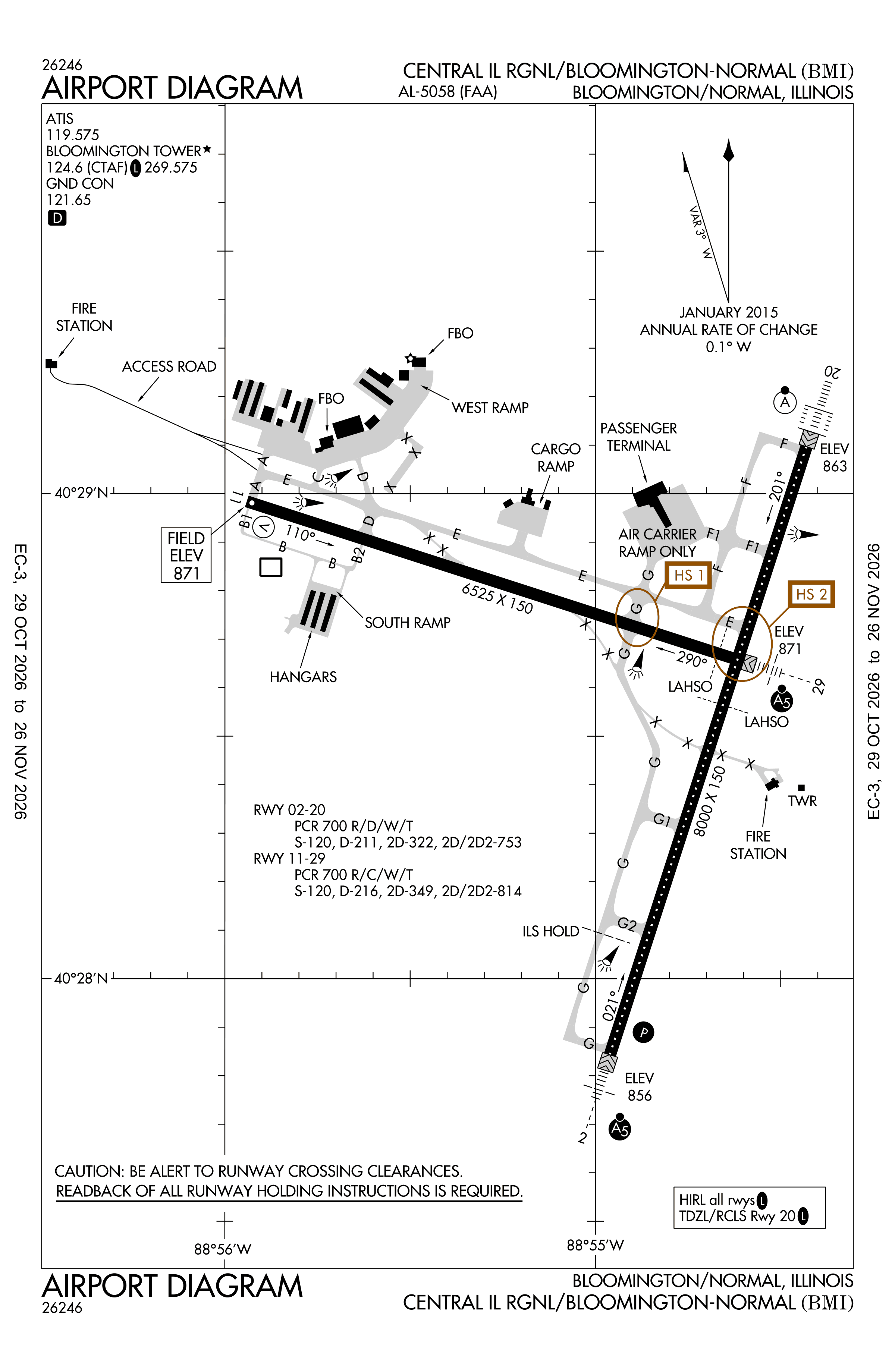
Official FAA PDF (effective Oct 29 to Nov 26)
FAA airport diagram, cycle 2611, effective Oct 29 to Nov 26, 2026. Reference only, not for navigation.
FBOs and services
FBOs
No FBOs are listed in OpenStreetMap for this airport.
Not listed? The FBO may not be in OpenStreetMap. Send a correction.
Data © OpenStreetMap contributors (ODbL), as of Nov 3, 2026.
Related
- Interactive NOTAM search for KBMI (category filters, maps, share links and a NOTAM decoder)
- Central Illinois Regional Airport: codes, map and current weather
- BMI weather and runway winds (METAR and TAF in plain English)
- Flights at BMI now
- NOTAMs for other US airports
More NOTAMs in Illinois
Times are UTC (Z). Plain-English explanations are generated by cwsi.net from the NOTAM abbreviations and may simplify; the original NOTAM text is authoritative. NOTAMs come from the FAA NOTAM Management Service; cwsi.net refreshes its copy every 3 minutes. cwsi.net is not affiliated with the FAA: always confirm NOTAMs through official sources (a standard briefing or FAA NOTAM Search) before flight.