MOB NOTAMs
Mobile Regional Airport, Mobile, AL · KMOB
Mobile Regional Airport in Mobile, Alabama (IATA MOB, ICAO KMOB) has 27 current NOTAMs (Notices to Air Missions): 23 in effect now and 4 starting later. By category: obstacles (13), procedures (5) and services (3). The list comes from the FAA NOTAM Management Service, refreshed by cwsi.net every few minutes; each NOTAM shows its number, category, start and end time in UTC, and a plain-English reading.
- Obstacle13
- Procedures5
- Services3
- Communications2
- Runway2
- Apron1
- Taxiway1
In effect now (23)
OBST TOWER LGT (ASR 1254452) 304231.30N0881822.40W (3.4NM WNW MOB) 428.1FT (227.0FT AGL) U/S 2610300602-2611140502
OBST TOWER LGT (ASR 1245379) 303704.40N0881053.90W (5.4NM SE MOB) 245.7FT (169.9FT AGL) U/S 2610291048-2611130948
OBST TOWER LGT (ASR 1289877) 304953.30N0881429.20W (8.4NM N MOB) 568FT (304FT AGL) U/S 2610270027-2612110627
OBST TOWER LGT (ASR 1209419) 303623.00N0881439.50W (5.1NM S MOB) 488.2FT (304.1FT AGL) U/S 2610250704-2701230804
OBST TOWER LGT (ASR 1245985) 303834.60N0881133.90W (3.9NM SE MOB) 323.2FT (162.1FT AGL) U/S 2610241616-2701220400
OBST TOWER LGT (ASR 1231139) 304654.50N0881621.90W (5.6NM NNW MOB) 509.5FT (264.8FT AGL) U/S 2610230640-2611070540
COM REMOTE COM OUTLET 122.2 U/S 2610201502-2611122000EST
OBST TOWER LGT (ASR 1224205) 303623.70N0881554.30W (5.2NM S MOB) 486FT (340FT AGL) U/S 2610161637-2611301637
OBST TOWER LGT (ASR 1251863) 305222.10N0881631.00W (10.9NM N MOB) 547.2FT (311.0FT AGL) U/S 2610152258-2702122258
RWY 15 RVRR U/S 2610151210-2611062000EST
RWY 33 RVRT U/S 2610151209-2611062000EST
OBST TOWER LGT (ASR 1034126) 304959.10N0881430.60W (8.5NM NE MOB) 660.1FT (396.0FT AGL) U/S 2610150950-2701131050
TWY C BTN TWY A AND TWY C3 CLSD TO ACFT WINGSPAN MORE THAN 78FT 2610131246-2612312359
OBST TOWER LGT (ASR 1222028) 305333.10N0883705.30W (22.7NM WNW MOB) 601.7FT (348.8FT AGL) U/S 2610092214-2702062214
IAP MOBILE RGNL, MOBILE, AL. ILS OR LOC RWY 15, AMDT 32A... ILS RWY 15 (SA CAT I AND II), AMDT 32A.... MISSED APPROACH: CLIMB TO 2000 ON HEADING 147 AND RIGHT TURN ON BFM VORTAC R-242 TO SAINT/BFM 9.20 DME AND HOLD (DME REQUIRED). RADAR REQUIRED FOR PROCEDURE ENTRY EXCEPT FOR ACFT EQUIPPED WITH SUITABLE RNAV SYSTEM WITH GPS, SJI VOR OUT OF SERVICE. 2610021627-2612091627EST
IAP MOBILE RGNL, MOBILE, AL. ILS OR LOC RWY 33, AMDT 7C... MISSED APPROACH: CLIMB TO 700 THEN CLIMBING RIGHT TURN TO 2000 DIRECT BFM VORTAC AND HOLD., SJI VOR OUT OF SERVICE. 2610021627-2612091627EST
OBST TOWER LGT (ASR 1216599) 305004.90N0881040.80W (9.3NM NNE MOB) 448.8FT (294.9FT AGL) U/S 2609210157-2612200257
OBST TOWER LGT (ASR 1260161) 310332.00N0883031.00W (25NM NNW MOB) 618FT (308FT AGL) U/S 2609080109-2612062359
OBST TOWER LGT (ASR 1061047) 304803.40N0881733.00W (7.0NM NNW MOB) 484.9FT (304.8FT AGL) U/S 2608221455-2611210400
IAP MOBILE RGNL, MOBILE, AL. ILS OR LOC RWY 15, AMDT 32A... ILS OR LOC RWY 33, AMDT 7C... VOR OR TACAN-A, AMDT 2B... ILS RWY 15 (SA CAT I AND II), AMDT 32A... ALTERNATE MINIMUMS NA EXCEPT FOR ACFT EQUIPPED WITH SUITABLE RNAV SYSTEM WITH GPS, BFM VORTAC UNMONITORED. 2608051628-2611181628EST
APRON EAST APN NONMOVEMENT AREA BDRY MARKINGS FADED 2604221327-2612310559
IAP MOBILE RGNL, MOBILE, AL. RADAR-1, AMDT 5B... ASR-33 MDA 600/HAT 381 ALL CATS. 2602091955-2809211955EST
IAP MOBILE RGNL, MOBILE, AL. VOR OR TACAN-A, AMDT 2B... VOR PORTION NA EXCEPT FOR ACFT EQUIPPED WITH SUITABLE RNAV SYSTEM WITH GPS. 2505121908-2705131908EST
Starting later (4)
SVC TAR/SSR U/S 2611121400-2611122200
COM REMOTE COM OUTLET 122.2 U/S 2611120500-2611120800
SVC ATIS U/S 2611100900-2611101300
SVC ATIS 124.75 U/S 2611100900-2611101300
Airport diagram
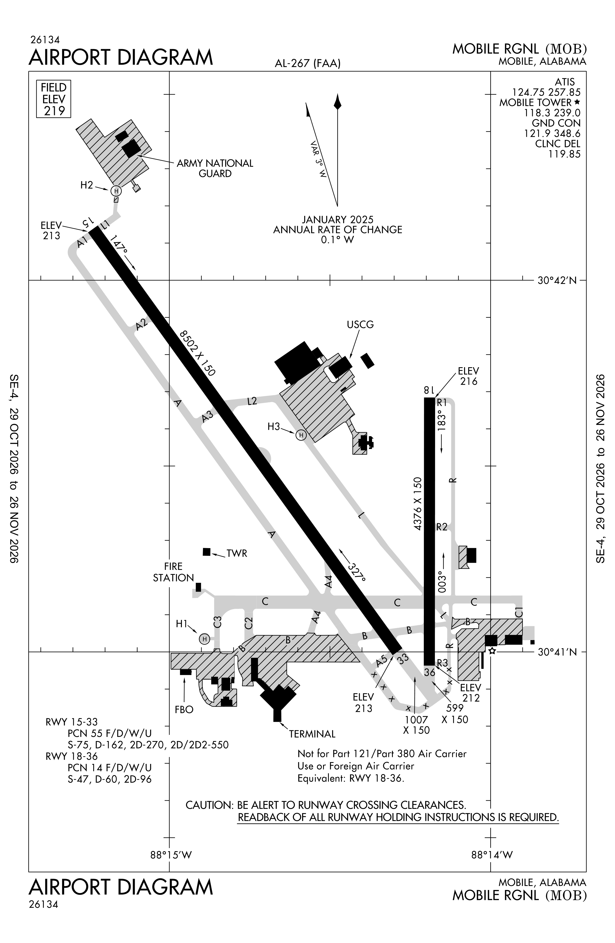
Official FAA PDF (effective Oct 29 to Nov 26)
FAA airport diagram, cycle 2611, effective Oct 29 to Nov 26, 2026. Reference only, not for navigation.
FBOs and services
FBOs
 Signature Mobile371 Flave Pierce Road, 8400 Airport Blvd, Mobile, AL 36608+1 251-633-5000Hours: 0500L - 2200L Call out available on requestUNICOM 122.95ARINC 130.225Signature pageSource: Signature Aviation
FBO locations from the operators' own sites, may be out of date. Call ahead to confirm services and hours.
Not listed? The FBO may not be in OpenStreetMap. Send a correction.
Signature Aviation locations, as of Nov 5, 2026.
Related
- Interactive NOTAM search for KMOB (category filters, maps, share links and a NOTAM decoder)
- Mobile Regional Airport: codes, map and current weather
- MOB weather and runway winds (METAR and TAF in plain English)
- Flights at MOB now
- NOTAMs for other US airports
More NOTAMs in Alabama
Times are UTC (Z). Plain-English explanations are generated by cwsi.net from the NOTAM abbreviations and may simplify; the original NOTAM text is authoritative. NOTAMs come from the FAA NOTAM Management Service; cwsi.net refreshes its copy every 3 minutes. cwsi.net is not affiliated with the FAA: always confirm NOTAMs through official sources (a standard briefing or FAA NOTAM Search) before flight.