BHM NOTAMs
Birmingham-Shuttlesworth International Airport, Birmingham, AL · KBHM
Birmingham-Shuttlesworth International Airport in Birmingham, Alabama (IATA BHM, ICAO KBHM) has 105 current NOTAMs (Notices to Air Missions): 101 in effect now and 4 starting later. By category: obstacles (80), taxiways (10) and procedures (8). The list comes from the FAA NOTAM Management Service, refreshed by cwsi.net every few minutes; each NOTAM shows its number, category, start and end time in UTC, and a plain-English reading.
- Obstacle80
- Taxiway10
- Procedures8
- Navaid3
- Apron2
- Runway2
In effect now (101)
TWY H4, H3, TWY H BTN AIR NTL GUARD APN AND HANGAR 26 APN CLSD 2611171545-2611180200
RWY 18 PAPI U/S 2611171113-2701202359
OBST TOWER LGT (ASR 1300774) 333058.30N0864504.70W (2.9NM S BHM) 1122.0FT (160.1FT AGL) U/S 2611170655-2612020555
TWY M CL MARKINGS BTN APCH END RWY 18 AND RWY 06/24 NOT STD 2611170058-2611222300
TWY M HLDG PSN MARKINGS FOR APCH END RWY 18 NOT STD 2611170055-2611222300
OBST CRANE (ASN 2026-ASO-7430-NRA) 333311N0864518W (0.7NM SSW BHM) 683FT (80FT AGL) FLAGGED AND LGTD 2611171400-2612090001
OBST CRANE (ASN 2026-ASO-7429-NRA) 333321N0864518W (0.5NM SSW BHM) 683FT (80FT AGL) FLAGGED AND LGTD 2611171400-2612090001
OBST TOWER LGT (ASR 1036582) 333306.00N0865439.00W (8NM W BHM) 952FT (213FT AGL) U/S 2611160418-2612310416
TWY H CL MARKINGS BTN TWY H2 AND TWY H3 OBSC 2611152348-2611302300
TWY H CL MARKINGS BTN AIR NTL GUARD APN AND TWY H4 REMOVED 2611152346-2611302300
TWY H EDGE MARKINGS BTN TWY H2 AND TWY H3 NOT STD 2611152346-2611302300
OBST TOWER LGT (ASR 1204184) 334621.20N0863720.00W (14.2NM NNE BHM) 1329.7FT (258.9FT AGL) U/S 2611151534-2702131534
RWY 36 RWY END ID LGT U/S 2611131118-2611252359
NAV ILS RWY 06 GP U/S 2611122050-2611302359
TWY A CL MARKINGS BTN RWY 18/36 AND TWY P NOT STD 2611091742-2612010001
OBST TOWER LGT (ASR 1009818) 334028.00N0865739.00W (12.3NM WNW BHM) 669.9FT (254.9FT AGL) U/S 2611091236-2702071236
OBST TOWER LGT (ASR 1036003) 332926.00N0864748.00W (5.0NM SSW BHM) 2048.9FT (1075.1FT AGL) U/S 2611031845-2612032359
OBST TOWER LGT (ASR 1017640) 332745.00N0865059.00W (7.8NM SW BHM) 1659FT (714FT AGL) U/S 2610230955-2612071054
OBST RIG (ASN 2025-ASO-4061-NRA) 333318N0864642W (1.4NM WSW BHM) 625FT (25FT AGL) FLAGGED AND LGTD 2610200031-2611252300
OBST RIG (ASN 2025-ASO-4051-NRA) 333325N0864619W (1.1NM WSW BHM) 618FT (15FT AGL) FLAGGED AND LGTD 2610200025-2611252300
OBST RIG (ASN 2025-ASO-4053-NRA) 333325N0864620W (1.1NM WSW BHM) 618FT (15FT AGL) FLAGGED AND LGTD 2610200025-2611252300
OBST RIG (ASN 2025-ASO-4052-NRA) 333325N0864620W (1.1NM WSW BHM) 618FT (15FT AGL) FLAGGED AND LGTD 2610200025-2611252300
OBST RIG (ASN 2025-ASO-4050-NRA) 333328N0864614W (1.0NM WSW BHM) 618FT (15FT AGL) FLAGGED AND LGTD 2610200024-2611252300
OBST RIG (ASN 2025-ASO-4049-NRA) 333327N0864616W (1.0NM WSW BHM) 617FT (15FT AGL) FLAGGED AND LGTD 2610200024-2611252300
OBST RIG (ASN 2025-ASO-4054-NRA) 333323N0864627W (1.2NM WSW BHM) 629FT (25FT AGL) FLAGGED AND LGTD 2610200026-2611252300
OBST RIG (ASN 2025-ASO-4057-NRA) 333324N0864628W (1.2NM WSW BHM) 633FT (25FT AGL) FLAGGED AND LGTD 2610200029-2611252300
OBST RIG (ASN 2025-ASO-4055-NRA) 333325N0864626W (1.2NM WSW BHM) 633FT (25FT AGL) FLAGGED AND LGTD 2610200029-2611252300
OBST RIG (ASN 2025-ASO-4059-NRA) 333318N0864641W (1.4NM WSW BHM) 629FT (25FT AGL) FLAGGED AND LGTD 2610200030-2611252300
OBST RIG (ASN 2025-ASO-4058-NRA) 333317N0864642W (1.4NM WSW BHM) 626FT (25FT AGL) FLAGGED AND LGTD 2610200030-2611252300
OBST RIG (ASN 2025-ASO-4060-NRA) 333319N0864642W (1.4NM WSW BHM) 627FT (25FT AGL) FLAGGED AND LGTD 2610200031-2611252300
OBST RIG (ASN 2025-ASO-4056-NRA) 333324N0864625W (1.2NM WSW BHM) 630FT (25FT AGL) FLAGGED AND LGTD 2610200029-2611252300
OBST RIG (ASN 2025-ASO-4038-NRA) 333326N0864625W (1.2NM WSW BHM) 623FT (15FT AGL) FLAGGED AND LGTD 2610200015-2611252300
OBST RIG (ASN 2025-ASO-4040-NRA) 333325N0864624W (1.1NM WSW BHM) 620FT (15FT AGL) FLAGGED AND LGTD 2610200016-2611252300
OBST RIG (ASN 2025-ASO-4041-NRA) 333329N0864618W (1.0NM WSW BHM) 620FT (15FT AGL) FLAGGED AND LGTD 2610200017-2611252300
OBST RIG (ASN 2025-ASO-4042-NRA) 333329N0864618W (1.0NM WSW BHM) 621FT (15FT AGL) FLAGGED AND LGTD 2610200018-2611252300
OBST RIG (ASN 2025-ASO-4043-NRA) 333328N0864620W (1.1NM WSW BHM) 620FT (15FT AGL) FLAGGED AND LGTD 2610200018-2611252300
OBST RIG (ASN 2025-ASO-4044-NRA) 333327N0864619W (1.1NM WSW BHM) 620FT (15FT AGL) FLAGGED AND LGTD 2610200019-2611252300
OBST RIG (ASN 2025-ASO-4046-NRA) 333325N0864619W (1.1NM WSW BHM) 618FT (15FT AGL) FLAGGED AND LGTD 2610200020-2611252300
OBST RIG (ASN 2025-ASO-4047-NRA) 333327N0864617W (1.0NM WSW BHM) 618FT (15FT AGL) FLAGGED AND LGTD 2610200023-2611252300
OBST RIG (ASN 2025-ASO-4048-NRA) 333327N0864616W (1.0NM WSW BHM) 618FT (15FT AGL) FLAGGED AND LGTD 2610200024-2611252300
Showing the 40 most recently issued. See all 101 with category filters.
Starting later (4)
APRON WEST FIXED BASE OPR APN SOUTHWEST ACCESS CLSD 2611190400-2611191000
TWY H BTN APCH END RWY 06 AND HANGAR 33 APN CLSD 2611190400-2611191000
TWY H BTN APCH END RWY 06 AND WEST FIXED BASE OPR APN SOUTHWEST ACCESS CLSD 2611190001-2611190400
TWY H4, H3, TWY H BTN AIR NTL GUARD APN AND HANGAR 26 APN CLSD 2611191800-2611200200
Airport diagram

FAA chart (PNG) Official FAA PDF (effective Oct 29 to Nov 26)
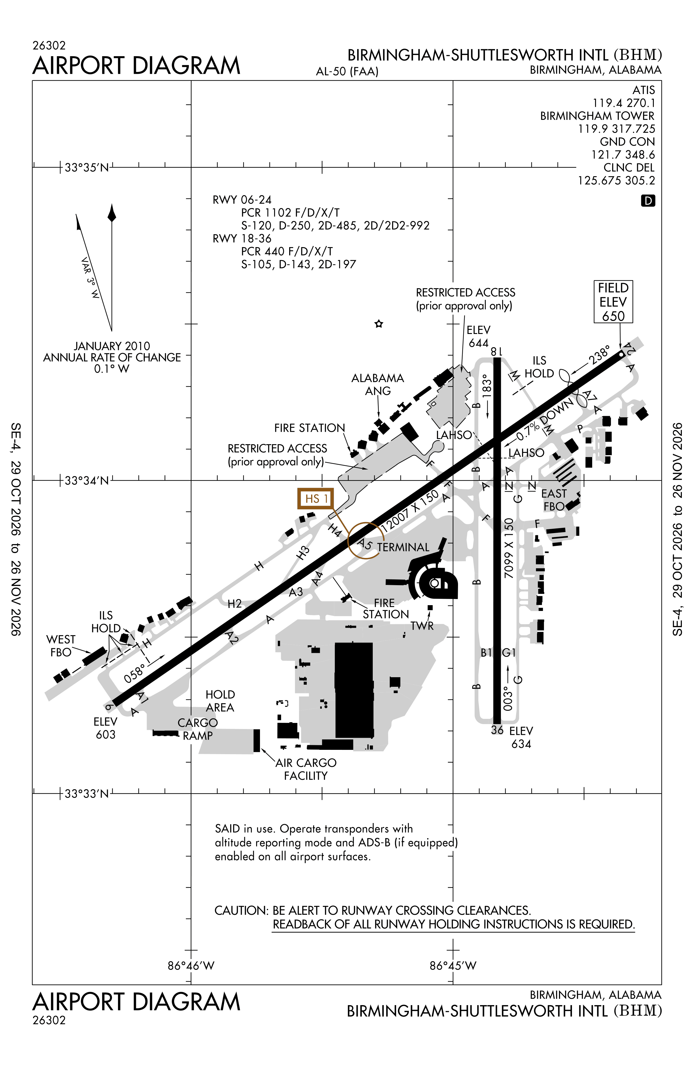
Redrawn by cwsi.net from the FAA airport diagram, cycle 2611, effective Oct 29 to Nov 26, 2026, and OpenStreetMap. Reference only, not for navigation.
FBOs and services
FBOs
 Atlantic Aviation Birmingham4243 E. Lake Blvd., Birmingham, AL+1 205-849-5520Hours: Mon-Sun: 24 HoursAtlantic page
 Million Air Birmingham4725 65th Place North Birmingham, AL 35206+1 659-223-3660Hours: 24/7Million Air page
FBO details may be out of date. Call ahead to confirm services and hours.
Not listed? Send a correction.
As of Nov 5, 2026.
Related
- Interactive NOTAM search for KBHM (category filters, maps, share links and a NOTAM decoder)
- Birmingham-Shuttlesworth International Airport: codes, map and current weather
- BHM weather and runway winds (METAR and TAF in plain English)
- Flights at BHM now
- NOTAMs for other US airports
More NOTAMs in Alabama
Times are UTC (Z). Plain-English explanations are generated by cwsi.net from the NOTAM abbreviations and may simplify; the original NOTAM text is authoritative. NOTAMs come from the FAA NOTAM Management Service; cwsi.net refreshes its copy every 3 minutes. cwsi.net is not affiliated with the FAA: always confirm NOTAMs through official sources (a standard briefing or FAA NOTAM Search) before flight.