MGM NOTAMs
Montgomery Regional Airport, Montgomery, AL · KMGM
Montgomery Regional Airport in Montgomery, Alabama (IATA MGM, ICAO KMGM) has 46 current NOTAMs (Notices to Air Missions): 34 in effect now and 12 starting later. By category: taxiways (25), obstacles (9) and runways (6). The list comes from the FAA NOTAM Management Service, refreshed by cwsi.net every few minutes; each NOTAM shows its number, category, start and end time in UTC, and a plain-English reading.
- Taxiway25
- Obstacle9
- Runway6
- Navaid2
- Apron1
- Procedures1
- Other2
In effect now (34)
RWY 03 HLDG PSN SIGN AT RWY 10/28 SE SIDE LGT U/S 2611041844-2611051330
RWY 10 HLDG PSN SIGN AT RWY 03/21 SW SIDE LGT U/S 2611020048-2612312300
TWY B TWY DIRECTION SIGN SOUTHWEST SIDE LGT U/S 2611020044-2612312300
TWY B BTN TWY E AND TWY B4 CLSD DLY 0530-1130 2611040530-2611071130
TWY A6 CLSD DLY 0530-1130 2611040530-2611071130
TWY B4 CLSD DLY 0530-1130 2611040530-2611071130
TWY B3 CLSD DLY 0530-1130 2611040530-2611071130
TWY A BTN TWY A1 AND RWY 03/21 CLSD DLY 0530-1130 2611040530-2611071130
TWY A BTN TWY A4 AND TWY A7 CLSD DLY 0530-1130 2611040530-2611071130
TWY A1 CLSD DLY 0530-1130 2611040530-2612111130
TWY A4 CLSD DLY 0530-1130 2611040530-2611071130
TWY B BTN RWY 03/21 AND TWY B1 CLSD 2610302135-2611071130
TWY B1 CLSD 2610302134-2611071130
TWY A7 CLSD 2610302133-2611071130
TWY A2 CLSD 2610302129-2611071130
TWY A BTN TWY A6 AND TWY A7 CLSD 2610302129-2611071130
RWY 10/28 CLSD DLY 0530-1130 2611040530-2611071130
M0076/26 NOTAMN Q) ZTL/QOLAS/IV/NBO/A/000/999/3218N08623W005 A) KMGM B) 2610301448 C) 2701271300 E) ALABAMA AIR NTL GUARD RAMP MULT OBS LTS U/S ADJ TO APRON AND TWY A
TWY A BTN TWY F AND TWY A7 CLSD DLY 0430-1030 2610310430-2611271030
OBST TOWER LGT (ASR 1034665) 321941.00N0861812.00W (4.9NM ENE MGM) 390.1FT (200.1FT AGL) U/S 2610270340-2702240340
OBST TOWER LGT (ASR 1026495) 321521.20N0863334.30W (8.9NM WSW MGM) 656.2FT (305.1FT AGL) U/S 2610250145-2702220145
OBST TOWER LGT (ASR 1304172) 321147.80N0862528.90W (6.4NM S MGM) 544FT (277FT AGL) U/S 2610211501-2612051501
OBST TOWER LGT (ASN 2025-ASO-19647-OE) 321102N0861713W (8.8NM SE MGM) 503FT (260FT AGL) U/S 2610190629-2612030613
M0072/26 NOTAMN Q) ZTL/QFFCG/IV/NBO/A/000/999/3218N08623W005 A) KMGM B) 2609302000 C) 2611301200 E) ARFF STATUS RED FOR MIL ACFT CAT 1-10. CLS MANNING. CIV ACFT NOT AFFECTED.
APRON ALABAMA AIR NTL GUARD RAMP CONST AREA ADJ N EDGE LGTD AND BARRICADED . REDUCED WT CLNC. CTC BASE OPS FOR TAXI/PARKING INSTRUCTIONS. 2609301949-2611301200
OBST TOWER LGT (ASR 1013359) 321942.00N0861612.00W (6.6NM ENE MGM) 425.9FT (219.8FT AGL) U/S 2609121418-2701101418
NAV MARRA NDB U/S 2609092003-2703092111EST
OBST TOWER LGT (ASR 1040403) 322204.10N0861542.00W (7.9NM ENE MGM) 1014.1FT (729.0FT AGL) U/S 2608312227-2611292327
OBST TOWER LGT (ASR 1000469) 321408.40N0860827.30W (13.4NM ESE MGM) 530.8FT (265.1FT AGL) U/S 2608181904-2611162004
OBST TOWER LGT (ASR 1039293) 320539.00N0862759.60W (13.0NM SSW MGM) 593.2FT (265.1FT AGL) U/S 2608151858-2611131958
OBST TOWER LGT (ASR 1000943) 322141.00N0861333.40W (9.4NM ENE MGM) 471.8FT (169.9FT AGL) U/S 2608121458-2611101558
TWY F WIP MEN AND HVY EQPT 2608111300-2702071400
NAV ILS RWY 10 OM U/S 2607091928-2612162359
IAP MONTGOMERY RGNL (DANNELLY FLD), MONTGOMERY, AL. NDB RWY 10, AMDT 19B... S-10 - MDA 760/HAT 541 ALL CATS , CATS C-D VISIBILITY RVR 6000. CIRCLING CATS A/B MDA 760/HAA 528, CAT C VISIBILITY 1 5/8. CHANGE NOTE TO READ: FOR INOP ALS INCREASE S-10 CATS A/B VISIBILITY TO RVR 5500 AND CATS C/D VISIBILITY TO 1 5/8 MILE. 2507091726-2707091726EST
Starting later (12)
RWY 03/21 CLSD 2611070530-2612211130
TWY B CLSD DLY 0530-1130 2611070530-2612211130
TWY A CLSD DLY 0530-1130 2611070530-2612211130
TWY C3 CLSD DLY 0530-1130 2611070530-2612211130
TWY C2 CLSD DLY 0530-1130 2611070530-2612211130
TWY C1 CLSD DLY 0530-1130 2611070530-2612211130
TWY F CLSD DLY 0530-1130 2611070530-2612211130
TWY E1 CLSD DLY 0530-1130 2611070530-2612211130
TWY E2 CLSD DLY 0530-1130 2611070530-2612211130
TWY E CLSD DLY 0530-1130 2611070530-2612211130
RWY 10/28 CLSD DLY 0530-1130 2611070530-2612211130
RWY 10/28 CLSD EXC MIL OPS 2611081330-2611081430
Airport diagram
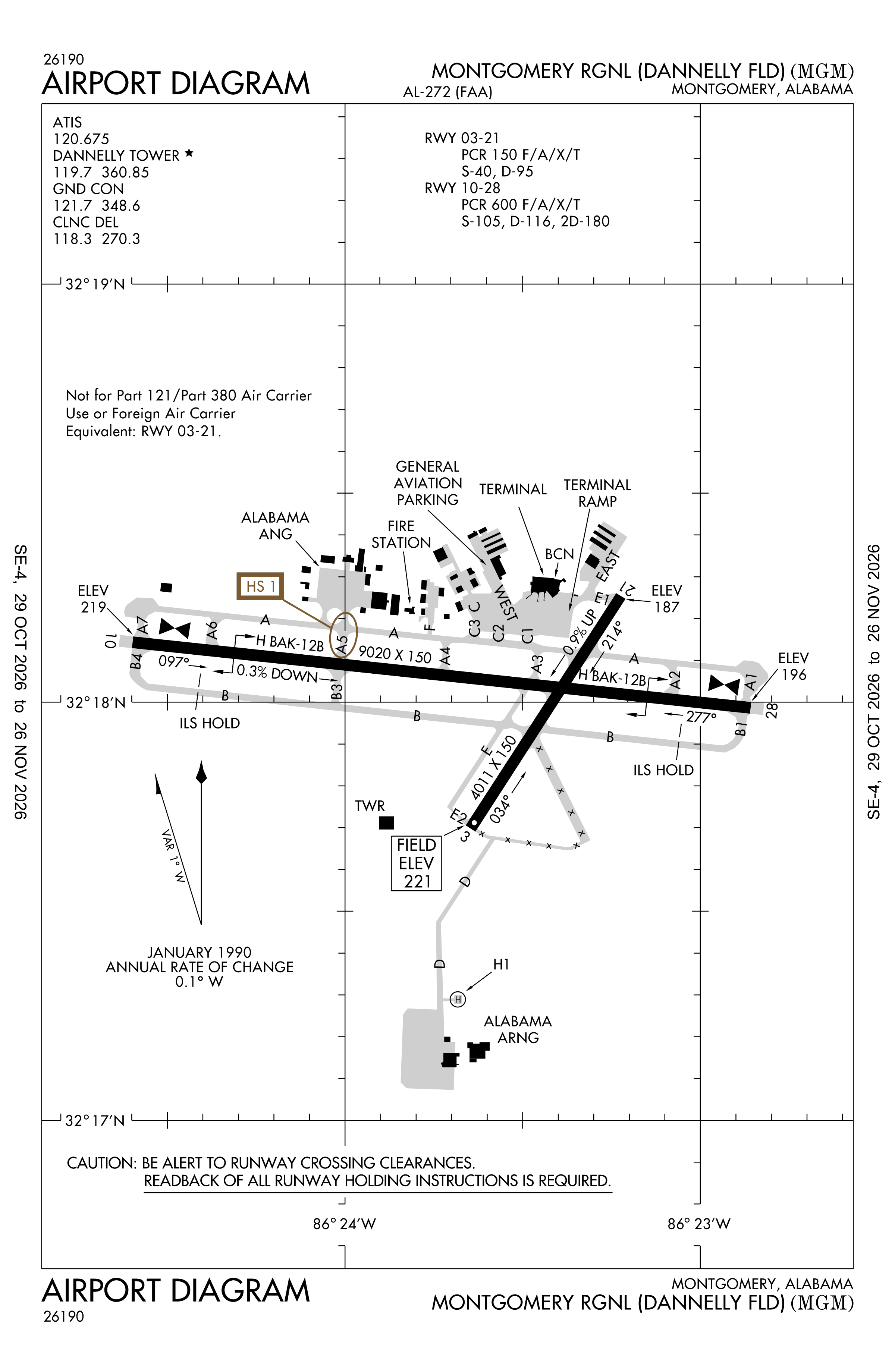
Official FAA PDF (effective Oct 29 to Nov 26)
FAA airport diagram, cycle 2611, effective Oct 29 to Nov 26, 2026. Reference only, not for navigation.
FBOs and services
FBOs
No FBOs are listed in OpenStreetMap for this airport.
Not listed? The FBO may not be in OpenStreetMap. Send a correction.
Data © OpenStreetMap contributors (ODbL), as of Nov 3, 2026.
Related
- Interactive NOTAM search for KMGM (category filters, maps, share links and a NOTAM decoder)
- Montgomery Regional Airport: codes, map and current weather
- MGM weather and runway winds (METAR and TAF in plain English)
- Flights at MGM now
- NOTAMs for other US airports
More NOTAMs in Alabama
Times are UTC (Z). Plain-English explanations are generated by cwsi.net from the NOTAM abbreviations and may simplify; the original NOTAM text is authoritative. NOTAMs come from the FAA NOTAM Management Service; cwsi.net refreshes its copy every 3 minutes. cwsi.net is not affiliated with the FAA: always confirm NOTAMs through official sources (a standard briefing or FAA NOTAM Search) before flight.