HSV NOTAMs
Huntsville International Airport, Huntsville, AL · KHSV
Huntsville International Airport in Huntsville, Alabama (IATA HSV, ICAO KHSV) has 26 current NOTAMs (Notices to Air Missions): 12 in effect now and 14 starting later. By category: runways (8), obstacles (5) and navaids (4). The list comes from the FAA NOTAM Management Service, refreshed by cwsi.net every few minutes; each NOTAM shows its number, category, start and end time in UTC, and a plain-English reading.
- Runway8
- Obstacle5
- Navaid4
- Procedures4
- Taxiway4
- Airspace1
In effect now (12)
OBST TOWER LGT (ASR 1222270) 342919.70N0863533.50W (12.6NM SE HSV) 1529.9FT (261.8FT AGL) U/S 2611161043-2703161043
OBST TOWER LGT (ASR 1287601) 343825.90N0864304.30W (2.8NM E HSV) 812.0FT (210.0FT AGL) U/S 2611151130-2612152300
OBST TOWER LGT (ASR 1254348) 344836.30N0865003.20W (10.7NM NNW HSV) 1023.0FT (266.1FT AGL) U/S 2611020147-2701310147
AIRSPACE UAS WI AN AREA DEFINED AS 1.5NM RADIUS OF 343757N0864755W (.8NM SSW HSV) SFC-400FT AGL 2610261806-2611302359
IAP HUNTSVILLE INTL-CARL T JONES FLD, HUNTSVILLE, AL. ILS OR LOC RWY 18L, AMDT 6... MISSED APPROACH: CLIMB TO 1400 THEN CLIMBING LEFT TURN TO 4000 ON HEADING 175 AND ON RQZ VORTAC R-195 TO ENIKY/RQZ 23.67 DME AND HOLD, CONTINUE CLIMB-IN-HOLD TO 4000. (DME REQUIRED), VUZ VOR OUT OF SERVICE. 2610021609-2701061609EST
TWY L WIP CONST NORTH SIDE EAST OF FUEL FARM 2609251556-2701292100
OBST TOWER LGT (ASR 1036710) 344621.20N0864930.70W (8.4NM NNW HSV) 1005.9FT (273.0FT AGL) U/S 2609012014-2611302114
RWY 18R/36L W 1000FT WIP HEAVY EQUIPMENT WEST OF RWY 18R APCH END 2608311200-2612312100EST
IAP HUNTSVILLE INTL-CARL T JONES FLD, HUNTSVILLE, AL. RNAV (GPS) RWY 18R, AMDT 3... LNAV/VNAV 1014/HAT 385 ALL CATS, VIS ALL CATS RVR 3500. CHANGE NOTE TO READ: FOR INOP ALS, INCREASE LPV CAT E VISIBILITY TO RVR 4000, LNAV/VNAV CAT E VISIBILITY TO RVR 6000, AND LNAV CAT E VISIBILITY TO 1 1/4 SM. TEMPORARY CRANE 203 MSL 2298FT SE OF RWY 18R (2025-ASO-6649-NRA). 2608031200-2612151128EST
IAP HUNTSVILLE INTL-CARL T JONES FLD, HUNTSVILLE, AL. RNAV (GPS) RWY 18L, AMDT 3... LNAV MDA 1120/HAT 511 ALL CATS, VIS CATS C/D/E RVR 5500. VDP NA. CHANGE NOTE TO READ: FOR INOP ALS, INCREASE LPV CAT E VISIBILITY TO RVR 4000, LNAV/VNAV CAT E VISIBILITY TO 1 3/8 SM, AND LNAV CAT C/D/E VISIBILITY TO 1 3/8 SM. TEMPORARY CRANE 203 MSL 3535FT SW OF RWY 18L (2025-ASO-6649-NRA). 2608031200-2612151128EST
OBST CRANE (ASN 2025-ASO-6649-NRA) 343856.04N0864633.88W (0.7NM N HSV) 803FT (189FT AGL) FLAGGED DLY SR-SS 2608031200-2611301200
RWY 18L/36R LEAD ON CL MARKING, LEAD OFF CL MARKING FOR TWY E2, C2 OBSC 2606271627-2612312300
Starting later (14)
SID HUNTSVILLE INTL-CARL T JONES FLD, HUNTSVILLE, AL. HUNTSVILLE FIVE DEPARTURE... SHELBYVILLE TRANSITION NA EXCEPT FOR ACFT EQUIPPED WITH SUITABLE RNAV SYSTEM WITH GPS, SYI VOR/DME OUT OF SERVICE. 2611171400-2611172000EST
NAV ILS RWY 18R CAT III NA 2611171400-2611172200
RWY 18R RVR U/S 2611171400-2611172200
NAV ILS RWY 18R U/S 2611181330-2611181900
RWY 18L/36R CLSD 2611171300-2611201400
TWY E BTN TWY E5 AND TWY E9 CLSD 2611171300-2611201400
TWY E1, E2, E3, E4, E6, E7, E8, E9, C, C1, C2, C3, C5, C6, C7 CLSD 2611171300-2611201400
TWY E BTN TWY E1 AND TWY F2 CLSD 2611171300-2611201400
RWY 18L PAPI U/S 2611171300-2611201500
RWY 36R PAPI U/S 2611171300-2611201500
RWY 36R ALS U/S 2611171300-2611201500
NAV ILS RWY 36R U/S 2611171300-2611201500
RWY 18L ALS U/S 2611171300-2611201500
NAV ILS RWY 18L U/S 2611171300-2611201500
Airport diagram

FAA chart (PNG) Official FAA PDF (effective Oct 29 to Nov 26)
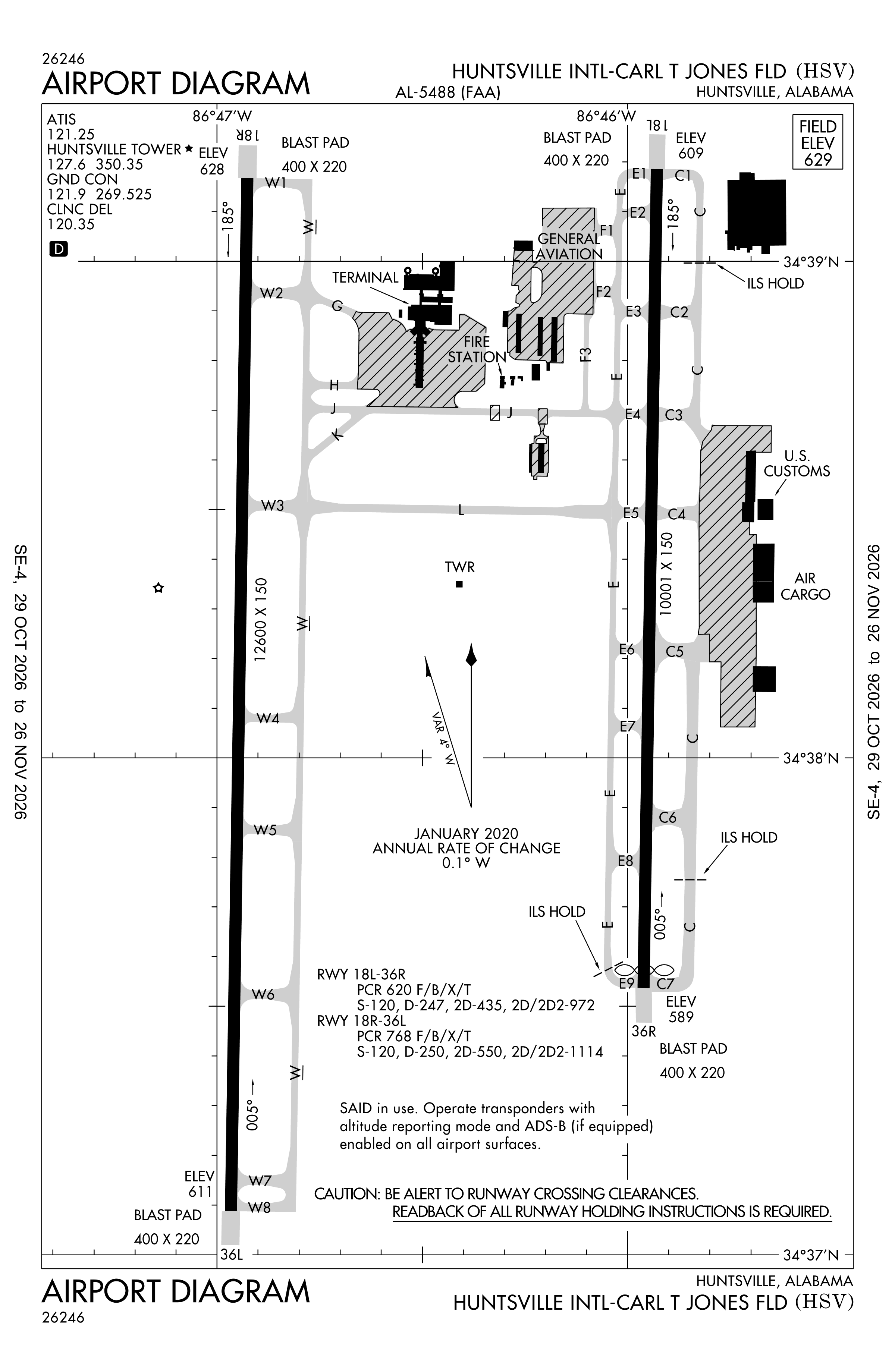
Redrawn by cwsi.net from the FAA airport diagram, cycle 2611, effective Oct 29 to Nov 26, 2026, and OpenStreetMap. Reference only, not for navigation.
FBOs and services
FBOs
 Signature Huntsville2000 Houston Goodson Way, Huntsville, AL 35824+1 256-772-9341Hours: 24 hours a day/7 days a weekARINC 130.375Signature page
FBO details may be out of date. Call ahead to confirm services and hours.
Not listed? Send a correction.
As of Nov 5, 2026.
Related
- Interactive NOTAM search for KHSV (category filters, maps, share links and a NOTAM decoder)
- Huntsville International Airport: codes, map and current weather
- HSV weather and runway winds (METAR and TAF in plain English)
- Flights at HSV now
- NOTAMs for other US airports
More NOTAMs in Alabama
Times are UTC (Z). Plain-English explanations are generated by cwsi.net from the NOTAM abbreviations and may simplify; the original NOTAM text is authoritative. NOTAMs come from the FAA NOTAM Management Service; cwsi.net refreshes its copy every 3 minutes. cwsi.net is not affiliated with the FAA: always confirm NOTAMs through official sources (a standard briefing or FAA NOTAM Search) before flight.