Airport Weather › OTH
OTH Weather: METAR, TAF and Runway Winds
Southwest Oregon Regional Airport, North Bend, OR · KOTH
Current weather at Southwest Oregon Regional Airport in North Bend, OR (IATA OTH, ICAO KOTH): the latest observation puts the airport in MVFR (marginal visual flight rules) conditions, wind 150° at 4 kt. Below are the latest METAR and TAF from the NOAA Aviation Weather Center, decoded into plain English, and the headwind and crosswind on each runway.
Weather radar
Current conditions (METAR)
- Wind: from the south-southeast (150° true) at 4 knots.
- Visibility: 10 miles or more.
- Weather: no rain, snow, fog or other weather reported.
- Clouds: few clouds at 500 ft, broken clouds at 2,300 ft, overcast at 3,200 ft; the ceiling is 2,300 ft above the ground.
- Temperature: 11°C (51°F), dew point 11°C (51°F).
- Altimeter: 30.27 inHg (1025 hPa).
METAR KOTH 051256Z AUTO 15004KT 10SM FEW005 BKN023 OVC032 11/11 A3027 RMK AO2 SLP250 T01060106 $
Runway winds
Components for the current wind, 150° at 4 kt. Headings are true, as METAR winds are; the most-headwind runway ends are marked, among runways at least half as long as the longest.
| Runway | Heading (true) | Headwind | Crosswind | Length |
|---|---|---|---|---|
| 05 | 061° | 0 kt | 4 kt from the right | 5,980 ft |
| 23 | 241° | 0 kt | 4 kt from the left | 5,980 ft |
| 13 Most headwind | 150° | 4 kt | 0 kt | 4,470 ft |
| 31 | 330° | Tailwind 4 kt | 0 kt | 4,470 ft |
Forecast (TAF)
Issued , valid to
TAF KOTH 051130Z 0512/0612 11007KT 3SM BR SCT004 OVC010 FM051800 12005KT P6SM SCT015 BKN120 FM052100 VRB04KT P6SM BKN250
- toWind 110° at 7 kt; visibility 3 miles; mist; scattered clouds at 400 ft, overcast at 1,000 ft.
- From (until )Wind 120° at 5 kt; visibility 6 miles or more; scattered clouds at 1,500 ft, broken clouds at 12,000 ft.
- From (until )Wind variable at 4 kt; visibility 6 miles or more; broken clouds at 25,000 ft.
Airport diagram
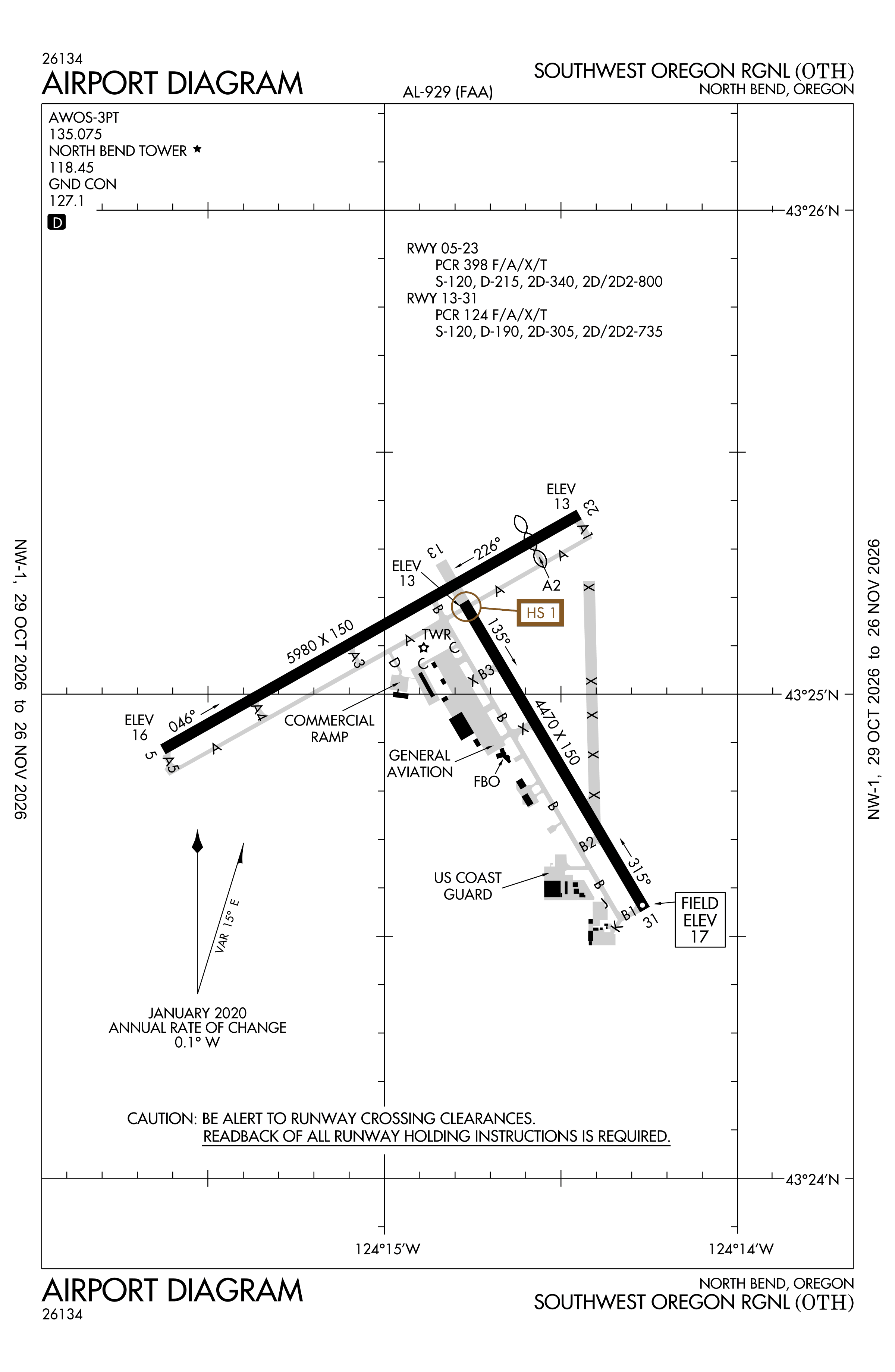
Official FAA PDF (effective Oct 29 to Nov 26)
FAA airport diagram, cycle 2611, effective Oct 29 to Nov 26, 2026. Reference only, not for navigation.
FBOs and services
FBOs
No FBOs are listed in OpenStreetMap for this airport.
Not listed? The FBO may not be in OpenStreetMap. Send a correction.
Data © OpenStreetMap contributors (ODbL), as of Nov 3, 2026.
Related
- KOTH weather with live refresh
- METAR and TAF decoder: read any report in plain English
- Southwest Oregon Regional Airport: codes, map and radar
- Current NOTAMs for OTH
- Flights at OTH now
- Weather for other airports
More airport weather in Oregon
Times are UTC (Z); the time after a slash is the local time at the airport. Weather and runway data come from the NOAA Aviation Weather Center (aviationweather.gov) and are refreshed here every few minutes; the plain-English summaries are generated by cwsi.net and may simplify, so the raw METAR and TAF are authoritative. Runway headings are true, worked out from NOAA's runway alignment. cwsi.net is not affiliated with NOAA or the FAA: get an official weather briefing before flight.