TLH NOTAMs
Tallahassee International Airport, Tallahassee, FL · KTLH
Tallahassee International Airport in Tallahassee, Florida (IATA TLH, ICAO KTLH) has 33 current NOTAMs (Notices to Air Missions): 33 in effect now and 0 starting later. By category: obstacles (12), runways (9) and taxiways (7). The list comes from the FAA NOTAM Management Service, refreshed by cwsi.net every few minutes; each NOTAM shows its number, category, start and end time in UTC, and a plain-English reading.
- Obstacle12
- Runway9
- Taxiway7
- Procedures2
- Apron1
- Navaid1
- Services1
In effect now (33)
SVC SSR U/S 2611171400-2611172300
OBST TOWER LGT (ASR 1001672) 302848.20N0840849.70W (11.8NM ENE TLH) 356.0FT (265.1FT AGL) U/S 2611161340-2702141340
OBST TOWER LGT (ASR 1004324) 302950.00N0840047.00W (18.7NM ENE TLH) 402.6FT (264.8FT AGL) U/S 2611152310-2702132310
OBST TOWER LGT (ASR 1064768) 302614.00N0842104.00W (2.4NM N TLH) 269FT (167FT AGL) U/S 2611130035-2611270035
OBST TOWER LGT (ASR 1026882) 303011.10N0835651.90W (22.1NM ENE TLH) 628.0FT (418.0FT AGL) U/S 2611110958-2703110958
OBST TOWER LGT (ASR 1029754) 302657.60N0841343.50W (7.2NM ENE TLH) 420.9FT (288.1FT AGL) U/S 2611070700-2702050700
OBST TOWER LGT (ASR 1037904) 302843.40N0840518.20W (14.6NM ENE TLH) 407.8FT (257.9FT AGL) U/S 2611031209-2702011209
OBST TOWER LGT (ASR 1200323) 302619.00N0842520.80W (4.4NM NW TLH) 380.2FT (242.1FT AGL) U/S 2610292259-2701272359
NAV ILS RWY 27 U/S 2610211418-2701292300
RWY 27 ALS U/S 2610211417-2701292300
RWY 27 RVRT U/S 2610211416-2701292300
OBST TOWER LGT (ASR 1231046) 301418.90N0841410.40W (11.0NM SSE TLH) 274.0FT (256.9FT AGL) U/S 2610151616-2701131716
OBST TOWER LGT (ASR 1056053) 302457.40N0841805.20W (2.8NM ENE TLH) 323.2FT (266.1FT AGL) U/S 2610011803-2612301903
OBST TOWER LGT (ASR 1030926) 302931.50N0841711.80W (6.7NM NNE TLH) 829.7FT (609.9FT AGL) U/S 2610011747-2612301847
RWY 09/27 CLSD EXC TAX BTN TWY B3 AND TWY B7 2610010954-2612312300
TWY A12 CL LGT DECOMMISSIONED 2610010942-PERM
RWY 18/36 CL MARKINGS OBSC 2610010936-2612312300
RWY 18/36 EDGE MARKINGS NOT STD 2610010937-2612312300
RWY 18 LEAD OFF CL MARKINGS OBSC 2610010937-2612312300
RWY 36 TDZ MARKINGS NOT STD 2610010939-2612312300
RWY 36 LEAD OFF CL MARKINGS OBSC 2610010938-2612312300
RWY 18 TDZ MARKINGS NOT STD 2610010938-2612312300
APRON TERMINAL RAMP WIP CONST 2610010936-2612312300
TWY B CL MARKINGS FOR APCH END RWY 36 NOT STD 2610010934-2612312300
TWY B3 NONMOVEMENT AREA 2610010933-2612312300
TWY B BTN TWY B3 AND TWY T2 CLSD 2610010932-2612312300
TWY B1, B2, B4, B6, B9, B10, T1 CLSD 2610010932-2612312300
TWY B BTN TWY A AND TWY B8 CLSD 2610010931-2612312300
TWY B BTN TWY B1 AND TWY B3 CLSD 2610010925-2612312300
IAP TALLAHASSEE INTL, TALLAHASSEE, FL. ILS RWY 27 (CAT II), AMDT 10E ... S-ILS 27 RA 154/DA 226/HAT 168 ALL CATS, VIS ALL CATS RVR 1600. TEMPORARY CRANE 188 MSL 4170FT NW OF RWY 27 (2022-ASO-6191-NRA). 2609241536-2705061536EST
OBST TOWER LGT (ASR 1004327) 302836.50N0835412.40W (23.9NM ENE TLH) 478.0FT (264.1FT AGL) U/S 2609170637-2612160737
OBST TOWER LGT (ASR 1028104) 303035.30N0841605.50W (8.1NM NNE TLH) 565.6FT (364.8FT AGL) U/S 2608221712-2612201712
IAP TALLAHASSEE INTL, TALLAHASSEE, FL. VOR OR TACAN RWY 36, AMDT 2... VOR PROCEDURE NA. NOTE: FC PROCEDURE NOT FLYABLE DUE TO COURSE SCALLOPING. 2601310041-2801300041EST
Airport diagram

FAA chart (PNG) Official FAA PDF (effective Oct 29 to Nov 26)
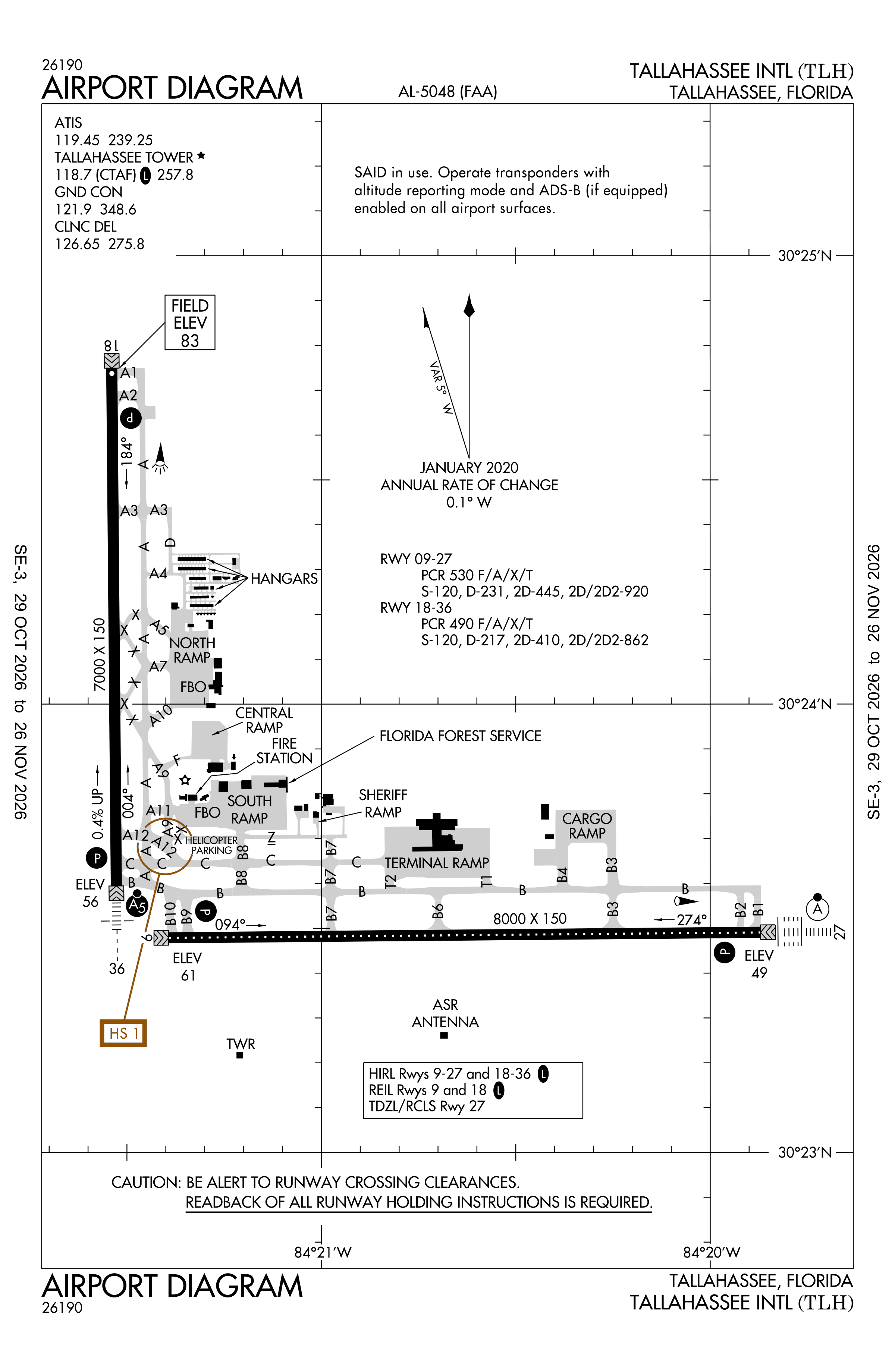
Redrawn by cwsi.net from the FAA airport diagram, cycle 2611, effective Oct 29 to Nov 26, 2026, and OpenStreetMap. Reference only, not for navigation.
FBOs and services
FBOs
 Million Air Tallahassee3254 Capital Circle SW Tallahassee, FL 32310+1 850-574-5671Hours: 24/7Million Air page
FBO details may be out of date. Call ahead to confirm services and hours.
Not listed? Send a correction.
As of Nov 13, 2026.
Related
- Interactive NOTAM search for KTLH (category filters, maps, share links and a NOTAM decoder)
- Tallahassee International Airport: codes, map and current weather
- TLH weather and runway winds (METAR and TAF in plain English)
- Flights at TLH now
- NOTAMs for other US airports
More NOTAMs in Florida
Times are UTC (Z). Plain-English explanations are generated by cwsi.net from the NOTAM abbreviations and may simplify; the original NOTAM text is authoritative. NOTAMs come from the FAA NOTAM Management Service; cwsi.net refreshes its copy every 3 minutes. cwsi.net is not affiliated with the FAA: always confirm NOTAMs through official sources (a standard briefing or FAA NOTAM Search) before flight.