FLL NOTAMs
Fort Lauderdale-Hollywood International Airport, Fort Lauderdale, FL · KFLL
Fort Lauderdale-Hollywood International Airport in Fort Lauderdale, Florida (IATA FLL, ICAO KFLL) has 67 current NOTAMs (Notices to Air Missions): 62 in effect now and 5 starting later. By category: procedures (21), taxiways (21) and runways (10). The list comes from the FAA NOTAM Management Service, refreshed by cwsi.net every few minutes; each NOTAM shows its number, category, start and end time in UTC, and a plain-English reading.
- Procedures21
- Taxiway21
- Runway10
- Obstacle6
- Communications4
- Navaid2
- Aerodrome1
- Apron1
- Services1
In effect now (62)
TWY A SAFETY AREA BTN TWY A6 AND TWY A8 N SIDE NOT STD RUTS 2611131854-2612112200
NAV VOR NOT MNT 2611131604-2612042000EST
RWY 28R RTHL U/S 2611131520-2611182000EST
NAV ILS RWY 28L DME NOT MNT 2611131514-2611252000
COM REMOTE TRANS/REC 133.725 U/S 2611121336-2611252000EST
COM REMOTE TRANS/REC 119.700 U/S 2611111458-2611182000EST
TWY A7, A8, B11, B12, Q NORTH, Q SOUTH RWY ENTRANCE LGT FOR RWY 10L U/S 2611061727-2612302000EST
TWY B CL MARKINGS BTN TWY B8 AND TWY B9 NOT STD 2611060654-2612312359EST
RWY 10R/28L ALL LEAD OFF LINES OBSC 2611010543-2612012300EST
RWY 28L CHEVRON SFC MARKING OBSC 2611010543-2612012330EST
RWY 10L/28R ALL LEAD OFF LINES OBSC 2611010530-2612012300EST
RWY 10R CHEVRON SFC MARKINGS OBSC 2611010532-2612011200EST
RWY 10L/28R CL MARKINGS OBSC 2611010534-2612012300EST
RWY 10R/28L CL MARKINGS OBSC 2611010535-2612012300EST
OBST POLE (ASN UNKNOWN) 260406N0800757W (0.18NM NNE APCH END RWY 28L) UNKNOWN (50FT AGL) NOT LGTD 2610310458-2611302359
TWY J1 CL MARKINGS OBSC 2610310459-2611302359EST
OBST STACK LGT (ASN 2013-ASO-9866-OE) 260509N0800732W (1.6NM ENE FLL) 165FT (149FT AGL) U/S 2610302107-2611302359
TWY B CL MARKINGS BTN TWY C4 AND TWY E NOT STD 2610230554-2611302359EST
OBST POLE (ASN UNKNOWN) 260407N0800811W (.22NM NW APCH END RWY 28L) UNKNOWN (100FT AGL) NOT LGTD 2610200543-2612312359
OBST POLE (ASN UNKNOWN) 260410N0800757W (.25NM NNE APCH END RWY 28L) UNKNOWN (100FT AGL) NOT LGTD 2610170416-2612312359
OBST POLE (ASN UNKNOWN) 260443N0800905W (.57NM NW APCH END RWY 28R) UNKNOWN (35FT AGL) NOT LGTD 2610120501-2612312359
IAP FORT LAUDERDALE/HOLLYWOOD INTL, FORT LAUDERDALE, FL. ILS OR LOC RWY 10L, AMDT 25... NOTE: AUTOPILOT COUPLED APPROACH NA BELOW 203. 2610021520-2705141520EST
APRON TXL T BTN GATE G3 AND GATE G12 EDGE MARKINGS NOT STD REMOVED 2609280501-2612312359
TWY J1 SFC PAINTED HLDG PSN SIGNS FOR APCH END RWY 10R NOT STD 2609280500-2612311200EST
TWY A CL MARKINGS BTN FEDEX RAMP AND AEROTERM RAMP EAST REMOVED 2609241915-2612041030
TWY A EDGE LGT BTN FEDEX RAMP AND AEROTERM RAMP EAST U/S 2609231203-2612041030
TWY A BTN FEDEX RAMP AND AEROTERM RAMP EAST CLSD 2609231159-2612041030
TWY A TWY DIRECTION SIGN EAST SIDE FOR NTL JETS RAMP NOT STD 2609171809-2611241030
TWY A TWY DIRECTION SIGN FOR AEROTERM RAMP EAST NOT STD 2609171702-2612241030
TWY Q TWY DIRECTION SIGN NORTHWEST SIDE FOR RWY 10L/28R MISSING 2609161504-2611241030
TWY A EDGE MARKINGS FOR EMBRAER RAMP EAST SIDE NOT STD 2609161503-2612241030EST
TWY A EDGE LGT AT EMBRAER RAMP NOT STD 2609161504-2612241030EST
TWY A SFC MARKINGS BTN AEROTERM RAMP WEST AND TWY A8 NOT STD 2609161459-2612241030
TWY A5 HLDG PSN MARKINGS FOR RWY 10L/28R NOT STD 2609161457-2612241030
RWY 28R TWY DIRECTION SIGN AT TWY Q RIGHT SIDE NOT STD 2609160605-2611241000
RWY 10L TWY DIRECTION SIGN AT TWY Q LEFT SIDE NOT STD 2609160604-2611241000
TWY Q EDGE LGT BTN RWY 10L/28R AND TWY A U/S 2609160553-2611241000
TWY Q CL MARKINGS BTN RWY 10L/28R AND TWY A REMOVED 2609160550-2611241000
TWY Q BTN RWY 10L/28R AND TWY A CLSD 2609160523-2611241000
OBST POLE (ASN UNKNOWN) 260436N0800801W (.39NM E APCH END RWY 28R) UNKNOWN (20FT AGL) NOT LGTD 2609150942-2612312359
Showing the 40 most recently issued. See all 62 with category filters.
Starting later (5)
AD AP RWY STATUS LGT SYSTEM U/S 2611170300-2611171130
COM REMOTE TRANS/REC 133.725, 306.300, 119.700 U/S 2611170300-2611171100
RWY 10L RVR U/S 2611170300-2611171100
COM CPDLC U/S 2611170300-2611171100
SVC ATIS U/S 2611170300-2611171100
Airport diagram

FAA chart (PNG) Official FAA PDF (effective Oct 29 to Nov 26)
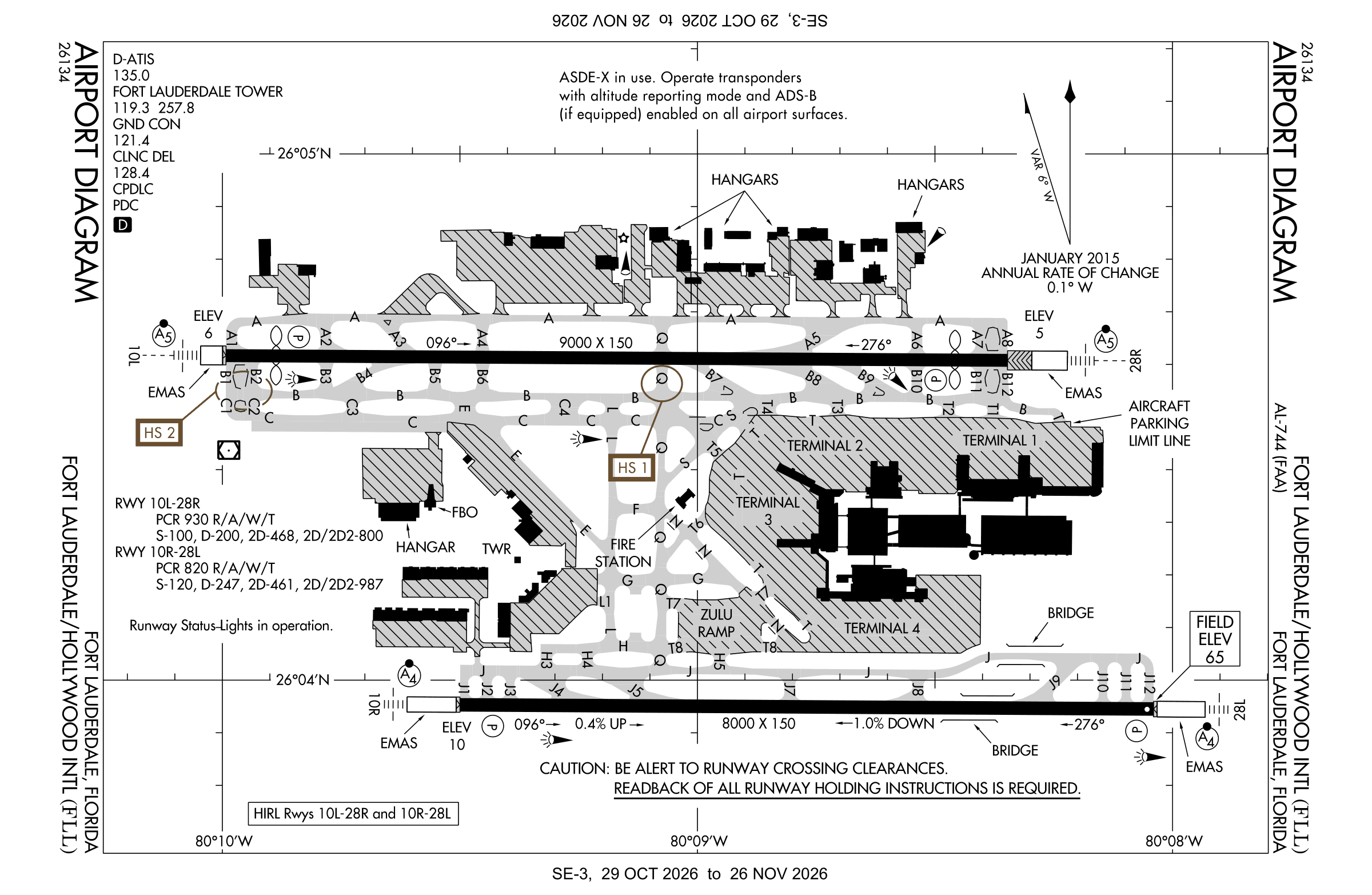
Redrawn by cwsi.net from the FAA airport diagram, cycle 2611, effective Oct 29 to Nov 26, 2026, and OpenStreetMap. Reference only, not for navigation.
FBOs and services
FBOs
 Signature Fort Lauderdale Hollywood4050 SW 11th Terrace, Fort Lauderdale, FL 33315+1 954-359-0000Hours: 24 hours a day/7 days a weekARINC 129.72Signature page
- SheltairBrand website
FBO details may be out of date. Call ahead to confirm services and hours.
Not listed? Send a correction.
As of Nov 3, 2026.
Related
- Interactive NOTAM search for KFLL (category filters, maps, share links and a NOTAM decoder)
- Fort Lauderdale-Hollywood International Airport: codes, map and current weather
- FLL weather and runway winds (METAR and TAF in plain English)
- Airport lounges at FLL by terminal
- Flights at FLL now
- NOTAMs for other US airports
More NOTAMs in Florida
Times are UTC (Z). Plain-English explanations are generated by cwsi.net from the NOTAM abbreviations and may simplify; the original NOTAM text is authoritative. NOTAMs come from the FAA NOTAM Management Service; cwsi.net refreshes its copy every 3 minutes. cwsi.net is not affiliated with the FAA: always confirm NOTAMs through official sources (a standard briefing or FAA NOTAM Search) before flight.