LAL NOTAMs
Lakeland Linder International Airport, Lakeland, FL · KLAL
Lakeland Linder International Airport in Lakeland, Florida (IATA LAL, ICAO KLAL) has 23 current NOTAMs (Notices to Air Missions): 23 in effect now and 0 starting later. By category: airspace (8), obstacles (5) and taxiways (5). The list comes from the FAA NOTAM Management Service, refreshed by cwsi.net every few minutes; each NOTAM shows its number, category, start and end time in UTC, and a plain-English reading.
- Airspace8
- Obstacle5
- Taxiway5
- Navaid2
- Runway2
- Aerodrome1
In effect now (23)
NAV ILS RWY 10 CAT II/III NA 2611051300-2611051900
AD AP RVR ALL U/S 2611051300-2611051900
AIRSPACE UAS WI AN AREA DEFINED AS .5NM RADIUS OF 280314N0821606W (5NM NE VDF) SFC-100FT AGL 2611051200-2611052100
OBST ANTENNA LGT (ASN UNKNOWN) 275946N0820114W (0.5NM NNE LAL) UNKNOWN (80FT AGL) U/S 2611010224-2611272100EST
TWY E1 CL MARKINGS NOT STD 2610310804-2611272100EST
TWY B CL MARKINGS FOR RWY 10/28 OBSC 2610310802-2611272100EST
RWY 10/28 CL MARKINGS OBSC 2610310802-2611272100EST
RWY 10/28 RCLL NOT STD 2610310803-2611272100EST
TWY B CL MARKINGS BTN RWY 10/28 AND TWY A OBSC 2610270914-2611202100EST
TWY A CL MARKINGS BTN TWY J AND RWY 05/23 OBSC 2610270914-2611202100EST
TWY A BTN TWY A3 AND TWY H CLSD 2610261214-2701312200
NAV ILS RWY 10 CAT II NA 2610260819-2611132000EST
AIRSPACE UAS WI AN AREA DEFINED AS 1.2NM RADIUS OF 274406N0821613W (14.8NM ENE 48X) SFC-225FT AGL 2610210448-2701312359
AIRSPACE UAS WI AN AREA DEFINED AS 1.2NM RADIUS OF 274512N0820951W (12.5NM SSW X49) SFC-225FT AGL 2610210448-2701312359
OBST POLE (ASN UNKNOWN) 280201N0820327W (2.95NM NNW APCH END RWY 10) UNKNOWN (180FT AGL) FLAGGED 2610151949-2611162100
AIRSPACE UAS WI AN AREA DEFINED AS 1NM RADIUS OF 274612N0821400W (14NM SW X49) SFC-225FT AGL 2610151614-2612312359
OBST TOWER LGT (ASR 1048950) 275956.30N0820144.80W (0.9NM NW LAL) 258.2FT (122.0FT AGL) U/S 2610121610-2701100400
AIRSPACE UAS WI AN AREA DEFINED AS 3NM RADIUS OF 274726N0815203W (10.5NM SW BOW) UNKNOWN (400FT) U/S 2609291522-2612312359
AIRSPACE UAS WI AN AREA DEFINED AS 1.3NM RADIUS OF 273950N0815747W (8.9NM NW CHN) SFC-225FT AGL 2609281644-2612312359
OBST TOWER LGT (ASR 1026391) 275628.00N0815520.00W (5.8NM ESE LAL) 700.8FT (481.0FT AGL) U/S 2609220721-2612210821
OBST TOWER LGT (ASR 1214779) 280733.20N0820205.50W (8.3NM N LAL) 346.8FT (230.0FT AGL) U/S 2609010006-2612300006
AIRSPACE UAS WI AN AREA DEFINED AS 1.4NM RADIUS OF 274819N0814321W (7.4NM SW X07) SFC-400FT AGL 2608031701-2612312359
AIRSPACE PJE WI AN AREA DEFINED AS 5NM RADIUS OF LAL338015.5 SFC-15000FT DLY SR-SS 2608041052-2701010017
Airport diagram
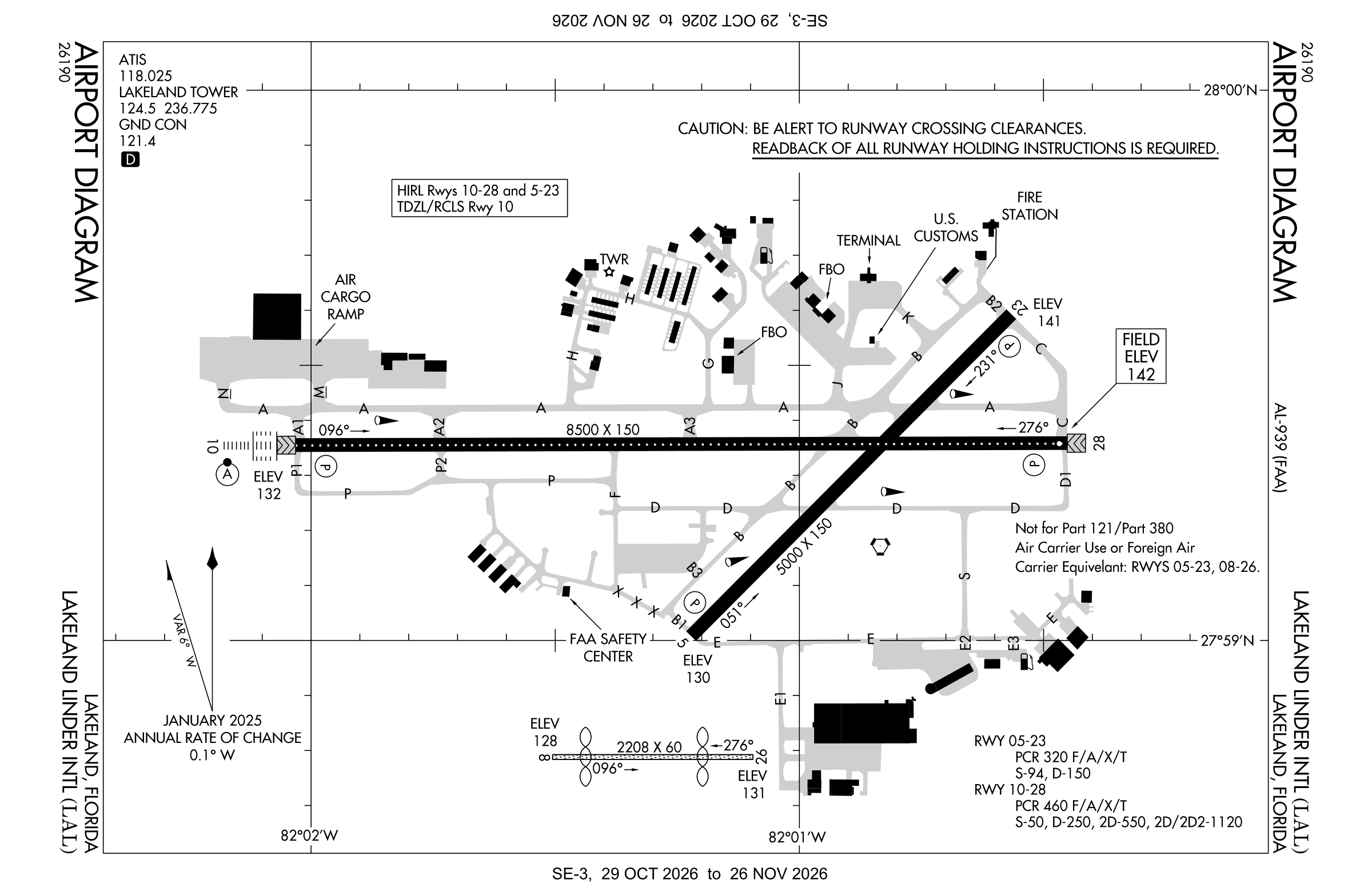
Official FAA PDF (effective Oct 29 to Nov 26)
FAA airport diagram, cycle 2611, effective Oct 29 to Nov 26, 2026. Reference only, not for navigation.
FBOs and services
FBOs
- Sheltair 2 locations at this airportBrand websiteFuel (OpenStreetMap): Jet A, 100LL
FBO locations from OpenStreetMap, community-maintained and may be out of date. Call ahead to confirm services and hours.
Not listed? The FBO may not be in OpenStreetMap. Send a correction.
Data © OpenStreetMap contributors (ODbL), as of Nov 3, 2026.
Related
- Interactive NOTAM search for KLAL (category filters, maps, share links and a NOTAM decoder)
- Lakeland Linder International Airport: codes, map and current weather
- LAL weather and runway winds (METAR and TAF in plain English)
- Flights at LAL now
- NOTAMs for other US airports
More NOTAMs in Florida
Times are UTC (Z). Plain-English explanations are generated by cwsi.net from the NOTAM abbreviations and may simplify; the original NOTAM text is authoritative. NOTAMs come from the FAA NOTAM Management Service; cwsi.net refreshes its copy every 3 minutes. cwsi.net is not affiliated with the FAA: always confirm NOTAMs through official sources (a standard briefing or FAA NOTAM Search) before flight.