SLE NOTAMs
McNary Field, Salem, OR · KSLE
McNary Field in Salem, Oregon (IATA SLE, ICAO KSLE) has 8 current NOTAMs (Notices to Air Missions): 7 in effect now and 1 starting later. By category: procedures (5), aerodromes (1) and aprons (1). The list comes from the FAA NOTAM Management Service, refreshed by cwsi.net every few minutes; each NOTAM shows its number, category, start and end time in UTC, and a plain-English reading.
- Procedures5
- Aerodrome1
- Apron1
- Obstacle1
In effect now (7)
OBST TOWER LGT (ASR 1035279) 445538.60N1225904.90W (1.3NM NE SLE) 352.0FT (132.9FT AGL) U/S 2611031652-2702011652
APRON AIR CARRIER RAMP CLSD 2610292055-2612112300
SID MCNARY FLD, SALEM, OR. SALEM FOUR DEPARTURE... LOST COMMUNICATIONS PROCEDURE: TAKEOFF RUNWAY 31 AND 34 NA EXCEPT FOR AIRCRAFT EQUIPPED WITH SUITABLE RNAV SYSTEM WITH GPS, UBG VOR OUT OF SERVICE. 2610021754-2705141754EST
IAP MCNARY FLD, SALEM, OR. ILS OR LOC Z RWY 31, AMDT 32... AUTOPILOT COUPLED APPROACH NA BELOW 1138FT MSL. 2604161221-2804161221EST
ODP MCNARY FLD, SALEM, OR. TAKEOFF MINIMUMS AND (OBSTACLE) DEPARTURE PROCEDURES AMDT 10... TAKE-OFF MINIMUMS RWY 13, 300-1 1/4 WITH MINIMUM CLIMB OF 265 FEET PER NM TO 4000, OR STANDARD WITH MINIMUM CLIMB OF 330 FT PER NM TO 2600, OR 2400-3 FOR VCOA. ALL OTHER DATA REMAINS AS PUBLISHED. 2503311325-2703282359EST
SID MCNARY FLD, SALEM, OR. SALEM FOUR DEPARTURE... TAKE-OFF MINIMUMS: RWY 13, STANDARD WITH MINIMUM CLIMB OF 330 FT PER NM TO 1100, OR 1500 - 2 1/2 FOR VCOA. TAKE-OFF MINIMUMS: RWY 16, 400 - 2 1/2 WITH MINIMUM CLIMB OF 260 FT PER NM TO 1100, OR 1500 - 2 1/2 FOR VCOA. ALL OTHER DATA REMAINS AS PUBLISHED. 2503261457-2703261457EST
IAP MCNARY FLD, SALEM, OR. RNAV (GPS) RWY 31, AMDT 3D... LNAV VISIBILITY CAT A RVR 2400, CAT B RVR 4000. WHEN LOCAL ALTIMETER SETTING NOT RECEIVED, USE MCMINNVILLE ALTIMETER SETTING AND INCREASE LPV DA TO 459 FEET; INCREASE LNAV/VNAV DA TO 936 FEET AND ALL VISIBILITIES 1/8 SM. INCREASE ALL MDAS 60 FEET AND LNAV VISIBILITY CAT C/D 1/8 SM, AND CIRCLING VISIBILITY CAT A AND CAT C 1/4 SM. FOR INOPERATIVE ALS WHEN USING MCMINNVILLE ALTIMETER SETTING, INCREASE LNAV/VNAV VISIBILITY ALL CATS TO 2. ALTERNATE MINIMUMS: CAT A/B: 900-2; CAT C: 900-2 1/2; CAT D: 1100-3. 2503171446-2703171446EST
Starting later (1)
AD AP RVR ALL U/S 2611101530-2611110300
Airport diagram
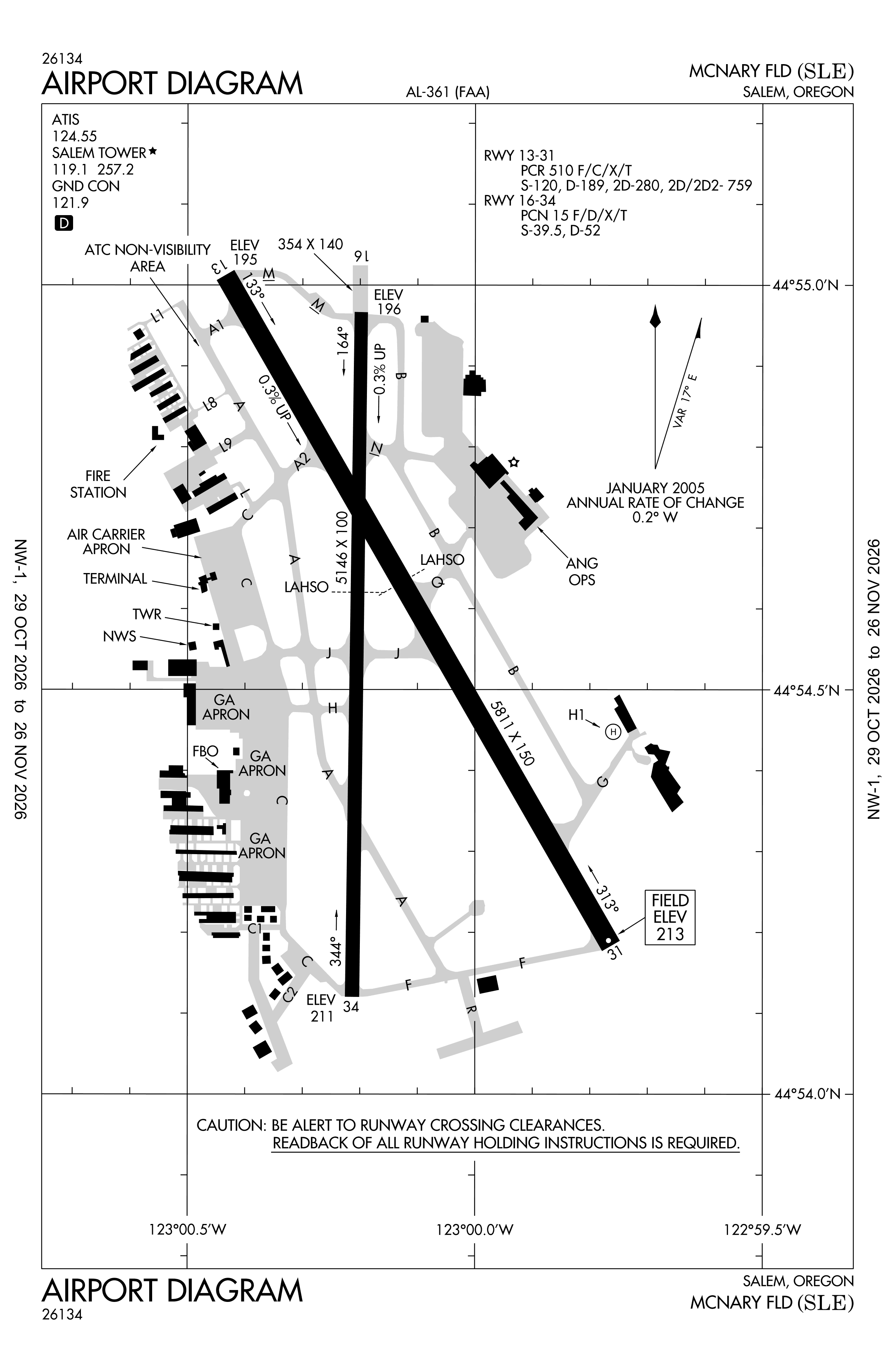
Official FAA PDF (effective Oct 29 to Nov 26)
FAA airport diagram, cycle 2611, effective Oct 29 to Nov 26, 2026. Reference only, not for navigation.
FBOs and services
FBOs
No FBOs are listed in OpenStreetMap for this airport.
Not listed? The FBO may not be in OpenStreetMap. Send a correction.
Data © OpenStreetMap contributors (ODbL), as of Nov 3, 2026.
Related
- Interactive NOTAM search for KSLE (category filters, maps, share links and a NOTAM decoder)
- McNary Field: codes, map and current weather
- SLE weather and runway winds (METAR and TAF in plain English)
- Flights at SLE now
- NOTAMs for other US airports
More NOTAMs in Oregon
Times are UTC (Z). Plain-English explanations are generated by cwsi.net from the NOTAM abbreviations and may simplify; the original NOTAM text is authoritative. NOTAMs come from the FAA NOTAM Management Service; cwsi.net refreshes its copy every 3 minutes. cwsi.net is not affiliated with the FAA: always confirm NOTAMs through official sources (a standard briefing or FAA NOTAM Search) before flight.