ROC NOTAMs
Frederick Douglass Greater Rochester International Airport, Rochester, NY · KROC
Frederick Douglass Greater Rochester International Airport in Rochester, New York (IATA ROC, ICAO KROC) has 18 current NOTAMs (Notices to Air Missions): 15 in effect now and 3 starting later. By category: obstacles (8), runways (4) and navaids (3). The list comes from the FAA NOTAM Management Service, refreshed by cwsi.net every few minutes; each NOTAM shows its number, category, start and end time in UTC, and a plain-English reading.
- Obstacle8
- Runway4
- Navaid3
- Airspace1
- Apron1
- Taxiway1
In effect now (15)
RWY 28 FICON 10 PCT WET OBS AT 2611161455. 2611161455-2611171455
RWY 22 FICON 10 PCT WET OBS AT 2611161453. 2611161453-2611171453
RWY 25 FICON 10 PCT WET OBS AT 2611161446. 2611161446-2611171446
TWY ALL FICON PATCHY WET OBS AT 2611161439. 2611161439-2611171439
APRON ALL FICON PATCHY WET OBS AT 2611161437. 2611161437-2611171437
OBST TOWER LGT (ASR 1011757) 430807.00N0773502.00W (4.0NM ENE ROC) 1030.8FT (357.9FT AGL) U/S 2611111530-2701151600
OBST TOWER LGT (ASR 1055024) 431037.00N0772838.00W (9.2NM E ROC) 1006FT (466FT AGL) U/S 2611050718-2612200716
OBST TOWER LGT (ASR 1002817) 430538.20N0773637.10W (3.1NM ESE ROC) 823.2FT (283.1FT AGL) U/S 2610310506-2612150603
OBST TOWER LGT (ASR UNKNOWN) 425830.06N0771307.00W (6.1NM NE IUA) 765FT (196FT AGL) U/S 2610281306-2701262359
RWY 10 DECLARED DIST: TORA 6402FT TODA 6402FT ASDA 5527FT LDA 5227FT. 2610221200-2705302359
OBST TOWER LGT (ASR 1003957) 430600.00N0773424.00W (4.4NM ESE ROC) 692.3FT (203.4FT AGL) U/S 2610221142-2701222359
OBST TOWER LGT (ASR 1003956) 430602.00N0773424.00W (4.4NM ESE ROC) 692.3FT (203.4FT AGL) U/S 2610221141-2701222359
OBST TOWER LGT (ASR 1003955) 430602.00N0773420.00W (4.5NM ESE ROC) 692.3FT (203.4FT AGL) U/S 2610221141-2701222359
OBST TOWER LGT (ASR 1003954) 430600.00N0773420.00W (4.5NM ESE ROC) 692.3FT (203.4FT AGL) U/S 2610221140-2701222359
AIRSPACE UAS WI AN AREA DEFINED AS 3NM RADIUS OF 430102.20N0780358.10W (4.6NM ESE GVQ) SFC-250FT AGL DLY 0000-2359 2608150000-2708142359
Starting later (3)
NAV ILS RWY 04 U/S 2611171230-2611172000
NAV ILS RWY 22 U/S 2611171230-2611172000
NAV ILS RWY 04 LOC U/S 2611181200-2611181500
Airport diagram

FAA chart (PNG) Official FAA PDF (effective Oct 29 to Nov 26)
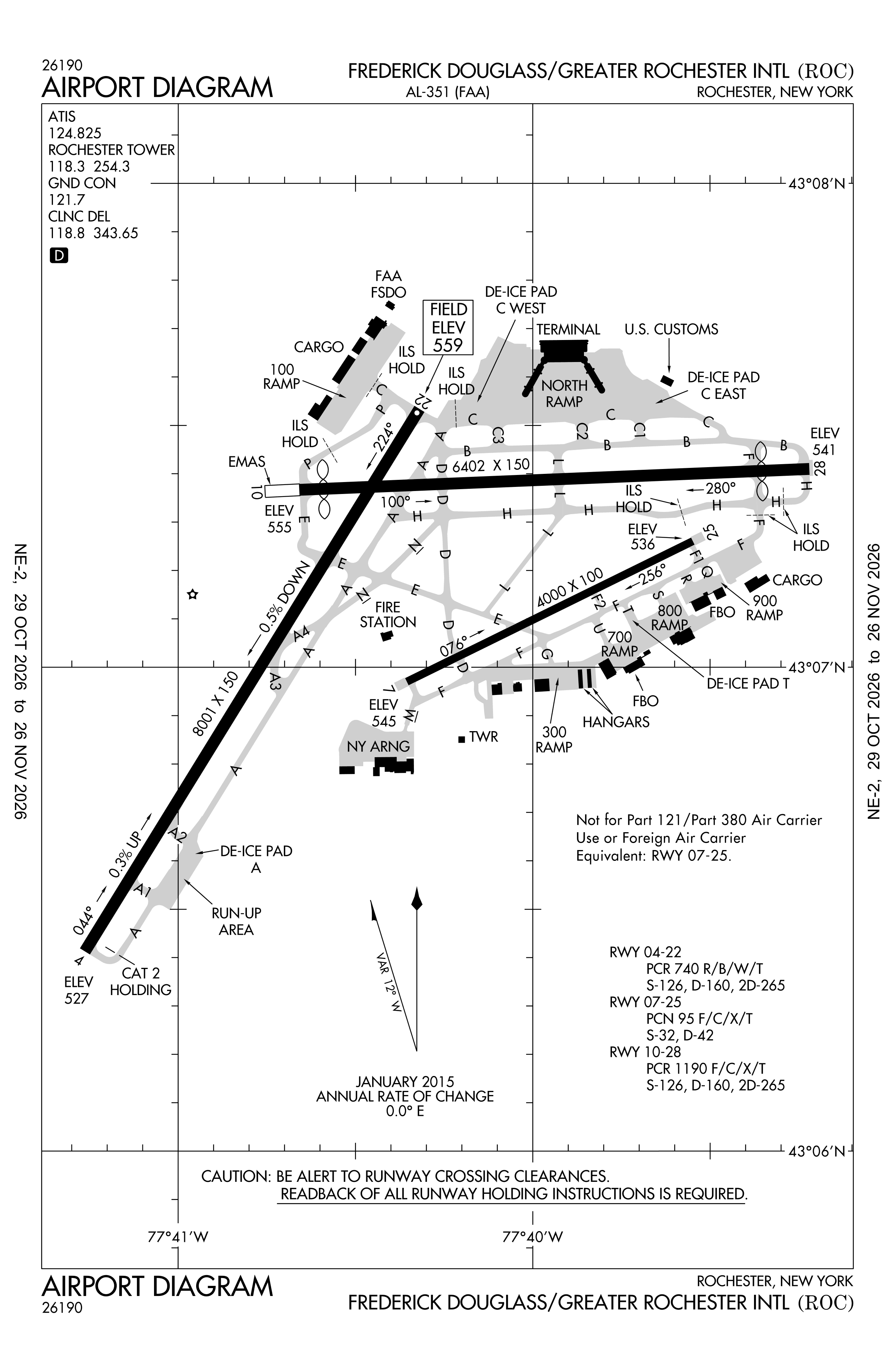
Redrawn by cwsi.net from the FAA airport diagram, cycle 2611, effective Oct 29 to Nov 26, 2026, and OpenStreetMap. Reference only, not for navigation.
FBOs and services
FBOs
- USAirports FBO
FBO details may be out of date. Call ahead to confirm services and hours.
Not listed? Send a correction.
As of Nov 3, 2026.
Related
- Interactive NOTAM search for KROC (category filters, maps, share links and a NOTAM decoder)
- Frederick Douglass Greater Rochester International Airport: codes, map and current weather
- ROC weather and runway winds (METAR and TAF in plain English)
- Flights at ROC now
- NOTAMs for other US airports
More NOTAMs in New York
Times are UTC (Z). Plain-English explanations are generated by cwsi.net from the NOTAM abbreviations and may simplify; the original NOTAM text is authoritative. NOTAMs come from the FAA NOTAM Management Service; cwsi.net refreshes its copy every 3 minutes. cwsi.net is not affiliated with the FAA: always confirm NOTAMs through official sources (a standard briefing or FAA NOTAM Search) before flight.