IAG NOTAMs
Niagara Falls International Airport, Niagara Falls, NY · KIAG
Niagara Falls International Airport in Niagara Falls, New York (IATA IAG, ICAO KIAG) has 31 current NOTAMs (Notices to Air Missions): 31 in effect now and 0 starting later. By category: obstacles (13), runways (4) and aerodromes (2). The list comes from the FAA NOTAM Management Service, refreshed by cwsi.net every few minutes; each NOTAM shows its number, category, start and end time in UTC, and a plain-English reading.
- Obstacle13
- Runway4
- Aerodrome2
- Navaid2
- Taxiway2
- Airspace1
- Apron1
- Procedures1
- Other5
In effect now (31)
TWY ALL FICON WET OBS AT 2611051216. 2611051216-2611061216
RWY 28 FICON 5/5/5 100 PCT WET OBS AT 2611051215. 2611051215-2611061215
RWY 24 FICON 5/5/5 100 PCT WET OBS AT 2611051214. 2611051214-2611061214
APRON ALL FICON WET OBS AT 2611051213. 2611051213-2611061213
RWY 10/28 WIP SURVEYING SE END 2611051213-2611052300
OBST TOWER LGT (ASR UNKNOWN) 430428.76N0790000.93W (3.5NM SW IAG) 836FT (267FT AGL) U/S 2611030932-2702032359
M0259/26 NOTAMN Q) ZOB/QFAXX/IV/NBO/A/000/999/4306N07856W005 A) KIAG B) 2610301247 C) 2611061600 E) AERODROME ARFF STATUS: RLS FOR CATEGORIES 1-7 (C-130 OR SMALLER); CLS FOR CATEGORIES 8-10 KC-135 TO C-5). ANY QUESTIONS CALL AIRFIELD MANAGEMENT AT 716-236-2175
AD AP FIXED BASE OPR CLSD DLY 0400-1200 2611020400-2703131200
AD AP NOT ATTENDED DLY 0400-1200 2611020400-2611291200
IAP NIAGARA FALLS INTL, NIAGARA FALLS, NY. TACAN RWY 28, ORIG-A... PROCEDURE NA. 2610271455-2706081455EST
OBST ELECTRICAL TOWER (ASN UNKNOWN) 430013N0785526W (6.7NM S IAG) 865FT (300FT AGL) NOT LGTD 2610252255-2701252359
OBST TOWER LGT (ASN 2022-AEA-12922-OE) 430139N0785554W (4.9NM S IAG) 752FT (164FT AGL) U/S 2610251618-2701232359
OBST TOWER LGT (ASR UNKNOWN) 430413.48N0790014.08W (3.39NM SW IAG) 794FT (223FT AGL) U/S 2610230433-2701152359
RWY 24 CLSD TO DEPARTING ACFT AT TWY D4 2610211015-2611212359
OBST TOWER LGT (ASR UNKNOWN) 430400N0790000W (3NM SW IAG) 775FT (199FT AGL) U/S 2610191227-2611242359
M0244/26 NOTAMN Q) ZOB/QMXLT/IV/NBO/A/000/999/4306N07856W005 A) KIAG B) 2610081519 C) 2611252359 E) TWY A , A1, A2, A3 AND A4 RESTRICTED TO PPR AND 914 ARW ACFT
TWY A BTN MAIN RAMP AND OPR RAMP WEST ACCESS CLSD 2610081517-2611252359
M0242/26 NOTAMN Q) ZOB/QMNLT/IV/NBO/A/000/999/4306N07856W005 A) KIAG B) 2610081453 C) 2611252359 E) MAIN RAMP SPOT 1 THROUGH SPOT 4 CLOSED MILITARY SIDE
M0241/26 NOTAMN Q) ZOB/QMNLT/IV/NBO/A/000/999/4306N07856W005 A) KIAG B) 2610081450 C) 2611252359 E) MAIN RAMP SPOT 5 NO PARKING TAXI THROUGH ONLY MILITARY SIDE
AERODROME OFFICIAL BUSINESS ONLY MILITARY SIDE ONLY 2610081442-2611252359
OBST TOWER LGT (ASR UNKNOWN) 430222.01N0785818.25W (4.24NM SSW IAG) 731.4FT (153FT AGL) U/S 2610020953-2612312359
OBST TOWER LGT (ASR UNKNOWN) 430410.2N0785959.1W (3NM SW IAG) 839FT (265FT AGL) U/S 2609260637-2612152359
OBST TOWER LGT (ASR UNKNOWN) 430351.00N0785957.00W (3.5NM SW APCH END RWY 10L) 838FT (267FT AGL) U/S 2609180812-2612092359
OBST TOWER LGT (ASR UNKNOWN) 430428.00N0790019.00W (3.4NM SW IAG) 568FT (200FT AGL) U/S 2609180811-2612092359
OBST TOWER LGT (ASR UNKNOWN) 430358.24N0790008.37W (3.5NM SW IAG) 794FT (222FT AGL) U/S 2609172224-2612082359
OBST TOWER LGT (ASR UNKNOWN) 430358.24N0790008.37W (4.3NM SW IAG) 794FT (222FT AGL) U/S 2609172223-2612082359
OBST TOWER LGT (ASN 2022-AEA-3247-OE) 431108N0785906W (5.0NM NNW IAG) 545FT (195FT AGL) U/S 2609162338-2612152359
NAV TACAN UNUSABLE 2609031111-2612012359
OBST TOWER LGT (ASR UNKNOWN) 430428.76N0790009.93W (3.4NM SW IAG) 836FT (267FT AGL) U/S 2608210239-2611172359
NAV ILS RWY 28 OM U/S 2607021132-2701262111EST
AIRSPACE UAS WI AN AREA DEFINED AS 430819N0790231W (4.6NM WNW IAG) TO 430823N0790222W (4.5NM NW IAG) TO 430822N0790158W (4.2NM NW IAG) TO 430809N0790141W (4.0NM NW IAG) TO 430812N0785913W (2.5NM NW IAG) TO 430835N0785821W (2.4NM NNW IAG) TO 430946N0785859W (3.6NM NNW IAG) TO 430936N0790017W (4.0NM NNW IAG) TO 430909N0790109W (4.2NM NW IAG) TO 430844N0790125W (4.1NM NW IAG) TO 430845N0790231W (4.8NM NW IAG) TO POINT OF ORIGIN SFC-200FT AGL 2606260000-2701152359
Airport diagram
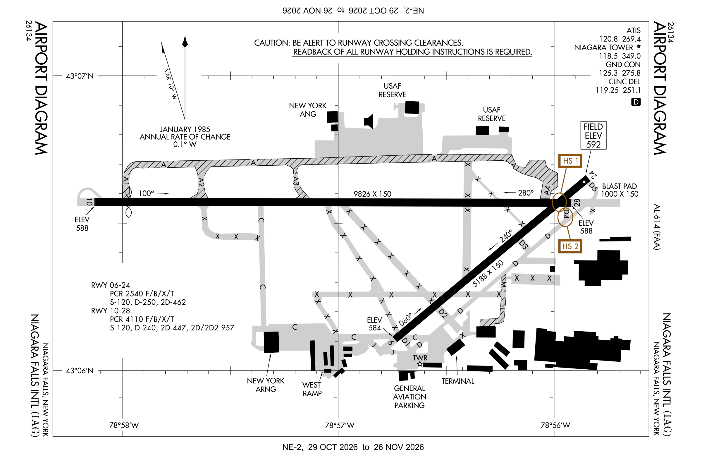
Official FAA PDF (effective Oct 29 to Nov 26)
FAA airport diagram, cycle 2611, effective Oct 29 to Nov 26, 2026. Reference only, not for navigation.
FBOs and services
FBOs
No FBOs are listed in OpenStreetMap for this airport.
Not listed? The FBO may not be in OpenStreetMap. Send a correction.
Data © OpenStreetMap contributors (ODbL), as of Nov 3, 2026.
Related
- Interactive NOTAM search for KIAG (category filters, maps, share links and a NOTAM decoder)
- Niagara Falls International Airport: codes, map and current weather
- IAG weather and runway winds (METAR and TAF in plain English)
- Flights at IAG now
- NOTAMs for other US airports
More NOTAMs in New York
Times are UTC (Z). Plain-English explanations are generated by cwsi.net from the NOTAM abbreviations and may simplify; the original NOTAM text is authoritative. NOTAMs come from the FAA NOTAM Management Service; cwsi.net refreshes its copy every 3 minutes. cwsi.net is not affiliated with the FAA: always confirm NOTAMs through official sources (a standard briefing or FAA NOTAM Search) before flight.