ISP NOTAMs
Long Island MacArthur Airport, Islip, NY · KISP
Long Island MacArthur Airport in Islip, New York (IATA ISP, ICAO KISP) has 19 current NOTAMs (Notices to Air Missions): 18 in effect now and 1 starting later. By category: taxiways (7), obstacles (4) and procedures (4). The list comes from the FAA NOTAM Management Service, refreshed by cwsi.net every few minutes; each NOTAM shows its number, category, start and end time in UTC, and a plain-English reading.
- Taxiway7
- Obstacle4
- Procedures4
- Runway3
- Aerodrome1
In effect now (18)
TWY G HOLDING BAY BTN APCH END OF RWY 06 AND WEST OF TWY W COMMISSIONED 380FT X 125FT ASPH LGTD 2611161900-PERM
TWY G HOLDING BAY COMMISSIONED BTN APCH END OF RWY 06 AND WEST OF TWY W 380FT X 125FT ASPH LGTD 2611161900-2702162100
TWY D CLSD FOR CONSTRUCTION 2611161319-2611202100
TWY D1 CLSD FOR CONSTRUCTION 2611161319-2611202100
OBST TOWER LGT (ASR 1219580) 404503.70N0731247.60W (5.8NM WSW ISP) 529.9FT (500.0FT AGL) U/S 2611141932-2703141932
AD AP WINDCONE TWY G LGT U/S 2611132325-2611292200
OBST TOWER LGT (ASR 1064778) 405034.00N0730154.00W (4.2NM NE ISP) 546.9FT (274.0FT AGL) U/S 2611131333-2612132300
OBST TOWER LGT (ASR 1276274) 404822.60N0730553.00W (0.6NM NE ISP) 191.6FT (94.8FT AGL) U/S 2611130648-2611280548
TWY A HLDG PSN SIGN FOR APCH END RWY 06 LGT U/S 2611090136-2612041200
RWY 24 3000FT DIST REMAINING SIGN LGT U/S 2611052243-2612312300
RWY 33L 1000FT DIST REMAINING SIGN AT RWY 33L RIGHT SIDE LGT U/S 2611020043-2612311200
TWY G HLDG PSN SIGN NORTH SIDE FOR APCH END RWY 06 LGT U/S 2610220015-2612240014EST
TWY G WIP CONST ADJ WED THU FRI MON TUE 1100-2030 2610141100-2611272030
SID LONG ISLAND MAC ARTHUR, NEW YORK, NY. LONG ISLAND SEVEN DEPARTURE... NOTE: COATE DEPARTURES NA EXCEPT FOR AIRCRAFT EQUIPPED WITH SUITABLE RNAV SYSTEM WITH GPS, SAX VORTAC OUT OF SERVICE. 2609241510-2705061510EST
OBST TOWER LGT (ASR 1054022) 404855.00N0731042.00W (3.7NM WNW ISP) 582.7FT (392.7FT AGL) U/S 2609021632-2612021630
STAR SARDI ONE ARRIVAL. DISREGARD NOTE: STAR LIMITED TO JET AND MULTI-ENGINE AIRCRAFT CAPABLE OF 210K OR GREATER. 2607090000-PERM
IAP LONG ISLAND MAC ARTHUR, NEW YORK, NY. ILS OR LOC RWY 24, AMDT 5... AUTOPILOT COUPLED APPROACH NA BELOW 920. 2510221323-2710221323EST
IAP LONG ISLAND MAC ARTHUR, NEW YORK, NY. RNAV (GPS) RWY 15R, AMDT 1... LNAV/VNAV DA 550/HAT 451 ALL CATS. 2509231452-2709231452EST
Starting later (1)
RWY 15L/33R CLSD 2611181200-2611202100
Airport diagram

FAA chart (PNG) Official FAA PDF (effective Oct 29 to Nov 26)
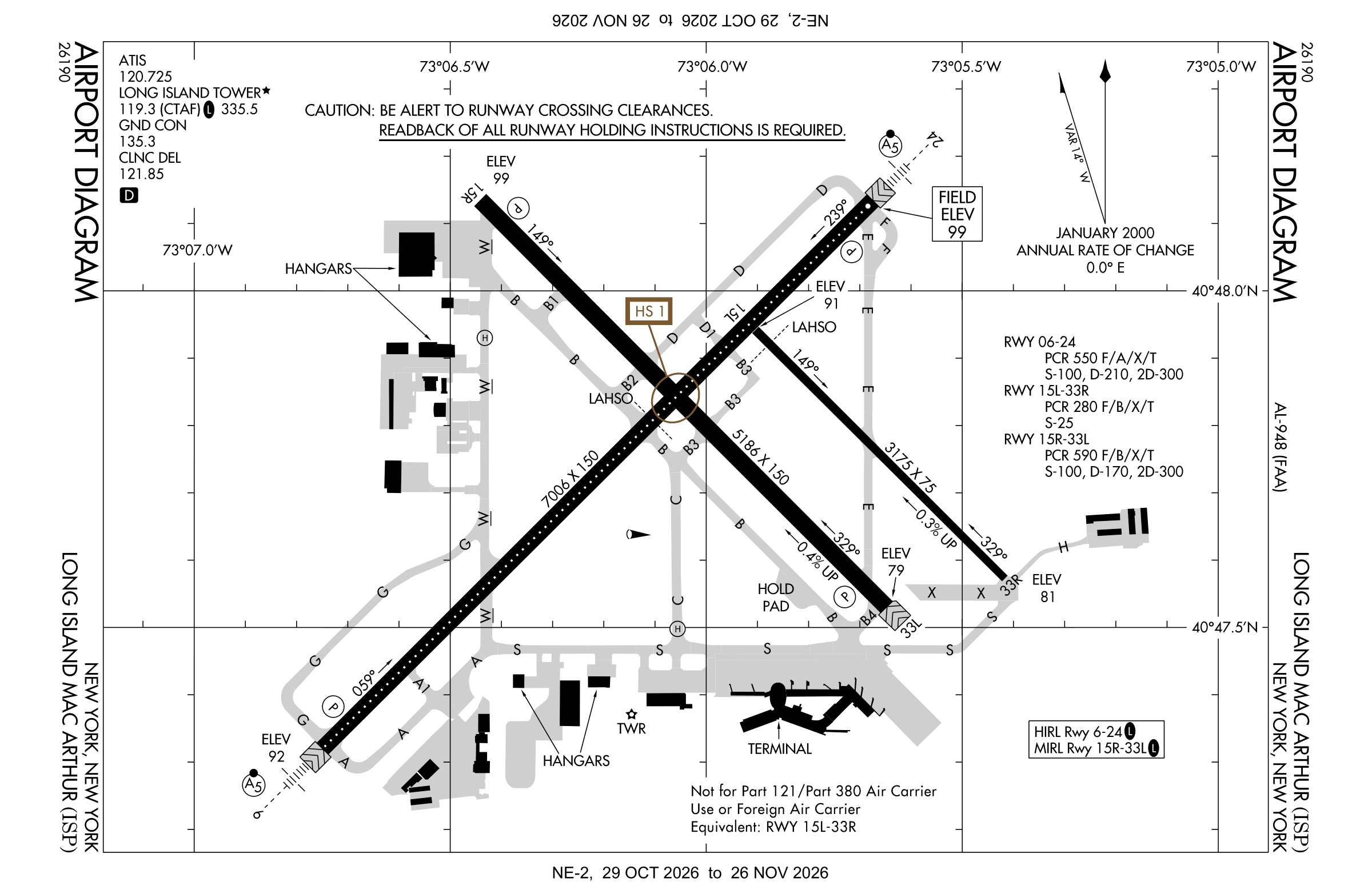
Redrawn by cwsi.net from the FAA airport diagram, cycle 2611, effective Oct 29 to Nov 26, 2026, and OpenStreetMap. Reference only, not for navigation.
FBOs and services
FBOs
- SheltairBrand website
FBO details may be out of date. Call ahead to confirm services and hours.
Not listed? Send a correction.
As of Nov 3, 2026.
Related
- Interactive NOTAM search for KISP (category filters, maps, share links and a NOTAM decoder)
- Long Island MacArthur Airport: codes, map and current weather
- ISP weather and runway winds (METAR and TAF in plain English)
- Flights at ISP now
- NOTAMs for other US airports
More NOTAMs in New York
Times are UTC (Z). Plain-English explanations are generated by cwsi.net from the NOTAM abbreviations and may simplify; the original NOTAM text is authoritative. NOTAMs come from the FAA NOTAM Management Service; cwsi.net refreshes its copy every 3 minutes. cwsi.net is not affiliated with the FAA: always confirm NOTAMs through official sources (a standard briefing or FAA NOTAM Search) before flight.