MYR NOTAMs
Myrtle Beach International Airport, Myrtle Beach, SC · KMYR
Myrtle Beach International Airport in Myrtle Beach, South Carolina (IATA MYR, ICAO KMYR) has 31 current NOTAMs (Notices to Air Missions): 30 in effect now and 1 starting later. By category: taxiways (10), runways (7) and obstacles (4). The list comes from the FAA NOTAM Management Service, refreshed by cwsi.net every few minutes; each NOTAM shows its number, category, start and end time in UTC, and a plain-English reading.
- Taxiway10
- Runway7
- Obstacle4
- Apron3
- Aerodrome2
- Procedures2
- Airspace1
- Navaid1
- Services1
In effect now (30)
TWY B3 HLDG PSN SIGN LGT U/S 2611170101-2612162200
NAV ILS RWY 36 U/S 2611161050-2703242000EST
OBST TOWER LGT (ASR 1046190) 333546.00N0790310.00W (8.1NM SW MYR) 815.0FT (799.9FT AGL) U/S 2611142000-2612142300
RWY 18/36 CLSD DLY 0600-1100 2611160600-2611181100
RWY 18/36 CLSD EXC SKED AIR CARRIERS DLY 0400-0600 2611150400-2611250600
RWY 36 PAPI U/S 2611111119-2701082000EST
IAP MYRTLE BEACH INTL, MYRTLE BEACH, SC. ILS OR LOC RWY 36, AMDT 6... PROCEDURE NA. 2611102058-2706222058EST
OBST TOWER LGT (ASR 1256247) 334217.40N0785405.40W (2.0NM NE MYR) 258.9FT (237.9FT AGL) U/S 2611080611-2611230511
RWY 36 2000FT DIST REMAINING SIGN LGT NOT STD MISSING 2611050456-2612042200
RWY 18 7000FT DIST REMAINING SIGN LGT NOT STD MISSING 2611050455-2612042200
OBST TOWER LGT (ASR 1045942) 332953.80N0790540.70W (13.9NM SW MYR) 333.0FT (307.1FT AGL) U/S 2611031323-2702011323
AIRSPACE UAS WI AN AREA DEFINED AS 0.1NM RADIUS OF 334022N0785439W (1.0NM SE MYR) SFC-75FT AGL 2611021300-2612112000
SVC PCL RWY 36 PAPI U/S 2610021243-2703292000EST
TWY B BTN 135FT SOUTH OF NORTH EDGE GA RAMP AND 1921FT SOUTH OF NORTH EDGE GA RAMP CLSD 2609281856-2701042200
TWY B CL AND EDGE MARKINGS 1474FT N OF GA RAMP NON STD 2609242008-2701042200
APRON GA RAMP N 1150FT CLSD TO ACFT WINGSPAN MORE THAN 117FT 2609242008-2701042200
APRON GA RAMP NE BTN 135FT S OF N EDGE TO 1921FT S OF N EDGE CLSD LGTD AND BARRICADED 2609241953-2701042200
TWY B CL BTN GA RAMP SOUTH EDGE AND 704FT NORTH OF SOUTH EDGE OF GA RAMP NOT STD 2609241144-2701042200
TWY B CL BTN GA RAMP NORTH EDGE AND 152FT SOUTH OF GA RAMP NORTH EDGE NOT STD 2609241144-2701042100
TWY B BTN SOUTH EDGE TWY B3 AND 135FT SOUTH OF NORTH EDGE OF GA RAMP CLSD TO ACFT WINGSPAN MORE THAN 92FT 2609241144-2701041100
TWY B2 CLSD 2609241140-2701042200
TWY B, B1, B3, B5 WIP ADJ MEN AND EQPT 2609241136-2701042200
TWY B WIP CONST ADJ GA RAMP 2609241135-2701041100
AD AP WINDCONE FOR RWY 36 U/S 2609241130-2701041100
APRON GA RAMP WIP MAINT MEN AND EQPT ADJ TWY B 2609241129-2701041100
TWY B5 WIP CONST ADJ NORTHWEST EDGE 2609241128-2701041100
OBST TOWER LGT (ASR 1044153) 333528.00N0790254.00W (8.1NM SW MYR) 1031.5FT (1011.5FT AGL) U/S 2609231330-2701211330
ODP MYRTLE BEACH INTL, MYRTLE BEACH, SC. TAKEOFF MINIMUMS AND (OBSTACLE) DEPARTURE PROCEDURES AMDT 2... ADD TAKEOFF OBSTACLE NOTE: RWY 36, TEMPORARY CRANE 2636FT FROM DER, 1179FT LEFT OF CENTERLINE, 120FT AGL/ 133FT MSL (2023-ASO-24634-OE). ALL OTHER DATA REMAINS AS PUBLISHED. 2608261207-2701221207EST
RWY 36 SEQUENCED FLG LGT U/S 2608201017-2704302000EST
AD AP BIRD ACT MIGRATORY WATERFOWL 2608041450-2611181300
Starting later (1)
RWY 18/36 CLSD DLY 0600-1000 2611190600-2611251000
Airport diagram

FAA chart (PNG) Official FAA PDF (effective Oct 29 to Nov 26)
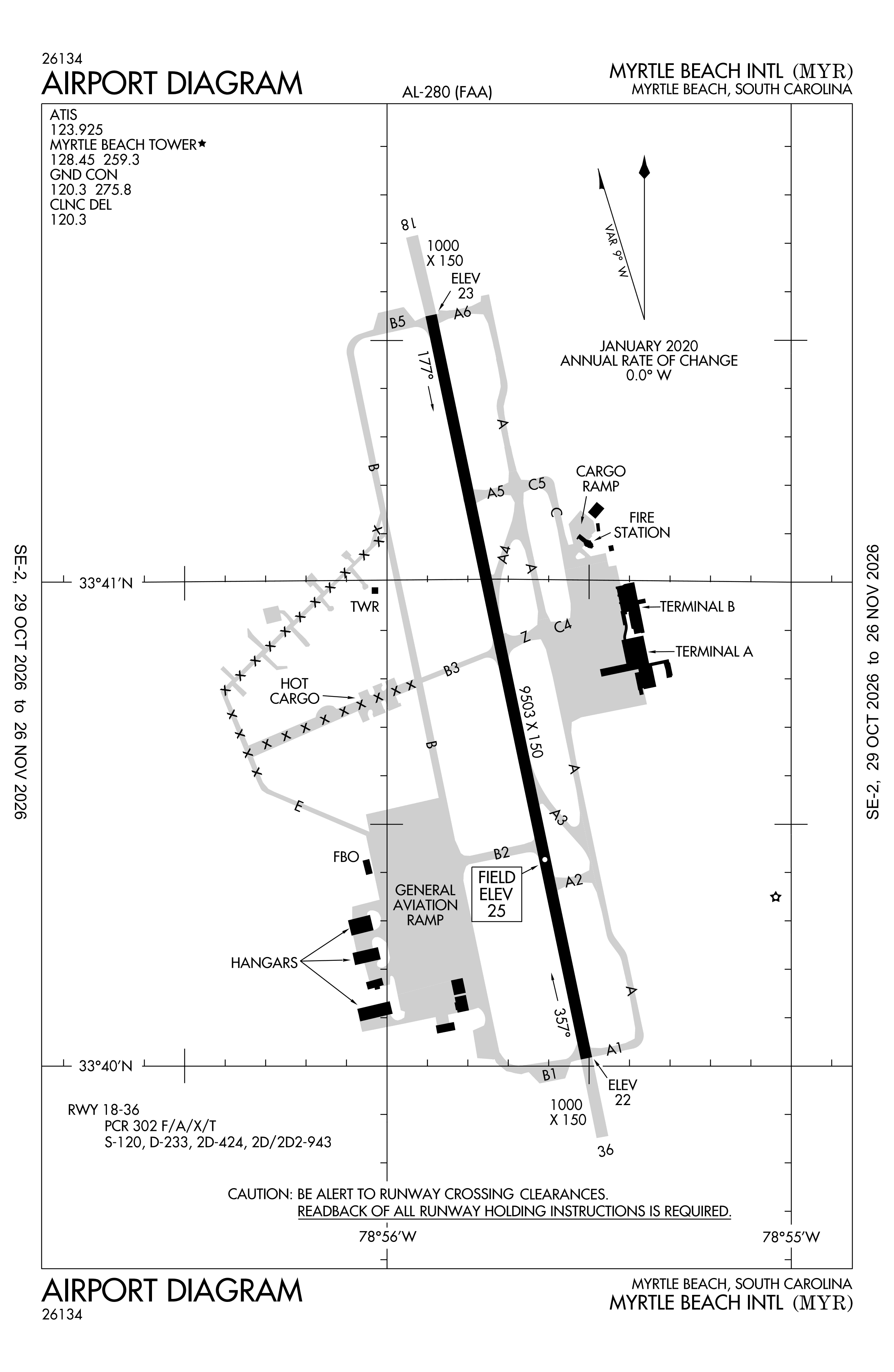
Redrawn by cwsi.net from the FAA airport diagram, cycle 2611, effective Oct 29 to Nov 26, 2026, and OpenStreetMap. Reference only, not for navigation.
FBOs and services
Related
- Interactive NOTAM search for KMYR (category filters, maps, share links and a NOTAM decoder)
- Myrtle Beach International Airport: codes, map and current weather
- MYR weather and runway winds (METAR and TAF in plain English)
- Flights at MYR now
- NOTAMs for other US airports
More NOTAMs in South Carolina
Times are UTC (Z). Plain-English explanations are generated by cwsi.net from the NOTAM abbreviations and may simplify; the original NOTAM text is authoritative. NOTAMs come from the FAA NOTAM Management Service; cwsi.net refreshes its copy every 3 minutes. cwsi.net is not affiliated with the FAA: always confirm NOTAMs through official sources (a standard briefing or FAA NOTAM Search) before flight.