GSP NOTAMs
Greenville-Spartanburg International Airport, Greenville, SC · KGSP
Greenville-Spartanburg International Airport in Greenville, South Carolina (IATA GSP, ICAO KGSP) has 18 current NOTAMs (Notices to Air Missions): 12 in effect now and 6 starting later. By category: runways (7), navaids (5) and procedures (3). The list comes from the FAA NOTAM Management Service, refreshed by cwsi.net every few minutes; each NOTAM shows its number, category, start and end time in UTC, and a plain-English reading.
- Runway7
- Navaid5
- Procedures3
- Obstacle2
- Apron1
In effect now (12)
RWY 04/22 CLSD DLY 0530-1015 2611160530-2611191015
NAV ILS RWY 04 U/S 2611150134-2611172359
IAP GREENVILLE SPARTANBURG INTL, GREER, SC. ILS RWY 4 (CAT II-III), AMDT 25 ... PROCEDURE NA. 2611131743-2612251030EST
IAP GREENVILLE SPARTANBURG INTL, GREER, SC. ILS OR LOC RWY 22, AMDT 6... ILS OR LOC RWY 4, AMDT 25... ILS RWY 4 (SA CAT I), AMDT 25... ILS RWY 4 (CAT II AND III), AMDT 25... PROCEDURE NA EXCEPT FOR ACFT EQUIPPED WITH SUITABLE RNAV SYSTEM WITH GPS, SPA VORTAC OUT OF SERVICE. 2611042212-2706162212EST
RWY 22 LEAD OFF LGT AT TWY F AND TWY D U/S 2610271450-2612251030
RWY 04 LEAD OFF LGT AT TWY E AND TWY G U/S 2610271449-2612251030
RWY 04 RTZL U/S 2610271448-2612251030
RWY 04/22 RCLL U/S 2610271448-2612251030
APRON GA RAMP WIP CONST ADJ NE EDGE LGTD AND FENCED 2610271446-2611302200
OBST TOWER LGT (ASR 1001611) 345432.80N0821043.50W (2.1NM ENE GSP) 1108.6FT (139.8FT AGL) U/S 2609201513-2612191613
OBST TOWER LGT (ASR 1014479) 344808.00N0820760.00W (6.9NM SE GSP) 1013.8FT (210.0FT AGL) U/S 2609060744-2612050844
ODP GREENVILLE SPARTANBURG INTL, GREER, SC. TAKEOFF MINIMUMS AND (OBSTACLE) DEPARTURE PROCEDURES AMDT 1A... TAKEOFF OBSTACLE NOTE: RWY 22, TREE 1850 FT FROM DER, 970 FT LEFT OF CENTERLINE, 992 FT MSL. TREE 2052 FT FROM DER, 1006 FT LEFT OF CENTERLINE, 993 FT MSL.. ALL OTHER DATA REMAINS AS PUBLISHED. 2509022004-2709022004EST
Starting later (6)
RWY 04/22 CLSD DLY 0630-1015 2611220630-2612021015
RWY 04/22 CLSD 2611200630-2611201015
NAV ILS RWY 04 GP U/S 2611171200-2611172200
NAV ILS RWY 22 GP U/S 2611181100-2611182200
NAV ILS RWY 04 LOC/DME U/S 2611181100-2611182200
NAV ILS RWY 22 U/S 2611171200-2611172200
Airport diagram

FAA chart (PNG) Official FAA PDF (effective Oct 29 to Nov 26)
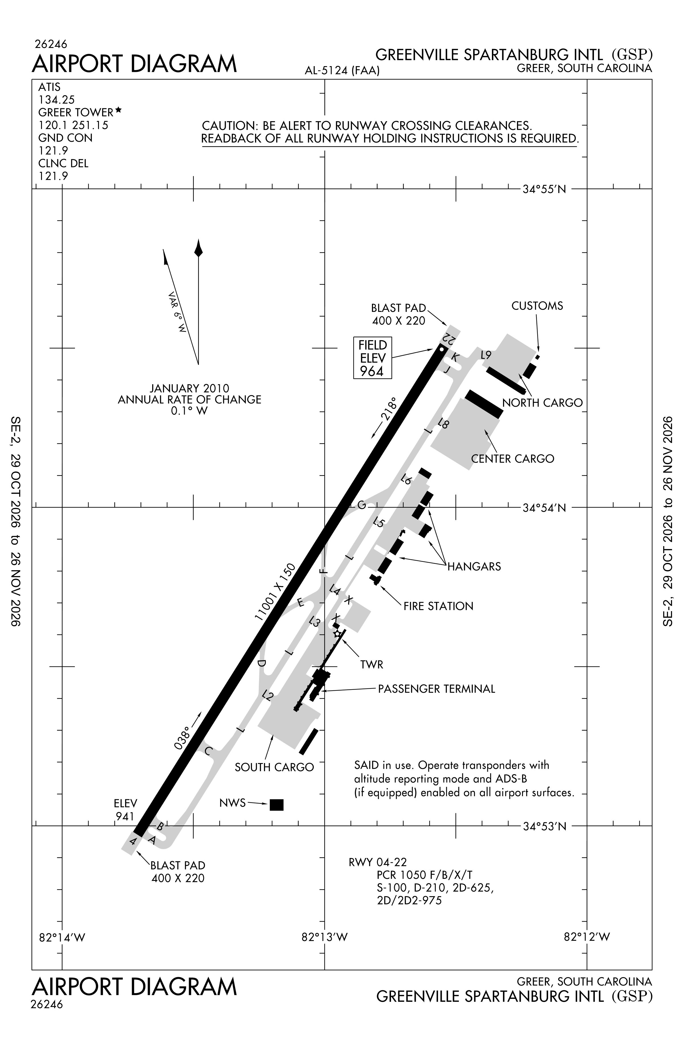
Redrawn by cwsi.net from the FAA airport diagram, cycle 2611, effective Oct 29 to Nov 26, 2026, and OpenStreetMap. Reference only, not for navigation.
FBOs and services
Related
- Interactive NOTAM search for KGSP (category filters, maps, share links and a NOTAM decoder)
- Greenville-Spartanburg International Airport: codes, map and current weather
- GSP weather and runway winds (METAR and TAF in plain English)
- Flights at GSP now
- NOTAMs for other US airports
More NOTAMs in South Carolina
Times are UTC (Z). Plain-English explanations are generated by cwsi.net from the NOTAM abbreviations and may simplify; the original NOTAM text is authoritative. NOTAMs come from the FAA NOTAM Management Service; cwsi.net refreshes its copy every 3 minutes. cwsi.net is not affiliated with the FAA: always confirm NOTAMs through official sources (a standard briefing or FAA NOTAM Search) before flight.