LIT NOTAMs
Bill and Hillary Clinton National Airport, Little Rock, AR · KLIT
Bill and Hillary Clinton National Airport in Little Rock, Arkansas (IATA LIT, ICAO KLIT) has 31 current NOTAMs (Notices to Air Missions): 24 in effect now and 7 starting later. By category: obstacles (12), runways (10) and taxiways (4). The list comes from the FAA NOTAM Management Service, refreshed by cwsi.net every few minutes; each NOTAM shows its number, category, start and end time in UTC, and a plain-English reading.
- Obstacle12
- Runway10
- Taxiway4
- Navaid3
- Procedures1
- Services1
In effect now (24)
OBST TOWER LGT (ASR 1220387) 344125.50N0920528.70W (7.0NM ESE LIT) 503.6FT (259.8FT AGL) U/S 2611141841-2611291741
NAV TACAN AZM U/S 2610261138-2703312000EST
OBST TOWER LGT (ASR 1040546) 344329.30N0921857.50W (4.5NM W LIT) 590.2FT (230.0FT AGL) U/S 2609301830-2611302359
TWY M BTN RWY 04L/22R AND TWY F CLSD 2609211200-PERM
TWY J BTN RWY 04L/22R AND TWY F CLSD 2609211200-PERM
TWY F BTN TWY H AND TWY J, TWY J BTN TERMINAL RAMP AND TWY F CLSD 2609211200-2612312300
TWY F6, F5, C1, C2, TWY F BTN TWY F6 AND TWY F4, TWY C BTN DASSAULT FALCON JET SERVICE CENTER RAMP C ACCESS AND TWY C1, TWY F BTN TWY J AND APCH END RWY 22R, TWY M BTN TWY F AND CARGO RAMP CLSD 2609211200-2705072200
RWY 04L/22R CLSD EXC XNG 2609211200-2705072200
RWY 04L PAPI U/S 2609211200-2705072200
RWY 22R PAPI U/S 2609211200-2705072200
RWY 04L ALS U/S 2609211200-2705072200
RWY 22R ALS U/S 2609211200-2705072200
RWY 22R RVRM U/S 2609211200-2705072300
RWY 04L RVRM U/S 2609211200-2705072300
RWY 04L RVRT U/S 2609211200-2705072300
RWY 22R RVRT U/S 2609211200-2705072300
NAV ILS RWY 04L U/S 2609211200-2705072300
NAV ILS RWY 22R U/S 2609211200-2705072300
OBST CRANE (ASN UNKNOWN) 344346N0921327W (.37NM NW LIT) UNKNOWN (150FT AGL) FLAGGED AND LGTD 2602021820-2708021700
OBST CRANE (ASN UNKNOWN) 344347N0921326W (.37NM NW LIT) UNKNOWN (150FT AGL) FLAGGED AND LGTD 2602021818-2708021700
OBST CRANE (ASN UNKNOWN) 344344N0921315W (.37NM NW LIT) UNKNOWN (150FT AGL) FLAGGED AND LGTD 2602021817-2708021700
OBST CRANE (ASN UNKNOWN) 344344N0921315W (.37NM NW LIT) UNKNOWN (150FT AGL) FLAGGED AND LGTD 2602021815-2708021700
IAP BILL AND HILLARY CLINTON NTL/ADAMS FLD, LITTLE ROCK, AR. ILS OR LOC RWY 4R, AMDT 3... AUTOPILOT COUPLED APPROACH NA BELOW 460FT MSL. 2511271342-2711271342EST
RWY 04R RTZL DECOMMISSIONED 2311252017-PERM
Starting later (7)
OBST CRANE (ASN 2025-ASW-7549-NRA) 344342N0921309W (0.3NM ESE LIT) 407FT (150FT AGL) FLAGGED AND LGTD 2611171300-2612042300
SVC TAR/SSR U/S 2611171300-2611172200
OBST CRANE (ASN 2025-ASW-4272-OE) 344346N0921210W (1.1NM E LIT) 361FT (91FT AGL) FLAGGED 2611211400-2611212200
OBST CRANE (ASN 2025-ASW-4272-OE) 344346N0921210W (1.1NM E LIT) 361FT (91FT AGL) FLAGGED 2611201400-2611202200
OBST CRANE (ASN 2025-ASW-4272-OE) 344346N0921210W (1.1NM E LIT) 361FT (91FT AGL) FLAGGED 2611191400-2611192200
OBST CRANE (ASN 2025-ASW-4272-OE) 344346N0921210W (1.1NM E LIT) 361FT (91FT AGL) FLAGGED 2611181400-2611182200
OBST CRANE (ASN 2025-ASW-4272-OE) 344346N0921210W (1.1NM E LIT) 361FT (91FT AGL) FLAGGED 2611171400-2611172200
Airport diagram

FAA chart (PNG) Official FAA PDF (effective Oct 29 to Nov 26)
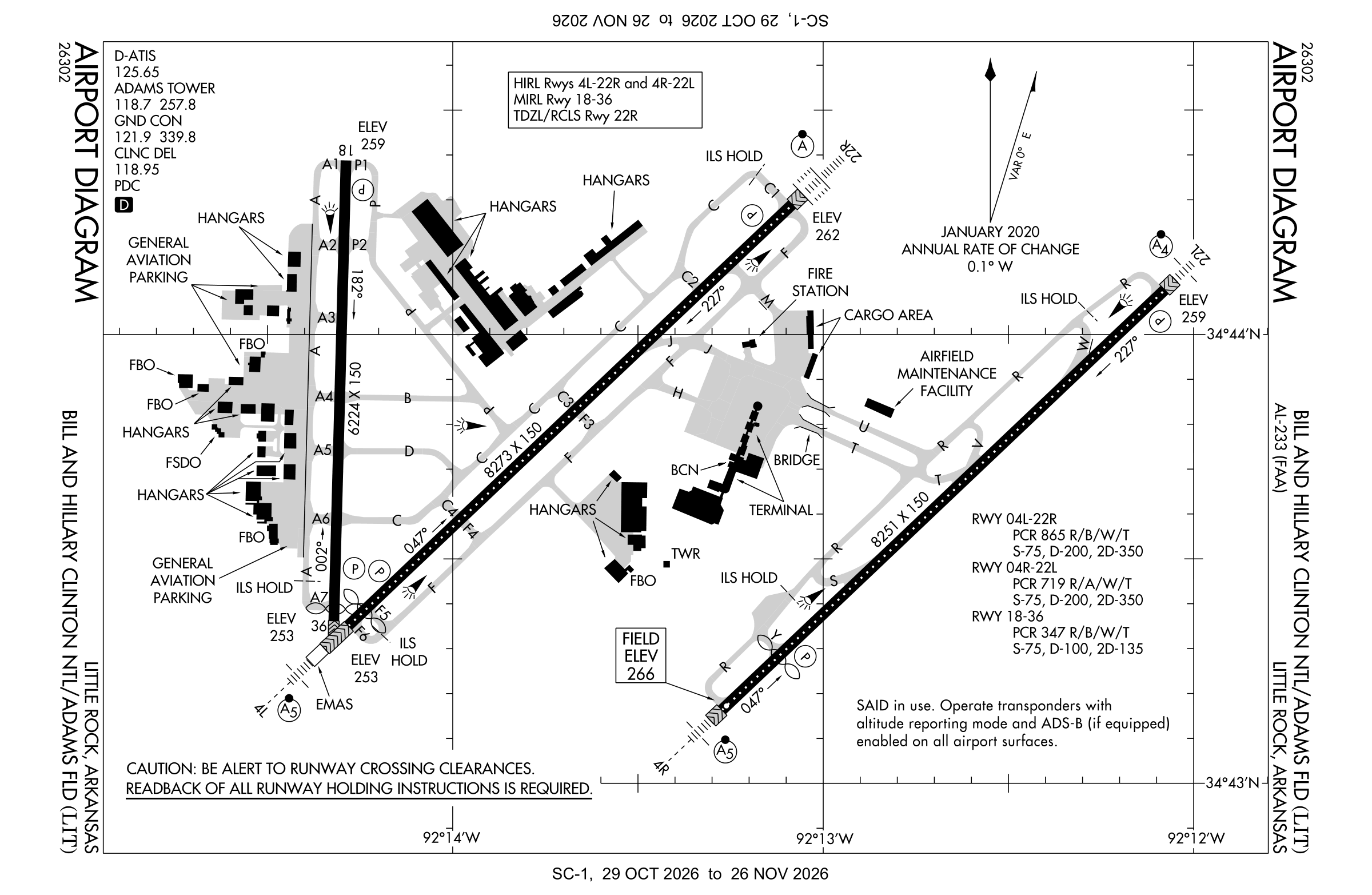
Redrawn by cwsi.net from the FAA airport diagram, cycle 2611, effective Oct 29 to Nov 26, 2026, and OpenStreetMap. Reference only, not for navigation.
FBOs and services
FBOs
 Atlantic Aviation Little Rock2400 David Grundfest Jr. Drive, Building 500A, Little Rock, AR+1 501-376-7777Hours: Mon-Sun: 0500-2200 On-call services with prior arrangementsAtlantic page
 Signature Little Rock2401 Crisp Drive, Little Rock, AR 72202+1 501-374-6582Hours: 24 hours a day/7 days a weekARINC 130.40Signature page
- Lynx FBO
FBO details may be out of date. Call ahead to confirm services and hours.
Not listed? Send a correction.
As of Nov 3, 2026.
Related
- Interactive NOTAM search for KLIT (category filters, maps, share links and a NOTAM decoder)
- Bill and Hillary Clinton National Airport: codes, map and current weather
- LIT weather and runway winds (METAR and TAF in plain English)
- Flights at LIT now
- NOTAMs for other US airports
More NOTAMs in Arkansas
Times are UTC (Z). Plain-English explanations are generated by cwsi.net from the NOTAM abbreviations and may simplify; the original NOTAM text is authoritative. NOTAMs come from the FAA NOTAM Management Service; cwsi.net refreshes its copy every 3 minutes. cwsi.net is not affiliated with the FAA: always confirm NOTAMs through official sources (a standard briefing or FAA NOTAM Search) before flight.