XNA NOTAMs
Northwest Arkansas National Airport, Fayetteville, AR · KXNA
Northwest Arkansas National Airport in Fayetteville, Arkansas (IATA XNA, ICAO KXNA) has 12 current NOTAMs (Notices to Air Missions): 12 in effect now and 0 starting later. By category: aprons (3), procedures (3) and runways (3). The list comes from the FAA NOTAM Management Service, refreshed by cwsi.net every few minutes; each NOTAM shows its number, category, start and end time in UTC, and a plain-English reading.
- Apron3
- Procedures3
- Runway3
- Aerodrome1
- Obstacle1
- Taxiway1
In effect now (12)
APRON TERMINAL RAMP WIP CONST ADJ TO TWY GOLF LGTD AND BARRICADED 2611162039-2703312200
RWY 16R/34L CLSD EXC TAX 2611161908-2612311700
IAP NORTHWEST ARKANSAS NTL, FAYETTEVILLE/SPRINGDALE/ROGERS, AR. RNAV (GPS) RWY 34R, ORIG-A... LPV DA 1535/HAT 262 ALL CATS. LNAV/VNAV DA 1629/HAT 356 ALL CATS. VIS RVR 3000 ALL CATS. LNAV MDA 1720/HAT 447 ALL CATS. VIS CAT C/D/E RVR 4500. FOR INOP ALS, INCREASE LPV ALL CATS VISIBILITY TO RVR 4500, LNAV/VNAV ALL CATS VISIBILITY TO RVR 5500 AND LNAV CAT C/D/E VISIBILITYT TO 1 3/8 SM. TEMPORARY CRANES, UP TO 1418 MSL, BEGINNING 1554FT NORTH OF RWY 34R (2026-ASW-1405 THRU 1416-NRA). 2611131804-2706251804EST
IAP NORTHWEST ARKANSAS NTL, FAYETTEVILLE/SPRINGDALE/ROGERS, AR. ILS OR LOC RWY 34R, ORIG-A... S-ILS 34R* DA 1535/HAT 262 ALL CATS. S-LOC 34R MDA 1700/HAT 427 ALL CATS. VIS CAT C/D/E RVR 4000. VDP NA. FOR INOP ALS, INCREASE S-ILS 34R ALL CATS VISIBILITY TO RVR 4500 AND S-LOC 34R CATS C/D/E VISIBILITY TO 1 3/8 SM. TEMPORARY CRANES, UP TO 1418 MSL, BEGINNING 1554FT NORTH OF RWY 34R (2026-ASW-1405 THRU 1416-NRA). 2611131804-2706251804EST
ODP NORTHWEST ARKANSAS NTL, FAYETTEVILLE/SPRINGDALE/ROGERS, AR. TAKEOFF MINIMUMS AND (OBSTACLE) DEPARTURE PROCEDURES AMDT 5... TAKEOFF OBSTACLE NOTES: RWY 16L, TEMPORARY SYSTEM EQUIPMENT, 2064FT FROM DER, 1011FT LEFT OF CENTERLINE, 85 AGL/1335 MSL (2022-ASW-175-NRA). ALL OTHER DATA REMAINS AS PUBLISHED. 2611121932-2706241932EST
APRON TERMINAL RAMP WIP CONST ADJ LGTD AND BARRICADED 2610301929-2612312200
TWY E BTN TWY B AND TWY H CLSD 2610301928-2612312200
APRON TERMINAL RAMP WIP IRREGULAR SFC STEEL PLATE 2607311509-2612312300
AD AP WINDCONE PRI U/S 2604141517-2611301400
OBST SILO (ASN 2025-ASW-8100-NRA) 361657N0941751W (0.5NM E XNA) 1350FT (80FT AGL) LGTD 2603181511-2708062200
RWY 16R PAPI U/S 2512101723-2612311300
RWY 34L PAPI U/S 2512101637-2612311300
Airport diagram

FAA chart (PNG) Official FAA PDF (effective Oct 29 to Nov 26)
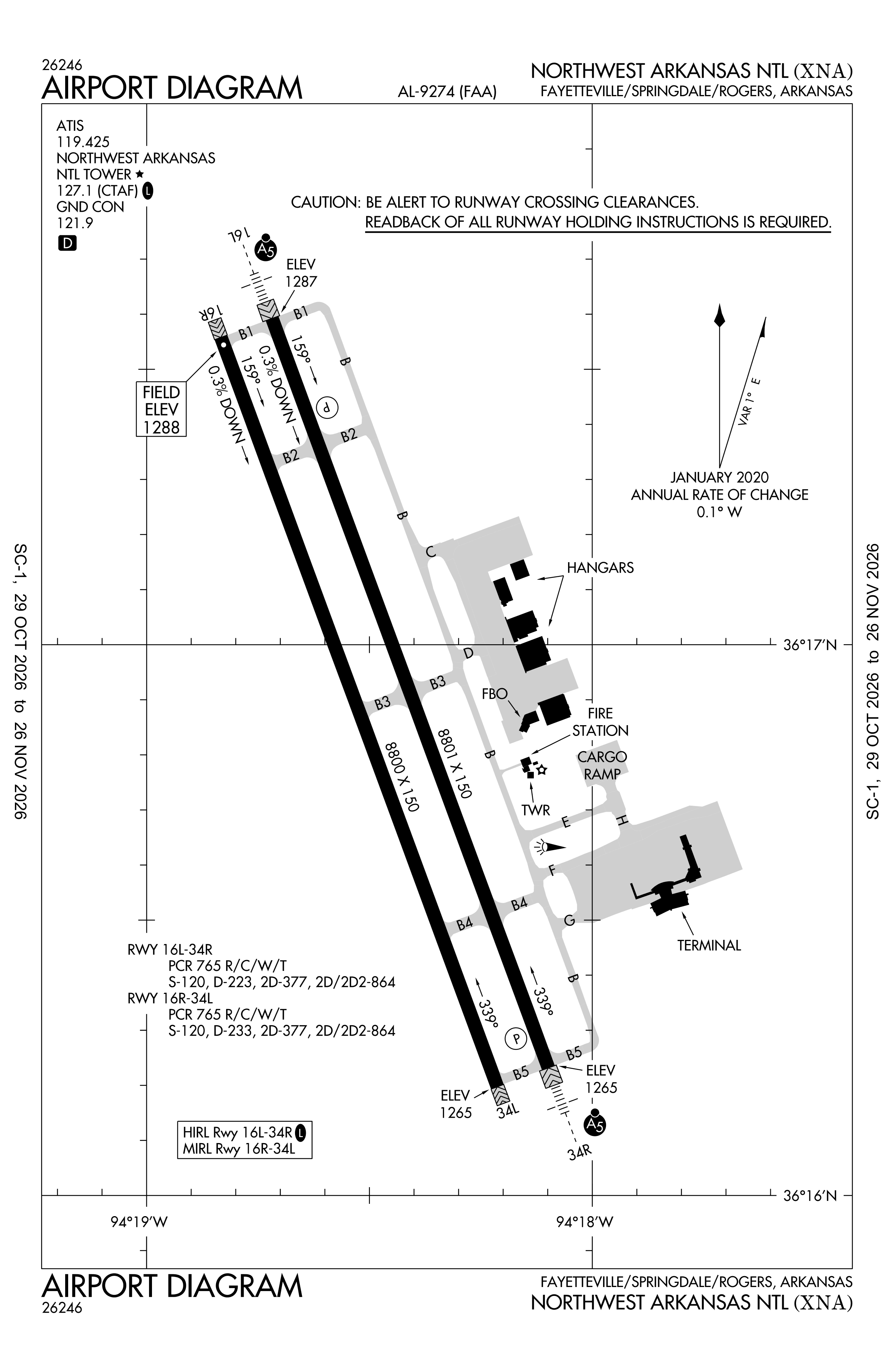
Redrawn by cwsi.net from the FAA airport diagram, cycle 2611, effective Oct 29 to Nov 26, 2026, and OpenStreetMap. Reference only, not for navigation.
FBOs and services
FBOs
- Regional Jet Center
FBO details may be out of date. Call ahead to confirm services and hours.
Not listed? Send a correction.
As of Nov 3, 2026.
Related
- Interactive NOTAM search for KXNA (category filters, maps, share links and a NOTAM decoder)
- Northwest Arkansas National Airport: codes, map and current weather
- XNA weather and runway winds (METAR and TAF in plain English)
- Flights at XNA now
- NOTAMs for other US airports
More NOTAMs in Arkansas
Times are UTC (Z). Plain-English explanations are generated by cwsi.net from the NOTAM abbreviations and may simplify; the original NOTAM text is authoritative. NOTAMs come from the FAA NOTAM Management Service; cwsi.net refreshes its copy every 3 minutes. cwsi.net is not affiliated with the FAA: always confirm NOTAMs through official sources (a standard briefing or FAA NOTAM Search) before flight.