VLD NOTAMs
Valdosta Regional Airport, Valdosta, GA · KVLD
Valdosta Regional Airport in Valdosta, Georgia (IATA VLD, ICAO KVLD) has 28 current NOTAMs (Notices to Air Missions): 28 in effect now and 0 starting later. By category: procedures (11), obstacles (10) and runways (6). The list comes from the FAA NOTAM Management Service, refreshed by cwsi.net every few minutes; each NOTAM shows its number, category, start and end time in UTC, and a plain-English reading.
- Procedures11
- Obstacle10
- Runway6
- Services1
In effect now (28)
OBST TOWER LGT (ASR 1253538) 305148.60N0832340.10W (7.7NM NW VLD) 444.9FT (254.9FT AGL) U/S 2611012330-2703012330
OBST TOWER LGT (ASR 1027340) 302854.70N0832654.90W (20.3NM SSW VLD) 532.8FT (404.9FT AGL) U/S 2610301634-2701222359
OBST TOWER LGT (ASR 1225567) 303457.70N0832054.10W (12.6NM SSW VLD) 388.8FT (260.8FT AGL) U/S 2610281059-2701260400
OBST TOWER LGT (ASR 1028199) 302814.20N0832341.10W (19.8NM SSW VLD) 516.1FT (324.1FT AGL) U/S 2610261048-2611292359
OBST TOWER LGT (ASR 1018689) 304116.20N0831359.90W (6.0NM SSE VLD) 479.7FT (346.8FT AGL) U/S 2610201241-2701181341
IAP VALDOSTA RGNL, VALDOSTA, GA. VOR RWY 36, AMDT 2... ASMUC FIX MINIMUMS: S-36 MDA 660/HAT 460 ALL CATS, VIS ALL CATS 1. CIRCLING CAT A/B MDA 720/HAA 517. VDP NA. CHANGE NOTE TO READ: FOR INOP ALS, INCREASE S-36 CATS A/B VISIBILITY TO 1 SM AND CATS C/D VISIBILITY TO 1 5/8 SM; ASMUC FIX MINIMUMS: INOP TABLE DOES NOT APPLY TO S-36 CATS A/B, INCREASE S-36 CATS C/D VISIBILITY TO 1 3/8 SM. TEMPORARY CRANE 349 MSL 5156FT N OF RWY 36 (2023-ASO-12123-NRA). TEMPORARY CRANE 359 MSL 1.4NM NW OF VLD AIRPORT (2026-ASO-8315-OE). 2610131925-2612181925EST
IAP VALDOSTA RGNL, VALDOSTA, GA. ILS OR LOC RWY 36, AMDT 8... RNAV (GPS) RWY 36, AMDT 2... RNAV (GPS) RWY 4, AMDT 2... CIRCLING CAT A/B MDA 720/HAA 517. TEMPORARY CRANE 359 MSL 1.4NM NW OF VLD AIRPORT (2026-ASO-8315-OE). TEMPORARY CRANE 349 MSL 1681FT NE OF VLD AIRPORT (2023-ASO-12123-NRA). 2610131925-2612181925EST
OBST TOWER LGT (ASN 2025-ASO-7122-OE) 304417N0832301W (6.2NM WSW VLD) 456FT (260FT AGL) U/S 2610101224-2611092300
SVC PCL RWY 36 ALS U/S 2610091117-2704302000EST
IAP VALDOSTA RGNL, VALDOSTA, GA. RNAV (GPS) RWY 18, AMDT 3... LNAV/VNAV DA 565/HAT 366 ALL CATS, VIS ALL CATS 1. TEMPORARY CRANE 349 MSL 2505FT SE OF RWY 18 (2023-ASO-12123-NRA). 2610071613-2705192355EST
OBST TOWER LGT (ASR 1020312) 304905.10N0831926.80W (3.3NM NW VLD) 701.1FT (498.0FT AGL) U/S 2609020715-2612010815
OBST TOWER LGT (ASR 1056418) 305808.00N0831455.00W (11.3NM NE VLD) 373.0FT (199.1FT AGL) U/S 2608251247-2611231300
OBST TOWER LGT (ASR 1225566) 303125.50N0832211.60W (16.3NM SSW VLD) 418.0FT (274.9FT AGL) U/S 2608220441-2611200541
OBST TOWER LGT (ASR 1238918) 305229.00N0831506.00W (5.8NM NNE VLD) 503.0FT (306.1FT AGL) U/S 2607031821-2701282359
RWY 36 TDZ MARKINGS AT RWY CENTERLINE OBSC 2603251838-2612312200
RWY 18 TDZ MARKINGS AT RWY CENTERLINE OBSC 2603251836-2612312200
RWY 36 LEAD ON CL MARKINGS OBSC 2603251824-2612312200
RWY 18 LEAD ON CL MARKINGS OBSC 2603251821-2612312200
IAP VALDOSTA RGNL, VALDOSTA, GA. RNAV (GPS) RWY 4, AMDT 2... STRAIGHT-IN RWY 4 NA AT NIGHT, CIRCLING RWY 4, 22 NA AT NIGHT. RWY 4 HELICOPTER VISIBILITY REDUCTION BELOW 1 SM NOT AUTHORIZED. VDP VA. 2602091738-2809211738EST
IAP VALDOSTA RGNL, VALDOSTA, GA. ILS OR LOC RWY 36, AMDT 8... RNAV (GPS) RWY 18, AMDT 3... RNAV (GPS) RWY 36, AMDT 2... VOR RWY 18, AMDT 1C... CIRCLING RWY 4, 22 NA AT NIGHT. 2602091650-2809211650EST
IAP VALDOSTA RGNL, VALDOSTA, GA. RNAV (GPS) RWY 36, AMDT 2... LPV DA 492/HAT 291, LNAV/VNAV DA 520/HAT 319, LNAV MDA 620/HAT 420 ALL CATS. CIRCLING CAT A MDA 660/HAA 457. VDP 1.2 NM TO RW36. 2601261317-2801261317EST
RWY 18/36 SAFETY AREA NOT STD EDGE 2512121810-2612312200
RWY 04/22 SAFETY AREA NOT STD SW END 2512121808-2612312200
IAP VALDOSTA RGNL, VALDOSTA, GA. ILS OR LOC RWY 36, AMDT 8... CIRCLING CAT A MDA 660/HAA 457. 2508041843-2701181843EST
IAP VALDOSTA RGNL, VALDOSTA, GA. ILS OR LOC RWY 36, AMDT 8... S-ILS 36 DA 491/HAT 291. 2508011247-2708131247EST
IAP VALDOSTA RGNL, VALDOSTA, GA. VOR RWY 18, AMDT 1C... S-18 MDA 900/HAT 701 ALL CATS, VIS CAT C 2. CIRCLING CAT A/B MDA 900/HAA 697. VDP AT OTK 2.7 DME; DISTANCE VDP TO THLD 2.1NM. 2501180109-2701180109EST
IAP VALDOSTA RGNL, VALDOSTA, GA. RNAV (GPS) RWY 4, AMDT 2... LNAV MDA 640/HAT 438 ALL CATS. CIRCLING CAT A MDA 660/HAA 457. 2501180109-2701180109EST
IAP VALDOSTA RGNL, VALDOSTA, GA. RNAV (GPS) RWY 18, AMDT 3... LPV DA NA ALL CATS. LNAV/VNAV DA NA ALL CATS. 2501180109-2701180109EST
Airport diagram
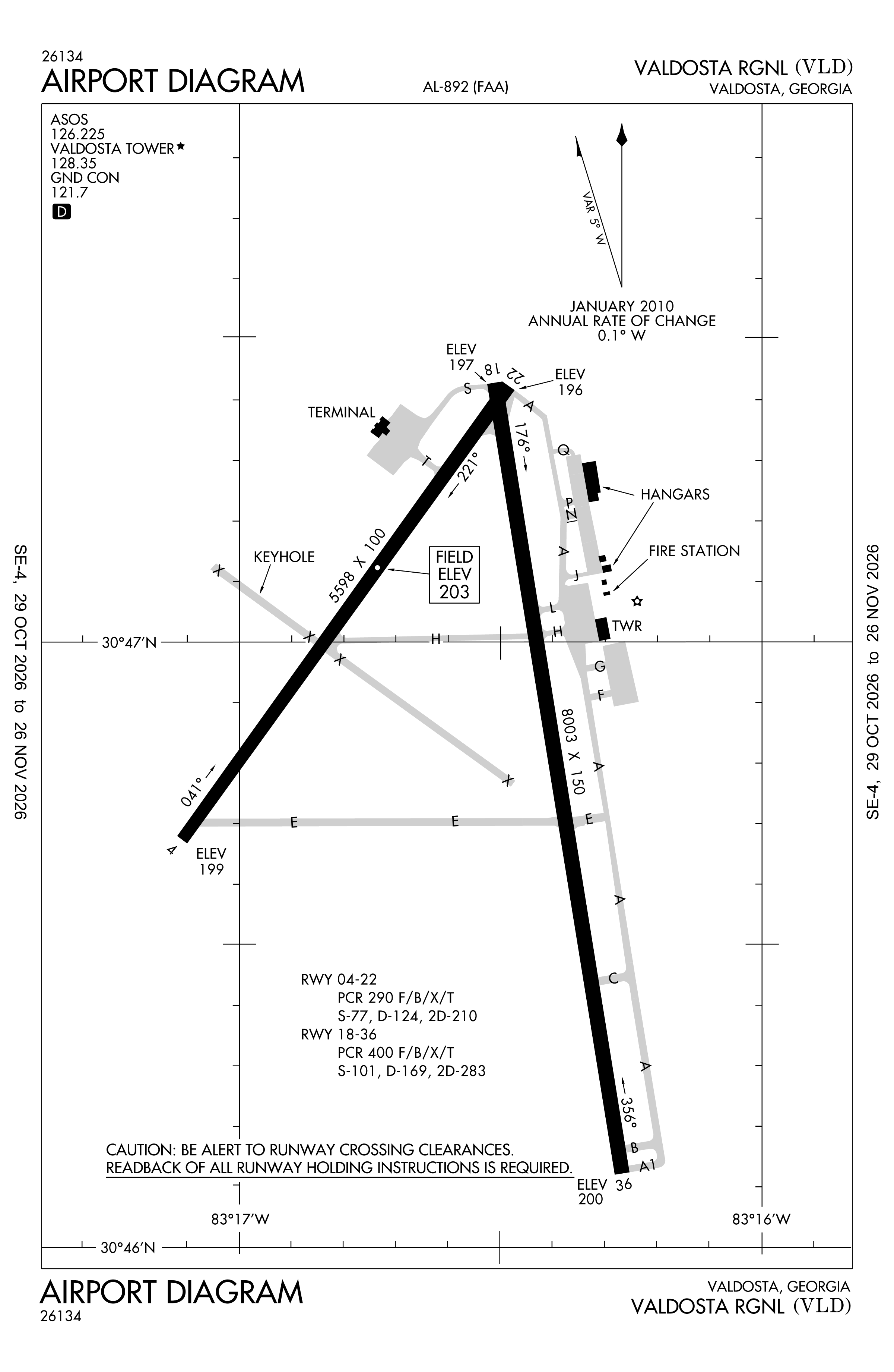
Official FAA PDF (effective Oct 29 to Nov 26)
FAA airport diagram, cycle 2611, effective Oct 29 to Nov 26, 2026. Reference only, not for navigation.
FBOs and services
FBOs
No FBOs are listed in OpenStreetMap for this airport.
Not listed? The FBO may not be in OpenStreetMap. Send a correction.
Data © OpenStreetMap contributors (ODbL), as of Nov 3, 2026.
Related
- Interactive NOTAM search for KVLD (category filters, maps, share links and a NOTAM decoder)
- Valdosta Regional Airport: codes, map and current weather
- VLD weather and runway winds (METAR and TAF in plain English)
- Flights at VLD now
- NOTAMs for other US airports
More NOTAMs in Georgia
Times are UTC (Z). Plain-English explanations are generated by cwsi.net from the NOTAM abbreviations and may simplify; the original NOTAM text is authoritative. NOTAMs come from the FAA NOTAM Management Service; cwsi.net refreshes its copy every 3 minutes. cwsi.net is not affiliated with the FAA: always confirm NOTAMs through official sources (a standard briefing or FAA NOTAM Search) before flight.