MCN NOTAMs
Middle Georgia Regional Airport, Macon, GA · KMCN
Middle Georgia Regional Airport in Macon, Georgia (IATA MCN, ICAO KMCN) has 34 current NOTAMs (Notices to Air Missions): 34 in effect now and 0 starting later. By category: runways (12), aerodromes (5) and procedures (5). The list comes from the FAA NOTAM Management Service, refreshed by cwsi.net every few minutes; each NOTAM shows its number, category, start and end time in UTC, and a plain-English reading.
- Runway12
- Aerodrome5
- Procedures5
- Obstacle4
- Taxiway4
- Navaid2
- Services2
In effect now (34)
TWY C HLDG PSN SIGN FOR APCH END RWY 32 LGT U/S 2611042159-2612010059
AD AP WINDCONE FOR RWY 32 LGT U/S 2611042146-2612010059
RWY 23 RWY EXIT SIGN RIGHT SIDE LGT U/S 2611042143-2612010059
AD AP WINDCONE PRI LGT U/S 2611042142-2612010059
SVC PCL ALL U/S EXC MED INTST ON CONS 2611042142-2612010059
RWY 05 RTHL NOT STD 2611042122-2612010059
TWY C HLDG PSN SIGN FOR APCH END RWY 32 LGT U/S 2611042118-2612010059
TWY C HLDG PSN SIGN FOR APCH END RWY 23 LGT U/S 2611042119-2612010059
RWY 14 FICON 5/5/5 100 PCT WET OBS AT 2611042110. COND NOT MNT 2611050059-2611050959. 2611042110-2611052110
RWY 05 FICON 5/5/5 100 PCT WET OBS AT 2611042109. COND NOT MNT 2611050059-2611050959. 2611042109-2611052109
RWY 14/32 REDL NOT STD 2611021848-2612040100
AD AP SELF SERVE AVGAS NOT AVBL 2611021038-2611060100
OBST TOWER LGT (ASR 1243935) 324601.10N0835722.60W (16.0NM WNW MCN) 914.0FT (274.9FT AGL) U/S 2611020012-2611162312
SVC TAR/SSR U/S 2611051300-2611051900
IAP MIDDLE GEORGIA RGNL, MACON, GA. RNAV (GPS) RWY 14, AMDT 2F... LNAV MDA 860/HAT 506 ALL CATS, VIS CATS C/D 1 3/8. CIRCLING CAT A/B MDA 920/HAA 566. VDP 1.4 NM TO RW14. TEMPORARY CRANE 555 MSL 1650FT NE OF RWY 14 (2026-ASO-593-NRA). TEMPORARY CRANE UP TO 553 MSL 2533FT E OF RWY 14 (2026-ASO-466/592-NRA). 2610291352-2712022249EST
IAP MIDDLE GEORGIA RGNL, MACON, GA. RNAV (GPS) RWY 23, AMDT 2G... LPV DA 797/HAT 443 ALL CATS, VIS ALL CATS 1 3/8. LNAV/VNAV DA 766/HAT 412 ALL CATS. LNAV MDA 860 ALL CATS, VIS CATS C/D 1 3/8. CIRCLING CAT A/B MDA 920/HAA 566. VDP 1.4 NM TO RW23. TEMPORARY CRANE 555 MSL 1366FT NW OF RWY 23 (2026-ASO-593-NRA). TEMPORARY CRANE UP TO 553 MSL 811FT SE OF RWY 23 (2026-ASO-466/592-NRA). TEMPORARY CRANE 516 MSL 1598FT NW OF RWY 23 (2025-ASO-11872-NRA). 2610291352-2712022249EST
IAP MIDDLE GEORGIA RGNL, MACON, GA. ILS OR LOC RWY 5, AMDT 4A... RNAV (GPS) RWY 32, AMDT 1F... RNAV (GPS) RWY 5, AMDT 3B... CIRCLING CAT A/B MDA 920/HAA 566. TEMPORARY CRANE 555 MSL 3205FT N OF MCN AIRPORT (2026-ASO-593-NRA). TEMPORARY CRANE UP TO 553 MSL 2432FT NE OF MCN AIRPORT (2026-ASO-466/592-NRA). 2610291344-2712022249EST
IAP MIDDLE GEORGIA RGNL, MACON, GA. ILS RWY 5 (SA CAT I-II), AMDT 4A ... S-ILS 5 SA CAT I VIS RVR 1600 ALL CATS. S-ILS 5 SA CAT II VIS RVR 1800 ALL CATS. TEMPORARY CRANES UP TO 553 MSL 811FT SE OF DEPT END RWY 5 (2026-ASO-466/592-NRA). 2610291344-2712022249EST
ODP MIDDLE GEORGIA RGNL, MACON, GA. TAKEOFF MINIMUMS AND (OBSTACLE) DEPARTURE PROCEDURES AMDT 4... TAKEOFF MINIMUMS: RWY 23: NA. 2610291303-2810291303EST
OBST TOWER LGT (ASR 1027055) 323737.00N0832242.00W (14.2NM ESE MCN) 761.2FT (265.1FT AGL) U/S 2610201139-2701181239
TWY B BTN TWY B1 AND APCH END RWY 05 CLSD 2610071100-2702010001
RWY 23 DECLARED DIST: TORA 5732FT TODA 5732FT ASDA 5332FT LDA 5332FT. 2610062112-2702010001
RWY 05 THR DISPLACED 600FT NONPRECISION MARKING. DECLARED DIST: TORA 6332FT TODA 6332FT ASDA 6053FT LDA 5453FT. 2610062109-2702010001
NAV DME NOT MNT 2610051423-2611302359EST
OBST TOWER LGT (ASR 1019709) 324813.90N0834242.20W (7.3NM NNW MCN) 732.0FT (293.0FT AGL) U/S 2610051137-2701030400
OBST TOWER LGT (ASR 1027782) 324200.20N0833221.00W (5.6NM E MCN) 640.1FT (315.0FT AGL) U/S 2609151207-2612141307
RWY 14/32 CHANGED TO 5000FT X 100FT 2604212104-PERM
AD AP FIXED BASE OPR NOW AT TERMINAL BLDG 2512041624-2612312359
AD AP RVR ALL U/S 2510221000-2710222000
RWY 23 RWY END ID LGT U/S 2510221000-2710222000
RWY 23 PAPI U/S 2510221000-2710222000
RWY 05 ALS U/S 2510221000-2710222000
NAV ILS RWY 05 U/S 2510221000-2710222000
RWY 05 SAFETY AREA NOT STD NW SIDE 236FT WID 2104262318-PERM
Airport diagram
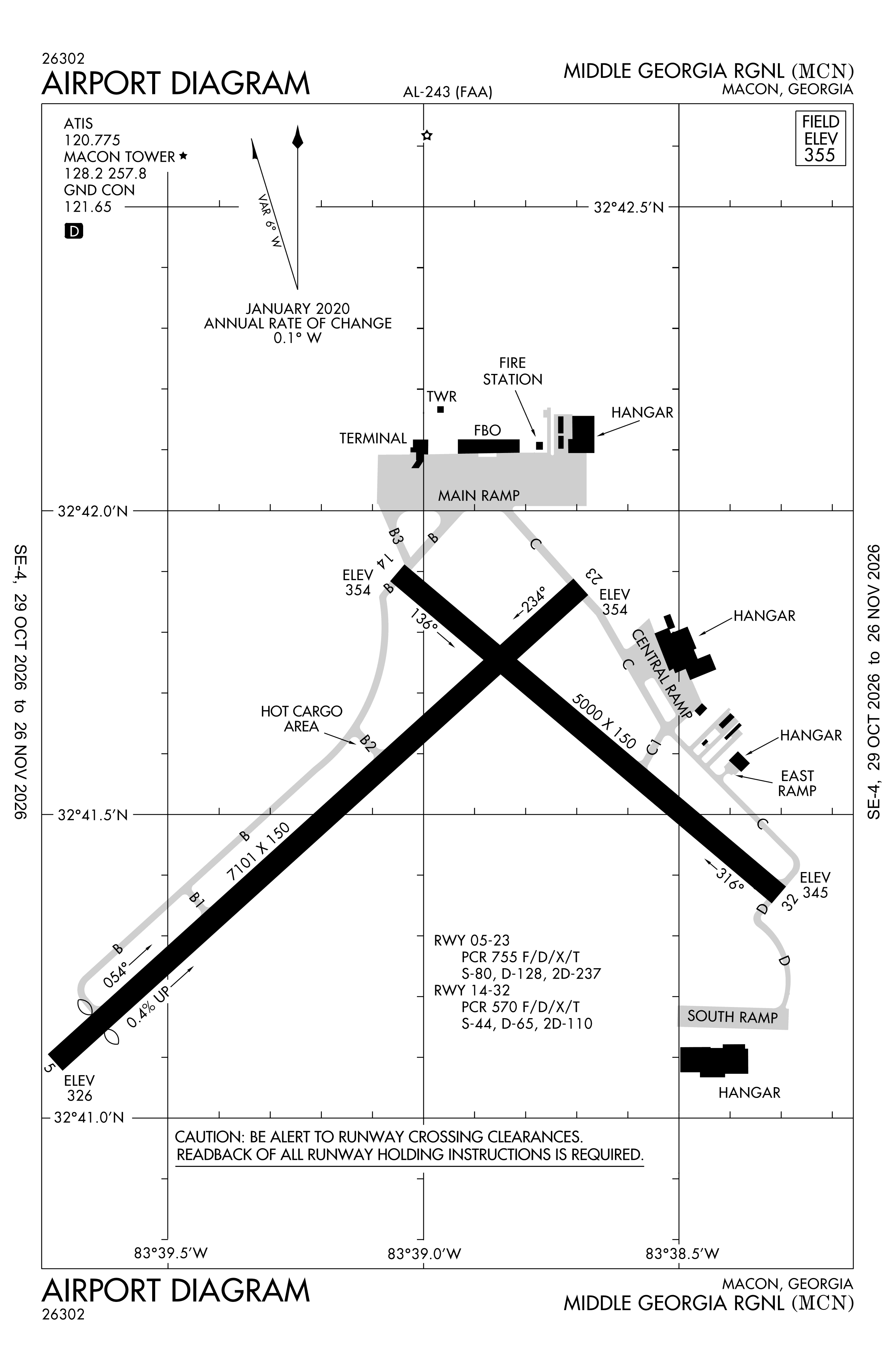
Official FAA PDF (effective Oct 29 to Nov 26)
FAA airport diagram, cycle 2611, effective Oct 29 to Nov 26, 2026. Reference only, not for navigation.
FBOs and services
FBOs
No FBOs are listed in OpenStreetMap for this airport.
Not listed? The FBO may not be in OpenStreetMap. Send a correction.
Data © OpenStreetMap contributors (ODbL), as of Nov 3, 2026.
Related
- Interactive NOTAM search for KMCN (category filters, maps, share links and a NOTAM decoder)
- Middle Georgia Regional Airport: codes, map and current weather
- MCN weather and runway winds (METAR and TAF in plain English)
- Flights at MCN now
- NOTAMs for other US airports
More NOTAMs in Georgia
Times are UTC (Z). Plain-English explanations are generated by cwsi.net from the NOTAM abbreviations and may simplify; the original NOTAM text is authoritative. NOTAMs come from the FAA NOTAM Management Service; cwsi.net refreshes its copy every 3 minutes. cwsi.net is not affiliated with the FAA: always confirm NOTAMs through official sources (a standard briefing or FAA NOTAM Search) before flight.