TYS NOTAMs
McGhee Tyson Airport, Knoxville, TN · KTYS
McGhee Tyson Airport in Knoxville, Tennessee (IATA TYS, ICAO KTYS) has 24 current NOTAMs (Notices to Air Missions): 24 in effect now and 0 starting later. By category: navaids (6), procedures (5) and taxiways (5). The list comes from the FAA NOTAM Management Service, refreshed by cwsi.net every few minutes; each NOTAM shows its number, category, start and end time in UTC, and a plain-English reading.
- Navaid6
- Procedures5
- Taxiway5
- Runway4
- Apron1
- Communications1
- Obstacle1
- Other1
In effect now (24)
IAP MC GHEE TYSON, KNOXVILLE, TN. RNAV (GPS) RWY 23L, AMDT 2A... LPV DA 1237/HAT 272 ALL CATS. VIS RVR 4500 ALL CATS. TEMPORARY CRANES, UP TO 1190 MSL, BEGINNING 3579FT SOUTH OF RWY 23L (2023-ASO-12096 THRU 12100-NRA). 2611121417-2701201417EST
COM REMOTE TRANS/REC 132.8 NOT AVBL 2611101131-2612232359EST
M0007/26 NOTAMN Q) ZTL/QFFCG/IV/NBO/A/000/999/3548N08359W005 A) KTYS B) 2611061413 C) 2612312100 E) AIR NTL GUARD LOWER RAMP - ANG RAMPS, ARFF CPBLTY RDCD TO 84%
NAV ILS RWY 23L U/S 2611031008-2611192359
NAV ILS RWY 23L U/S 2611021117-2611192359EST
TWY A LGT ALL U/S EXC MEDIUM INTST ON CONS 2610310422-2611302359
RWY 05L/23R CL MARKINGS NE SIDE OBSC 2610300818-2701012100
RWY 05R/23L CLSD 2610300819-2612012359
TWY B LGT U/S EXC MEDIUM INTST ON CONS 2610291910-2612302100
TWY S CL MARKINGS NOT STD 2610291845-2612302100
TWY A1, A2, A3, A7, A8, TWY A BTN TWY A1 AND TWY C CLSD 2610291842-2612302330
OBST TOWER LGT (ASR 1043648) 355825.70N0841044.30W (13.2NM NW TYS) 1344.2FT (286.1FT AGL) U/S 2610121606-2701100400
APRON AIR NTL GUARD LOWER RAMP CLSD LGTD AND BARRICADED 2609291552-2612182100
RWY 05L LEAD OFF CL MARKINGS AT TWY B6 AND TWY G4 OBSC 2609232248-2611272100
RWY 23R LEAD OFF CL MARKINGS AT TWY B2 AND TWY G3 OBSC 2609232247-2611272100
NAV ILS RWY 23R OM NOT MNT 2609211530-2611232359EST
NAV VOT U/S 2607062143-2701072111EST
NAV ILS RWY 05L OM U/S 2606021545-2612302300EST
NAV ILS RWY 23R MM U/S 2606021542-2612302359EST
TWY S WIP CONSTRUCTION ADJ 2605151807-2611272100
ODP MC GHEE TYSON, KNOXVILLE, TN. TAKEOFF MINIMUMS AND (OBSTACLE) DEPARTURE PROCEDURES AMDT 9... TAKE-OFF MINIMUMS: RWY 5L, 300-1 3/4 OR STANDARD WITH A MINIMUM CLIMB OF 240 FEET PER NM TO 1300. ALL OTHER DATA REMAINS AS PUBLISHED. 2511242035-2711242035EST
SID MC GHEE TYSON, KNOXVILLE, TN. KNOXVILLE SEVEN DEPARTURE... TAKE-OFF MINIMUMS: RWY 05L/5R, STANDARD WITH MINIMUM CLIMB OF 250 FT PER NM TO 3200. ALL OTHER DATA REMAINS AS PUBLISHED. 2511242034-2711242033EST
IAP MC GHEE TYSON, KNOXVILLE, TN. ILS OR LOC RWY 23L, ORIG-A... S-ILS 23L DA 1237/HAT 272 ALL CATS. VIS RVR 4500 ALL CATS. S-LOC 23L MDA 1420/HAT 455 ALL CATS. VIS CAT C/D 1 3/8. VDP AT 2.86 DME; DISTANCE VDP TO THLD 1.28 NM. TEMPORARY CRANES, UP TO 1190 MSL, BEGINNING 3579FT SOUTH OF RWY 23L (2023-ASO-12096 THRU 12100-NRA). TEMPORARY CRANES 1169 MSL 4046FT SW OF RWY 23L (2023-ASO-12082/12085-NRA). 2510171716-2702141716EST
IAP U.S. DOD MC GHEE TYSON, KNOXVILLE, TN. HI-ILS OR LOC RWY 23L, ORIG-A... S-ILS 23L CAT C/D/E DA 1237/HAT 272, VIS CAT C/D/E RVR 4500. S-LOC 23L CAT C/D/E MDA 1420/HAT 455. VIS CAT C/D/E 1 3/8. VDP AT 2.86 DME; DISTANCE VDP TO THLD 1.28 NM. TEMPORARY CRANES, UP TO 1190 MSL, BEGINNING 3579FT SOUTH OF RWY 23L (2023-ASO-12096 THRU 12100-NRA). TEMPORARY CRANES 1169 MSL 4046FT SW OF RWY 23L (2023-ASO-12082/12085-NRA). 2510171716-2702141716EST
Airport diagram

FAA chart (PNG) Official FAA PDF (effective Oct 29 to Nov 26)
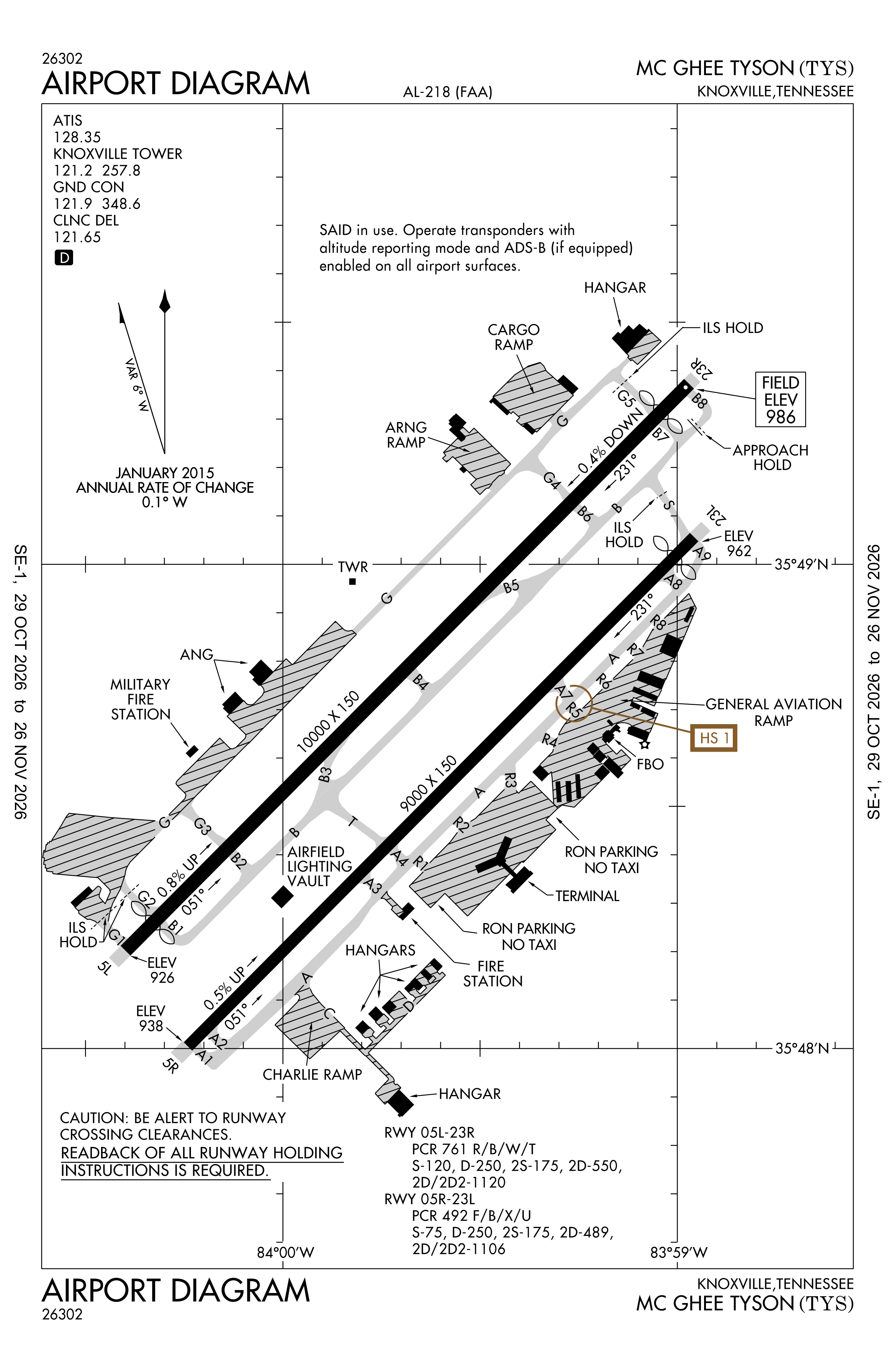
Redrawn by cwsi.net from the FAA airport diagram, cycle 2611, effective Oct 29 to Nov 26, 2026, and OpenStreetMap. Reference only, not for navigation.
FBOs and services
FBOs
 Signature Knoxville2343 W General Aviation Drive, Alcoa, TN 37701+1 865-970-9000Hours: 24 hours a day/7 days a weekUNICOM 122.95ARINC 128.95Signature page
FBO details may be out of date. Call ahead to confirm services and hours.
Not listed? Send a correction.
As of Nov 5, 2026.
Related
- Interactive NOTAM search for KTYS (category filters, maps, share links and a NOTAM decoder)
- McGhee Tyson Airport: codes, map and current weather
- TYS weather and runway winds (METAR and TAF in plain English)
- Flights at TYS now
- NOTAMs for other US airports
More NOTAMs in Tennessee
Times are UTC (Z). Plain-English explanations are generated by cwsi.net from the NOTAM abbreviations and may simplify; the original NOTAM text is authoritative. NOTAMs come from the FAA NOTAM Management Service; cwsi.net refreshes its copy every 3 minutes. cwsi.net is not affiliated with the FAA: always confirm NOTAMs through official sources (a standard briefing or FAA NOTAM Search) before flight.