CHA NOTAMs
Chattanooga Metropolitan Airport, Chattanooga, TN · KCHA
Chattanooga Metropolitan Airport in Chattanooga, Tennessee (IATA CHA, ICAO KCHA) has 17 current NOTAMs (Notices to Air Missions): 15 in effect now and 2 starting later. By category: obstacles (5), runways (5) and navaids (3). The list comes from the FAA NOTAM Management Service, refreshed by cwsi.net every few minutes; each NOTAM shows its number, category, start and end time in UTC, and a plain-English reading.
- Obstacle5
- Runway5
- Navaid3
- Taxiway3
- Procedures1
In effect now (15)
OBST TOWER LGT (ASR 1019085) 350254.00N0851626.00W (3.5NM WNW CHA) 848.1FT (203.1FT AGL) U/S 2611131722-2612132359
OBST TOWER LGT (ASR 1037142) 351633.30N0851105.90W (14.5NM NE CHA) 1980.0FT (379.9FT AGL) U/S 2611040640-2611190540
TWY D BTN FIXED BASE OPR EAST RAMP AND TERMINAL RAMP CLSD EXC GA 2610271740-2611202359
TWY C BTN TWY D AND RWY 15/33 CLSD LGTD AND BARRICADED 2610271740-2611202359
RWY 02/20 CL MARKINGS OBSC 2610241437-2705312359
OBST TOWER LGT (ASR 1043397) 350514.50N0852149.70W (8.4NM WNW CHA) 1987.2FT (260.2FT AGL) U/S 2609300818-2612290918
OBST TOWER LGT (ASR 1042155) 350733.50N0851724.80W (6.9NM NW CHA) 1518.0FT (575.1FT AGL) U/S 2609290359-2612280459
TWY A EDGE MARKINGS BTN APCH END RWY 02 AND TWY G EAST SIDE NOT MARKED 60FT 2609281947-2612312359
RWY 02 LEAD OFF CL MARKINGS AT TWY D OBSC 2609281916-2612312359
RWY 20 LEAD OFF CL MARKINGS AT TWY F OBSC 2609281916-2612312359
RWY 20 LEAD OFF CL MARKINGS AT TWY G OBSC 2609281916-2612312359
NAV ILS RWY 02 OM U/S 2609231601-2612312359EST
OBST TOWER LGT (ASR UNKNOWN) 35625.87N0851357.08W (4.62NM N CHA) 946FT (265FT AGL) U/S 2606140722-2706142359
RWY 02 ALS U/S 2603030407-2611272000EST
NAV ILS RWY 20 OM U/S 2603021317-2704192111EST
Starting later (2)
SID LOVELL FLD, CHATTANOOGA, TN. CHATTANOOGA NINE DEPARTURE... SHELBYVILLE TRANSITION NA EXCEPT FOR ACFT EQUIPPED WITH SUITABLE RNAV SYSTEM WITH GPS, SYI VOR/DME OUT OF SERVICE. 2611171400-2611172000EST
NAV ILS RWY 20 U/S 2611171400-2611172000
Airport diagram

FAA chart (PNG) Official FAA PDF (effective Oct 29 to Nov 26)
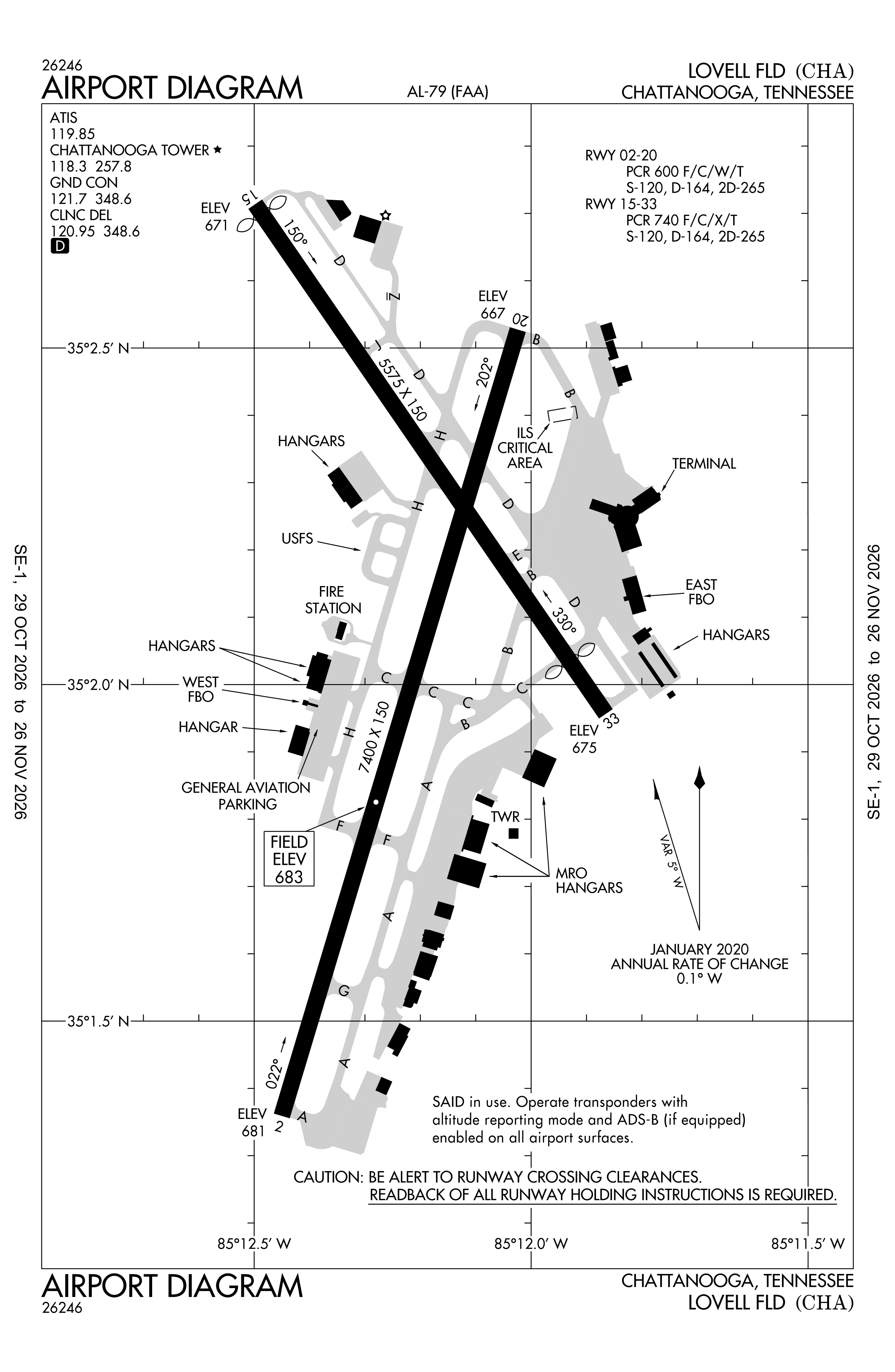
Redrawn by cwsi.net from the FAA airport diagram, cycle 2611, effective Oct 29 to Nov 26, 2026, and OpenStreetMap. Reference only, not for navigation.
FBOs and services
FBOs
- Wilson Air Centerwilsonair.com
FBO details may be out of date. Call ahead to confirm services and hours.
Not listed? Send a correction.
As of Nov 3, 2026.
Related
- Interactive NOTAM search for KCHA (category filters, maps, share links and a NOTAM decoder)
- Chattanooga Metropolitan Airport: codes, map and current weather
- CHA weather and runway winds (METAR and TAF in plain English)
- Flights at CHA now
- NOTAMs for other US airports
More NOTAMs in Tennessee
Times are UTC (Z). Plain-English explanations are generated by cwsi.net from the NOTAM abbreviations and may simplify; the original NOTAM text is authoritative. NOTAMs come from the FAA NOTAM Management Service; cwsi.net refreshes its copy every 3 minutes. cwsi.net is not affiliated with the FAA: always confirm NOTAMs through official sources (a standard briefing or FAA NOTAM Search) before flight.