STC NOTAMs
St. Cloud Regional Airport, St. Cloud, MN · KSTC
St. Cloud Regional Airport in St. Cloud, Minnesota (IATA STC, ICAO KSTC) has 11 current NOTAMs (Notices to Air Missions): 11 in effect now and 0 starting later. By category: obstacles (4), procedures (4) and navaids (3). The list comes from the FAA NOTAM Management Service, refreshed by cwsi.net every few minutes; each NOTAM shows its number, category, start and end time in UTC, and a plain-English reading.
- Obstacle4
- Procedures4
- Navaid3
In effect now (11)
OBST TOWER LGT (ASR 1026461) 453104.90N0941955.00W (11.6NM W STC) 1504.9FT (315.0FT AGL) U/S 2611050638-2611200538
IAP ST CLOUD SKY CENTRAL, ST CLOUD, MN. VOR RWY 31, ORIG-D... S-31 MDA 1500/HAT 480 ALL CATS, CAT C VIS 1. FOR ALS INOP, INCREASE S-31 CAT C/D VISIBILITY 1 3/8 SM. TEMPORARY CRANE 1181 MSL 7353FT E OF RWY 31 (2026-AGL-5692-OE). 2610281811-2612111811EST
OBST TOWER LGT (ASR 1023850) 453336.00N0940821.00W (3.5NM W STC) 1508FT (481FT AGL) U/S 2610270151-2612110751
OBST TOWER LGT (ASR 1251333) 452416.30N0941406.00W (11.3NM SW STC) 1382.9FT (259.8FT AGL) U/S 2610240315-2702210315
OBST TOWER LGT (ASR 1026461) 453104.90N0941955.00W (11.6NM W STC) 1504.9FT (315.0FT AGL) U/S 2610220812-2611060712
NAV ILS RWY 31 HUSSK LOM U/S 2608261855-2706012000EST
NAV ILS RWY 31 MM U/S 2607211704-PERM
ODP ST CLOUD SKY CENTRAL, ST CLOUD, MN. TAKEOFF MINIMUMS AND (OBSTACLE) DEPARTURE PROCEDURES ORIG... TAKEOFF OBSTACLE NOTES: RWY 5, TRANSMISSION LINE TOWER, 6221FT FROM DER, 807FT LEFT OF CENTERLINE, 137 AGL/1159 MSL (2025-AGL-8731-OE). TRANSMISSION LINE TOWER, 6289FT FROM DER, 275FT LEFT OF CENTERLINE, 162 AGL/1161 MSL (2025-AGL-8732-OE). TRANSMISSION LINE TOWER, 6379FT FROM DER, 390FT RIGHT OF CENTERLINE, 147 AGL/1161 MSL (2025-AGL-8733-OE). ALL OTHER DATA REMAINS AS PUBLISHED. 2607082329-2807082329EST
NAV ILS RWY 31 OM U/S 2606121234-2706012111EST
ODP ST CLOUD RGNL, ST CLOUD, MN. TAKEOFF MINIMUMS AND (OBSTACLE) DEPARTURE PROCEDURES ORIG... TEXTUAL DEPARTURE PROCEDURE TAKEOFF MINIMUMS RWY 5: 300-1 1/4 OR STANDARD WITH MINIMUM CLIMB OF 203 FT/NM TO 1300 OR ALTERNATIVELY, WITH STANDARD TAKEOFF MINIMUMS AND A NORMAL 200 FT/NM CLIMB GRADIENT, TAKEOFF MUST OCCUR NO LATER THAN 1200 FEET PRIOR TO DER. 2603061423-2803061423EST
IAP ST CLOUD RGNL, ST CLOUD, MN. ILS OR LOC RWY 31, AMDT 4A... AUTOPILOT COUPLED APPROACH NA BELOW 1600. 2601091601-2801091601EST
Airport diagram
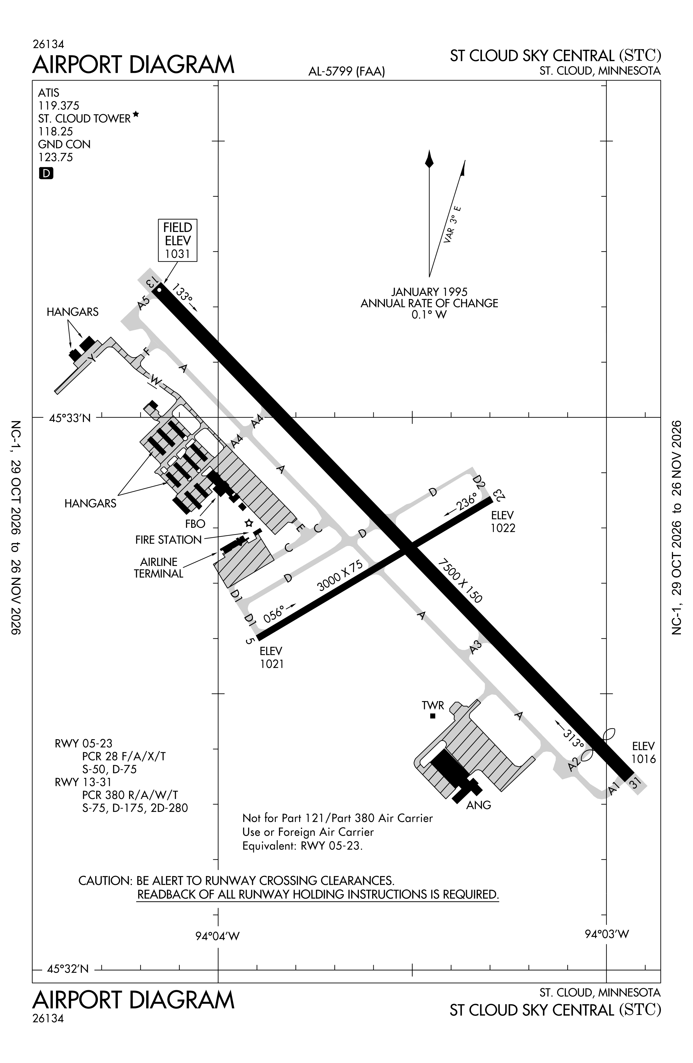
Official FAA PDF (effective Oct 29 to Nov 26)
FAA airport diagram, cycle 2611, effective Oct 29 to Nov 26, 2026. Reference only, not for navigation.
FBOs and services
FBOs
No FBOs are listed in OpenStreetMap for this airport.
Not listed? The FBO may not be in OpenStreetMap. Send a correction.
Data © OpenStreetMap contributors (ODbL), as of Nov 3, 2026.
Related
- Interactive NOTAM search for KSTC (category filters, maps, share links and a NOTAM decoder)
- St. Cloud Regional Airport: codes, map and current weather
- STC weather and runway winds (METAR and TAF in plain English)
- Flights at STC now
- NOTAMs for other US airports
More NOTAMs in Minnesota
Times are UTC (Z). Plain-English explanations are generated by cwsi.net from the NOTAM abbreviations and may simplify; the original NOTAM text is authoritative. NOTAMs come from the FAA NOTAM Management Service; cwsi.net refreshes its copy every 3 minutes. cwsi.net is not affiliated with the FAA: always confirm NOTAMs through official sources (a standard briefing or FAA NOTAM Search) before flight.