RST NOTAMs
Rochester International Airport, Rochester, MN · KRST
Rochester International Airport in Rochester, Minnesota (IATA RST, ICAO KRST) has 29 current NOTAMs (Notices to Air Missions): 28 in effect now and 1 starting later. By category: obstacles (10), taxiways (9) and runways (7). The list comes from the FAA NOTAM Management Service, refreshed by cwsi.net every few minutes; each NOTAM shows its number, category, start and end time in UTC, and a plain-English reading.
- Obstacle10
- Taxiway9
- Runway7
- Apron2
- Services1
In effect now (28)
TWY ALL FICON WET OBS AT 2611051032. 2611051032-2611061032
APRON ALL FICON WET OBS AT 2611051032. 2611051032-2611061032
RWY 31 FICON 5/5/5 100 PCT WET OBS AT 2611051032. 2611051032-2611061032
TWY ALL FICON WET OBS AT 2611050307. 2611050307-2611060307
APRON ALL FICON WET OBS AT 2611050307. 2611050307-2611060307
RWY 31 FICON 5/5/5 100 PCT WET OBS AT 2611050306. 2611050306-2611060306
OBST TOWER LGT (ASR 1029133) 440228.00N0922026.00W (10.5NM NE RST) 2239.2FT (993.1FT AGL) U/S 2610280435-2611112359
TWY A BTN RWY 03/21 AND TWY D CLSD 2610191558-2611202300
TWY E CLSD 2610191557-2611202300
TWY F CLSD TO ACFT WINGSPAN MORE THAN 117FT AND ACFT MORE THAN 110000LB 2610191556-2611202300
TWY G CLSD TO ACFT WINGSPAN MORE THAN 117FT AND ACFT MORE THAN 110000LB 2610191556-2611202300
TWY D CLSD 2610191555-2611202300
OBST TOWER LGT (ASR 1021982) 440349.00N0922112.00W (11.3NM NE RST) 1564.0FT (326.1FT AGL) U/S 2610150930-2612142359
OBST TOWER LGT (ASN 2026-AGL-1050-OE) 435658N0921543W (10.6NM ENE RST) 1495FT (199FT AGL) U/S 2610131949-2701112359
OBST TOWER LGT (ASR 1237547) 435050.90N0922935.60W (3.7NM S RST) 1538.1FT (310.0FT AGL) U/S 2610081606-2611082300
TWY B, B1, B2, B3 CLSD 2610061416-2709302300
RWY 21 PAPI U/S 2610061415-2709302300
RWY 03/21 CLSD 2610061414-2709302300
RWY 21 RWY END ID LGT U/S 2610061413-2709302300
OBST CRANE (ASN 2026-AGL-2920-OE) 440121N0922807W (7NM NE RST) 1556FT (552FT AGL) LGTD 2608202120-2612312359
OBST CRANE (ASN 2026-AGL-2909-OE) 440119N0922803W (7NM NNE RST) 1551FT (544FT AGL) LGTD 2608202118-2612312359
RWY 03 VASI DECOMMISSIONED 2607220542-PERM
RWY 03 RWY END ID LGT DECOMMISSIONED 2607220533-PERM
TWY J CLSD 2607081500-2612312300
OBST CRANE (ASN UNKNOWN ) 440121N0922810W (6NM N RST) 1305FT (285FT AGL) LGTD 2604131100-2704132359
OBST CRANE (ASN UNKNOWN ) 440119N0922806W (6.1NM N RST) 1341FT (335FT AGL) LGTD 2604131100-2704132359
OBST CRANE (ASN UNKNOWN ) 440118N0922810W (5.9NM N RST) 1388FT (367FT AGL) LGTD 2604131100-2704072359
OBST CRANE (ASN UNKNOWN ) 440120N0922814W (6.4NM N RST) 1357FT (333FT AGL) LGTD 2604131100-2704132359
Starting later (1)
SVC TAR/SSR U/S 2611091300-2611092030
Airport diagram
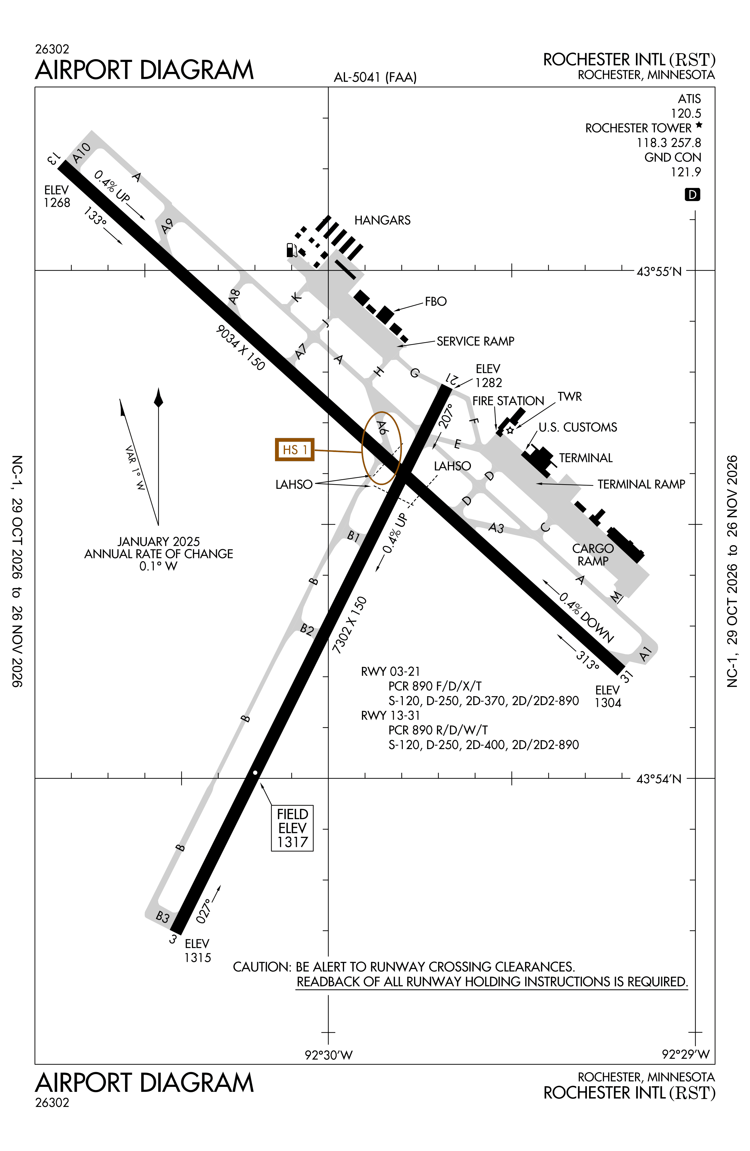
Official FAA PDF (effective Oct 29 to Nov 26)
FAA airport diagram, cycle 2611, effective Oct 29 to Nov 26, 2026. Reference only, not for navigation.
FBOs and services
FBOs
 Signature Rochester7300 Brataas Drive SW, Rochester, MN 55902+1 507-282-1717Hours: 24 hours a day/7 days a weekUNICOM 122.95Signature pageSource: Signature Aviation
FBO locations from the operators' own sites, may be out of date. Call ahead to confirm services and hours.
Not listed? The FBO may not be in OpenStreetMap. Send a correction.
Signature Aviation locations, as of Nov 5, 2026.
Related
- Interactive NOTAM search for KRST (category filters, maps, share links and a NOTAM decoder)
- Rochester International Airport: codes, map and current weather
- RST weather and runway winds (METAR and TAF in plain English)
- Flights at RST now
- NOTAMs for other US airports
More NOTAMs in Minnesota
Times are UTC (Z). Plain-English explanations are generated by cwsi.net from the NOTAM abbreviations and may simplify; the original NOTAM text is authoritative. NOTAMs come from the FAA NOTAM Management Service; cwsi.net refreshes its copy every 3 minutes. cwsi.net is not affiliated with the FAA: always confirm NOTAMs through official sources (a standard briefing or FAA NOTAM Search) before flight.