SIG NOTAMs
Fernando Luis Ribas Dominicci Airport, San Juan, PR · TJIG
Fernando Luis Ribas Dominicci Airport in San Juan, Puerto Rico (IATA SIG, ICAO TJIG) has 10 current NOTAMs (Notices to Air Missions): 10 in effect now and 0 starting later. By category: obstacles (5), procedures (3) and runways (2). The list comes from the FAA NOTAM Management Service, refreshed by cwsi.net every few minutes; each NOTAM shows its number, category, start and end time in UTC, and a plain-English reading.
- Obstacle5
- Procedures3
- Runway2
In effect now (10)
OBST TOWER LGT (ASR 1274074) 181255.60N0661657.90W (18.8NM SW SIG) 2278.2FT (261.2FT AGL) U/S 2611041922-2702021922
OBST TOWER LGT (ASR 1253198) 182449.40N0661740.70W (11.9NM WSW SIG) 565.0FT (267.1FT AGL) U/S 2611040918-2702020918
OBST TOWER LGT (ASR 1306737) 182657.20N0660507.00W (0.9NM SE SIG) 188FT (176FT AGL) U/S 2610240213-2612080213
OBST TOWER LGT (ASN 2019-ASO-25013-OE) 181845N0661254W (11.5NM SW SIG) 757FT (210FT AGL) U/S 2609141552-2612132359
OBST TOWER LGT (ASR 1246976) 181141.10N0661510.00W (18.8NM SSW SIG) 1700.1FT (263.1FT AGL) U/S 2608220732-2611200832
IAP FERNANDO LUIS RIBAS DOMINICCI, SAN JUAN, PR. RNAV (GPS) RWY 9, ORIG-A... PROCEDURE NA AT NIGHT. CHANGE NOTE TO READ: RWY 9 HELICOPTER VISIBILITY REDUCTION BELOW 1 SM NA (2022-ASO-46579 THRU 46589/46615-OE PERM). 2607072133-2807072133EST
ODP FERNANDO LUIS RIBAS DOMINICCI, SAN JUAN, PR. TAKEOFF MINIMUMS AND (OBSTACLE) DEPARTURE PROCEDURES AMDT 1... TAKEOFF MINIMUMS: RWY 27, 300-1 1/8 WITH MINIMUM CLIMB OF 300 FT PER NM TO 1200 (2022-ASO-46606-OE PERM). ALL OTHER DATA REMAINS AS PUBLISHED. 2607072133-2807072133EST
ODP FERNANDO LUIS RIBAS DOMINICCI, SAN JUAN, PR. TAKEOFF MINIMUMS AND (OBSTACLE) DEPARTURE PROCEDURES AMDT 1... TAKE-OFF MINIMUMS RWY 09: 400-1 3/4 WITH MINIMUM CLIMB OF 400 FT/NM TO 2000. DEPARTURE ROUTE DESCRIPTION RWY 27: CLIMB ON HEADING 274.82 TO 1300 BEFORE TURNING SOUTH. ALL OTHER DATA REMAINS AS PUBLISHED. 2512081435-2712081435EST
RWY 09 PAPI U/S 2407112227-PERM
RWY 09/27 SAFETY AREA REDUCED BY ROAD E END CAUTION VEHICLE OBS 17 FT AGL 2401102320-PERM
Airport diagram
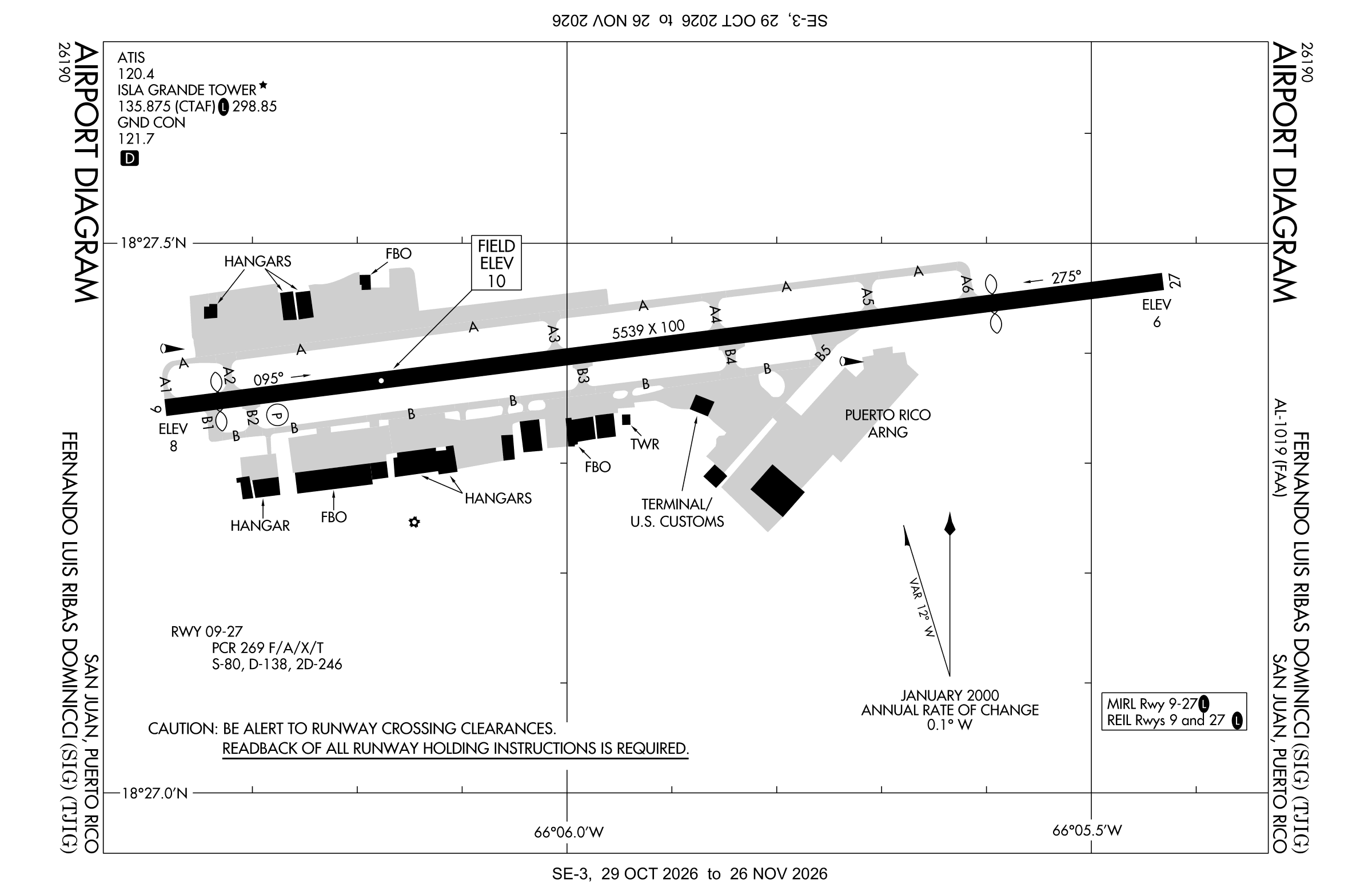
Official FAA PDF (effective Oct 29 to Nov 26)
FAA airport diagram, cycle 2611, effective Oct 29 to Nov 26, 2026. Reference only, not for navigation.
FBOs and services
FBOs
No FBOs are listed in OpenStreetMap for this airport.
Not listed? The FBO may not be in OpenStreetMap. Send a correction.
Data © OpenStreetMap contributors (ODbL), as of Nov 3, 2026.
Related
- Interactive NOTAM search for TJIG (category filters, maps, share links and a NOTAM decoder)
- Fernando Luis Ribas Dominicci Airport: codes, map and current weather
- SIG weather and runway winds (METAR and TAF in plain English)
- Flights at SIG now
- NOTAMs for other US airports
More NOTAMs in Puerto Rico
Times are UTC (Z). Plain-English explanations are generated by cwsi.net from the NOTAM abbreviations and may simplify; the original NOTAM text is authoritative. NOTAMs come from the FAA NOTAM Management Service; cwsi.net refreshes its copy every 3 minutes. cwsi.net is not affiliated with the FAA: always confirm NOTAMs through official sources (a standard briefing or FAA NOTAM Search) before flight.