SCK NOTAMs
Stockton Metropolitan Airport, Stockton, CA · KSCK
Stockton Metropolitan Airport in Stockton, California (IATA SCK, ICAO KSCK) has 18 current NOTAMs (Notices to Air Missions): 16 in effect now and 2 starting later. By category: procedures (6), runways (5) and obstacles (3). The list comes from the FAA NOTAM Management Service, refreshed by cwsi.net every few minutes; each NOTAM shows its number, category, start and end time in UTC, and a plain-English reading.
- Procedures6
- Runway5
- Obstacle3
- Aerodrome1
- Navaid1
- Services1
- Taxiway1
In effect now (16)
SVC TAR/SSR U/S 2611050006-2611122359
RWY 11L TWY DIRECTION SIGN AT TWY D LEFT SIDE LGT U/S 2611020410-2611062330
OBST TOWER LGT (ASN 2026-AWP-1410-NRA) 375340N1211419W (0.0NM N SCK) 25FT (1FT AGL) U/S 2611020141-2611100100
RWY 11L 2000FT DIST REMAINING SIGN LGT U/S 2610310309-2611062330
RWY 29R 8000FT DIST REMAINING SIGN LGT U/S 2610310309-2611062330
TWY B2 HLDG PSN SIGN FOR RWY 11L/29R LGT U/S 2610310308-2611062330
OBST TOWER LGT (ASR 1014924) 375856.00N1211346.00W (5.3NM N SCK) 239FT (206FT AGL) U/S 2610140151-2611280151
ODP STOCKTON METRO, STOCKTON, CA. TAKEOFF MINIMUMS AND (OBSTACLE) DEPARTURE PROCEDURES AMDT 1... ADD TAKEOFF OBSTACLE NOTE: RWY 29L, TEMP CRANE 179FT FROM DER, 324 LEFT OF CENTERLINE, UP TO 100 AGL/123 MSL (2026-AWP-1029-NRA). ALL OTHER DATA REMAINS AS PUBLISHED. 2609241549-2705061549EST
IAP STOCKTON METRO, STOCKTON, CA. RNAV (GPS) RWY 11L, AMDT 1A... LPV DA 291/HAT 262 ALL CATS. TEMP CRANE 123 MSL, 425FT W OF RWY 11R (2026-AWP-1029-NRA). 2609241526-2705061526EST
OBST TOWER LGT (ASR 1013410) 374633.00N1210622.30W (9.6NM SE SCK) 280.8FT (213.9FT AGL) U/S 2609011248-2611301348
RWY 11L/29R SAFETY AREA NOT STANDARD SW EDGE 2608202029-2612312300
RWY 11L/29R SAFETY AREA NOT STD N EDGE 2608202029-2612312359
IAP STOCKTON METRO, STOCKTON, CA. ILS OR LOC RWY 29R, AMDT 22A... CIRCLING CAT A/B MDA 560/HAA 527. WIGBI FIX MINIMUMS (DUAL VOR RECEIVERS OR DME REQUIRED) CIRCLING CAT A/B MDA 560/HAA 527. TEMPORARY CRANE 201 MSL 1 NM EAST OF RWY 29R (2026-AWP-4466-OE). 2605011826-2612111826EST
IAP STOCKTON METRO, STOCKTON, CA. RNAV (GPS) RWY 29R, AMDT 2... LNAV/VNAV DA 440/HAT 408 ALL CATS, VISIBILITY ALL CATS RVR 4000. LNAV MDA440/HAT 408 ALL CATS, VISIBILITY CATS C/D RVR 4000. CIRCLING CAT A/B MDA 560/HAA 527. VDP NA. TEMPORARY CRANE 201 MSL 1 NM EAST OF RWY 29R (2026-AWP-4466-OE). 2605011825-2612111825EST
IAP STOCKTON METRO, STOCKTON, CA. RNAV (GPS) RWY 11L, AMDT 1A... CIRCLING CAT A/B MDA 560/HAA 527. TEMPORARY CRANE 201 MSL 1.9NM SE OF SCK AIRPORT (2026-AWP-4466-OE). 2605011824-2612111824EST
IAP STOCKTON METRO, STOCKTON, CA. RNAV (GPS) RWY 29R, AMDT 2... LNAV MDA 440/HAT 408 ALL CATS, VISIBILITY CATS C/D RVR 4000. VDP NA.. 2603200008-2803200006EST
Starting later (2)
NAV ILS RWY 29R CAT II NA 2611051600-2611060300
AD AP RVR ALL U/S 2611051600-2611060300
Airport diagram
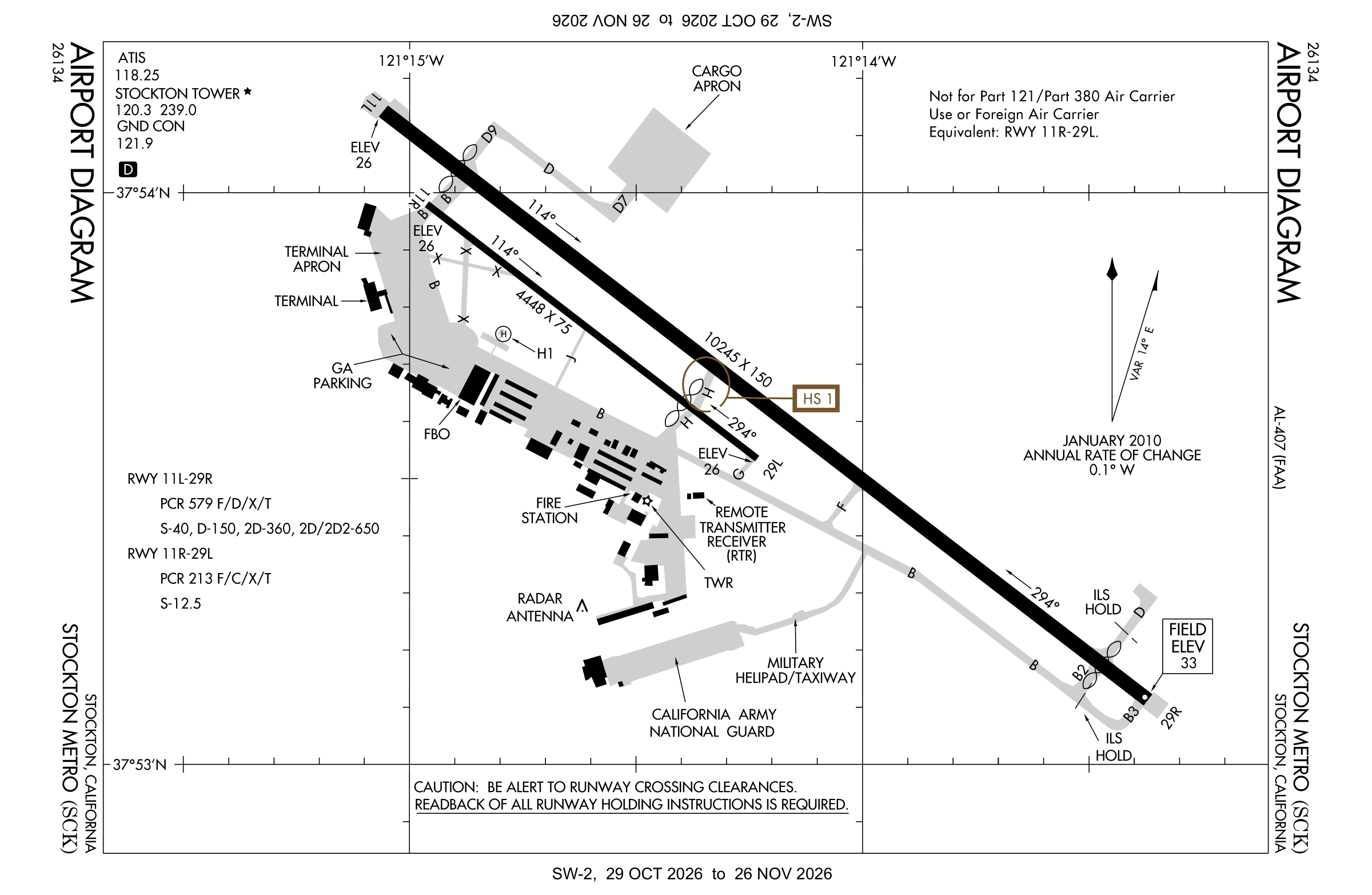
Official FAA PDF (effective Oct 29 to Nov 26)
FAA airport diagram, cycle 2611, effective Oct 29 to Nov 26, 2026. Reference only, not for navigation.
FBOs and services
FBOs
 Atlantic Aviation Stockton6364 S. Lindbergh St., Stockton, CA+1 209-982-1622Hours: Mon-Sun: 0500-2100Atlantic pageSource: Atlantic Aviation
FBO locations from the operators' own sites, may be out of date. Call ahead to confirm services and hours.
Not listed? The FBO may not be in OpenStreetMap. Send a correction.
Atlantic Aviation locations, as of Nov 5, 2026.
Related
- Interactive NOTAM search for KSCK (category filters, maps, share links and a NOTAM decoder)
- Stockton Metropolitan Airport: codes, map and current weather
- SCK weather and runway winds (METAR and TAF in plain English)
- Flights at SCK now
- NOTAMs for other US airports
More NOTAMs in California
Times are UTC (Z). Plain-English explanations are generated by cwsi.net from the NOTAM abbreviations and may simplify; the original NOTAM text is authoritative. NOTAMs come from the FAA NOTAM Management Service; cwsi.net refreshes its copy every 3 minutes. cwsi.net is not affiliated with the FAA: always confirm NOTAMs through official sources (a standard briefing or FAA NOTAM Search) before flight.