MSN NOTAMs
Dane County Regional Airport, Madison, WI · KMSN
Dane County Regional Airport in Madison, Wisconsin (IATA MSN, ICAO KMSN) has 16 current NOTAMs (Notices to Air Missions): 14 in effect now and 2 starting later. By category: procedures (5), taxiways (4) and aprons (3). The list comes from the FAA NOTAM Management Service, refreshed by cwsi.net every few minutes; each NOTAM shows its number, category, start and end time in UTC, and a plain-English reading.
- Procedures5
- Taxiway4
- Apron3
- Obstacle2
- Navaid1
- Other1
In effect now (14)
M0038/26 NOTAMN Q) ZAU/QFAAM/IV/NBO/A/000/999/4308N08920W005 A) KMSN B) 2611161938 C) 2702042359 E) HI-TACAN TO ALL RUNWAYS FOR F-35 ACFT PROHIBITED DUE TO SIGNIFICANT COURSE DEVIATION
OBST CRANE (ASN 2026-AGL-15566-OE) 430733N0892002W (0.9NM S MSN) 958FT (102FT AGL) FLAGGED AND LGTD 2611121340-2611202300
TWY B TWY DIRECTION SIGN LGT U/S 2611070919-2611302359
APRON EAST RAMP BTN TWY H AND TWY J SFC MARKINGS REMOVED 2610301137-2611302359
TWY B TWY DIRECTION SIGN FOR TWY B5 LGT U/S 2610301058-2611302359
NAV ILS RWY 21 NOT MNT 2610261159-2612182000EST
IAP U.S. DOD DANE COUNTY RGNL/TRUAX FLD, MADISON, WI. HI - TACAN RWY 18, AMDT 1B... S-18 CAT C/D/E MDA 1400/HAT 536. 2610231850-2810231850EST
OBST TOWER LGT (ASR 1047790) 430358.00N0891826.20W (4.6NM S MSN) 1141FT (221FT AGL) U/S 2610201406-2701172359
APRON EAST RAMP NONMOVEMENT AREA BDRY MARKINGS SE SIDE NOT MARKED 2610141242-2611302300
TWY E BTN EAST RAMP AND RWY 14/32, TWY H BTN EAST RAMP AND APCH END RWY 32 SFC MARKINGS NOT STD 2610141239-2611302300
IAP DANE COUNTY RGNL/TRUAX FLD, MADISON, WI. RNAV (GPS) RWY 3, ORIG-E... ADD PROFILE VIEW NOTE: VGSI AND RNAV GLIDEPATH NOT COINCIDENT (VGSI ANGLE 3.00/TCH 49). 2610081339-2810050901EST
IAP DANE COUNTY RGNL/TRUAX FLD, MADISON, WI. RNAV (GPS) RWY 3, ORIG-E... LPV DA 1141/HAT 281 ALL CATS. VIS 7/8 ALL CATS. TEMPORARY CRANE, 1007 MSL, 1108FT EAST OF RWY 3 (2024-AGL-15586-NRA). 2609111525-2704231525EST
IAP DANE COUNTY RGNL/TRUAX FLD, MADISON, WI. RNAV (GPS) RWY 3, ORIG-E... LPV DA 1141/HAT 281 ALL CATS. VIS 7/8 ALL CATS. LNAV/VNAV DA 1263/HAT 403 ALL CATS. VIS 1 1/8 ALL CATS. TEMPORARY CRANES, UP TO 1052 MSL, BEGINNING 3947FT SW OF RWY 3 (2024-AGL-16443 THRU 16446-OE) , TEMPORARY CRANE, 1007 MSL, 1108FT EAST OF RWY 3 (2024-AGL-15586-NRA). 2608121744-2703242355EST
IAP DANE COUNTY RGNL/TRUAX FLD, MADISON, WI. ILS OR LOC RWY 21, AMDT 1... AUTOPILOT COUPLED APPROACH NA BELOW 1263. 2605141439-2803271422EST
Starting later (2)
APRON EAST RAMP BTN TWY M AND 400FT SE OF TWY M CLSD 2611171300-2611172300
TWY M BTN TWY M3 AND EAST RAMP CLSD 2611171300-2611172300
Airport diagram

FAA chart (PNG) Official FAA PDF (effective Oct 29 to Nov 26)
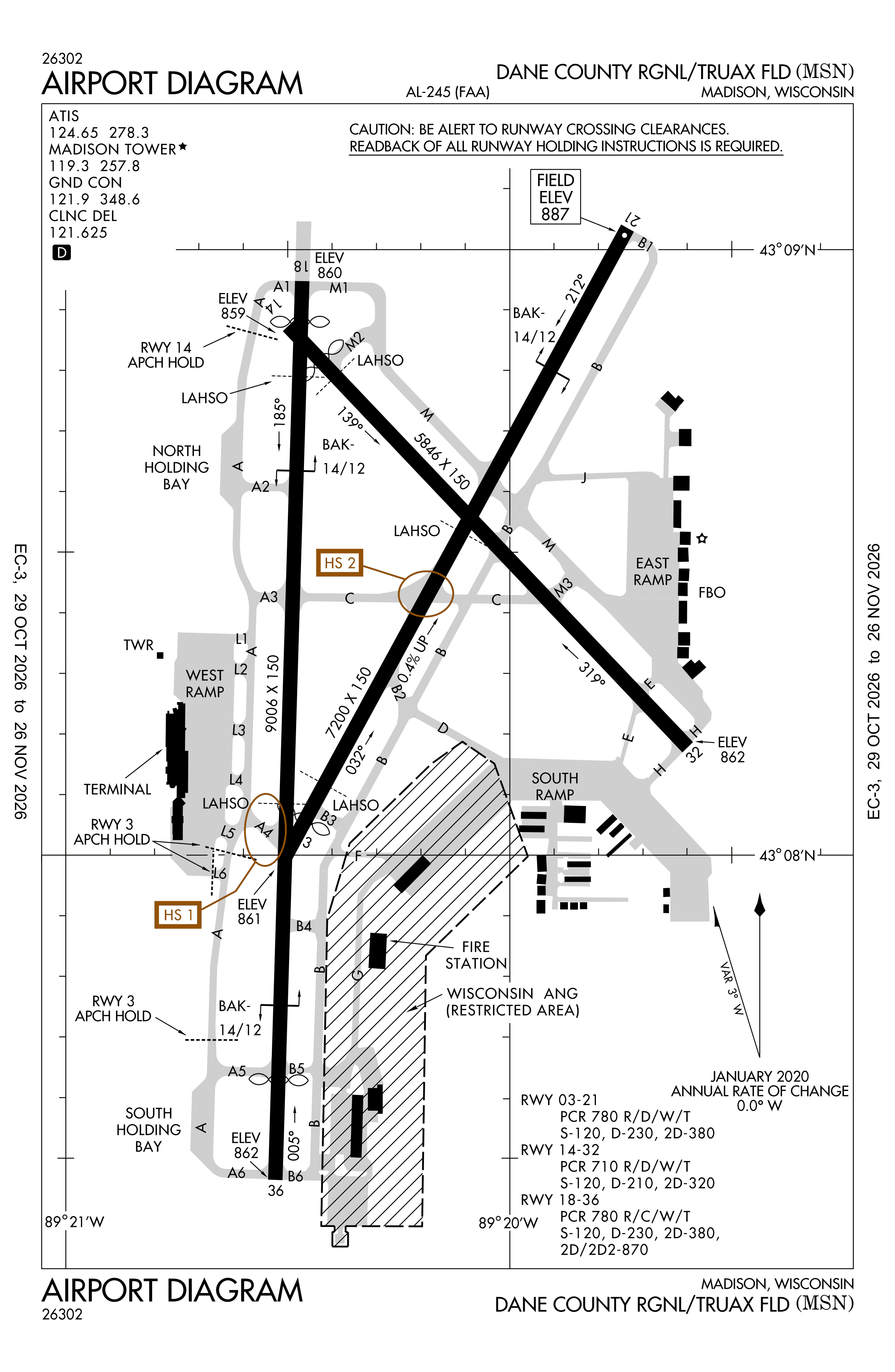
Redrawn by cwsi.net from the FAA airport diagram, cycle 2611, effective Oct 29 to Nov 26, 2026, and OpenStreetMap. Reference only, not for navigation.
FBOs and services
FBOs
- Wisconsin Aviation FBO+1 608-268-5000wisconsinaviation.com
FBO details may be out of date. Call ahead to confirm services and hours.
Not listed? Send a correction.
As of Nov 3, 2026.
Related
- Interactive NOTAM search for KMSN (category filters, maps, share links and a NOTAM decoder)
- Dane County Regional Airport: codes, map and current weather
- MSN weather and runway winds (METAR and TAF in plain English)
- Flights at MSN now
- NOTAMs for other US airports
More NOTAMs in Wisconsin
Times are UTC (Z). Plain-English explanations are generated by cwsi.net from the NOTAM abbreviations and may simplify; the original NOTAM text is authoritative. NOTAMs come from the FAA NOTAM Management Service; cwsi.net refreshes its copy every 3 minutes. cwsi.net is not affiliated with the FAA: always confirm NOTAMs through official sources (a standard briefing or FAA NOTAM Search) before flight.