MKE NOTAMs
Milwaukee Mitchell International Airport, Milwaukee, WI · KMKE
Milwaukee Mitchell International Airport in Milwaukee, Wisconsin (IATA MKE, ICAO KMKE) has 31 current NOTAMs (Notices to Air Missions): 27 in effect now and 4 starting later. By category: taxiways (10), aprons (5) and obstacles (4). The list comes from the FAA NOTAM Management Service, refreshed by cwsi.net every few minutes; each NOTAM shows its number, category, start and end time in UTC, and a plain-English reading.
- Taxiway10
- Apron5
- Obstacle4
- Runway4
- Communications2
- Navaid2
- Procedures2
- Services2
In effect now (27)
OBST TOWER LGT (ASR 1045574) 425835.00N0880355.00W (7.6NM W MKE) 1072FT (247FT AGL) U/S 2611150018-2612300018
APRON NORTH FIXED BASE OPR RAMP NONMOVEMENT AREA BDRY MARKINGS NOT STD 2611092317-2612092359
SVC PCL RWY 31 PAPI U/S 2611080245-2612312000EST
OBST TOWER LGT (ASR 1034424) 425739.20N0875851.20W (3.8NM WNW MKE) 1037.1FT (272.0FT AGL) U/S 2611041619-2702021619
RWY 07R/25L CL MARKINGS NOT STD 2611041457-2611202359
APRON NORTH FIXED BASE OPR RAMP WIP CONSTRUCTION ADJ E END TO 120 FEET WEST LGTD AND BARRICADED 2611032332-2611302359
NAV ILS RWY 01L IM U/S 2611031748-2710282359
APRON TERMINAL RAMP WIP ADJ GATE C-14 LGTD AND BARRICADED 2611021610-2612242359
TWY R4 CLSD TO ACFT WINGSPAN MORE THAN 171FT 2610302140-2611302359
APRON TERMINAL RAMP WIP CONSTRUCTION ADJ GATE D27 LGTD AND BARRICADED 2610302136-2611302359
TWY R3 SFC PAINTED HLDG PSN SIGNS FOR RWY 01L/19R NOT STD 2610292350-2611292359
OBST TOWER LGT (ASR 1045572) 425832.00N0880357.00W (7.6NM W MKE) 1072FT (247FT AGL) U/S 2610201423-2612041423
TWY S SFC PAINTED HLDG PSN SIGNS AT RWY 1L/19R EAST SIDE NOT STD 2610192328-2612302359
OBST TOWER LGT (ASR 1045570) 425830.00N0880358.00W (7.6NM W MKE) 1072FT (247FT AGL) U/S 2610121039-2611261039
RWY 01R/19L CLSD EXC TAX BTN RWY 13/31 AND TWY S 2609290454-2612302359
TWY A1 HLDG PSN SIGN WEST SIDE FOR RWY 07R/25L MISSING 2609290453-2612302359
TWY G SFC PAINTED HLDG PSN SIGNS BTN RWY 13/31 AND TWY U FADED 2609290450-2612302359
RWY 01R/19L SFC MARKINGS FADED 2609290449-2612302359
TWY F SFC PAINTED HLDG PSN SIGNS FOR RWY 13/31 NOT STD 2609290448-2612302359
TWY D HLDG PSN SIGN WEST SIDE FOR RWY 07L/25R MISSING 2609290447-2612302359
TWY E SFC PAINTED HLDG PSN SIGNS FOR RWY 13/31 NORTH SIDE NOT STD 2609290446-2612302359
TWY V SFC PAINTED HLDG PSN SIGNS FOR RWY 13/31 NORTH SIDE NOT STD 2609290443-2612302359
TWY A3 DIRECTION MARKINGS BTN RWY 07R/25L AND TWY A NOT STD 2609290438-2612302359
APRON TERMINAL RAMP WIP CONST SW END LGTD AND BARRICADED 2609011401-2611302359
RWY 01R RWY END ID LGT U/S 2608312048-2708302000EST
IAP GENERAL MITCHELL INTL, MILWAUKEE, WI. ILS RWY 1L (CAT II AND III), AMDT 10A ... S-ILS 1L CAT II NA EXCEPT FOR AIRCRAFT EQUIPPED WITH RADIO ALTIMETER. I-MKE INNER MARKER OUT OF SERVICE 2605271913-2701061912EST
IAP GENERAL MITCHELL INTL, MILWAUKEE, WI. RNAV (GPS) RWY 19R, AMDT 2D... LNAV/VNAV DA 1209/HAT 537 ALL CATS, VIS RVR 5500 ALL CATS. LNAV MDA 1220/HAT 548 ALL CATS, VIS CAT C/D RVR 5500. VDP: 1.45 NM TO RW19R. 2605142039-2805142039EST
Starting later (4)
NAV ILS RWY 01L U/S 2611171300-2612172000
COM REMOTE TRANS/REC 307.000 U/S 2611171300-2611171400
COM REMOTE TRANS/REC 269.050, 243.000 U/S 2611171400-2611171500
SVC MBST/WS DETECTION SYSTEM NOT AVBL 2611181500-2611182030
Airport diagram

FAA chart (PNG) Official FAA PDF (effective Oct 29 to Nov 26)
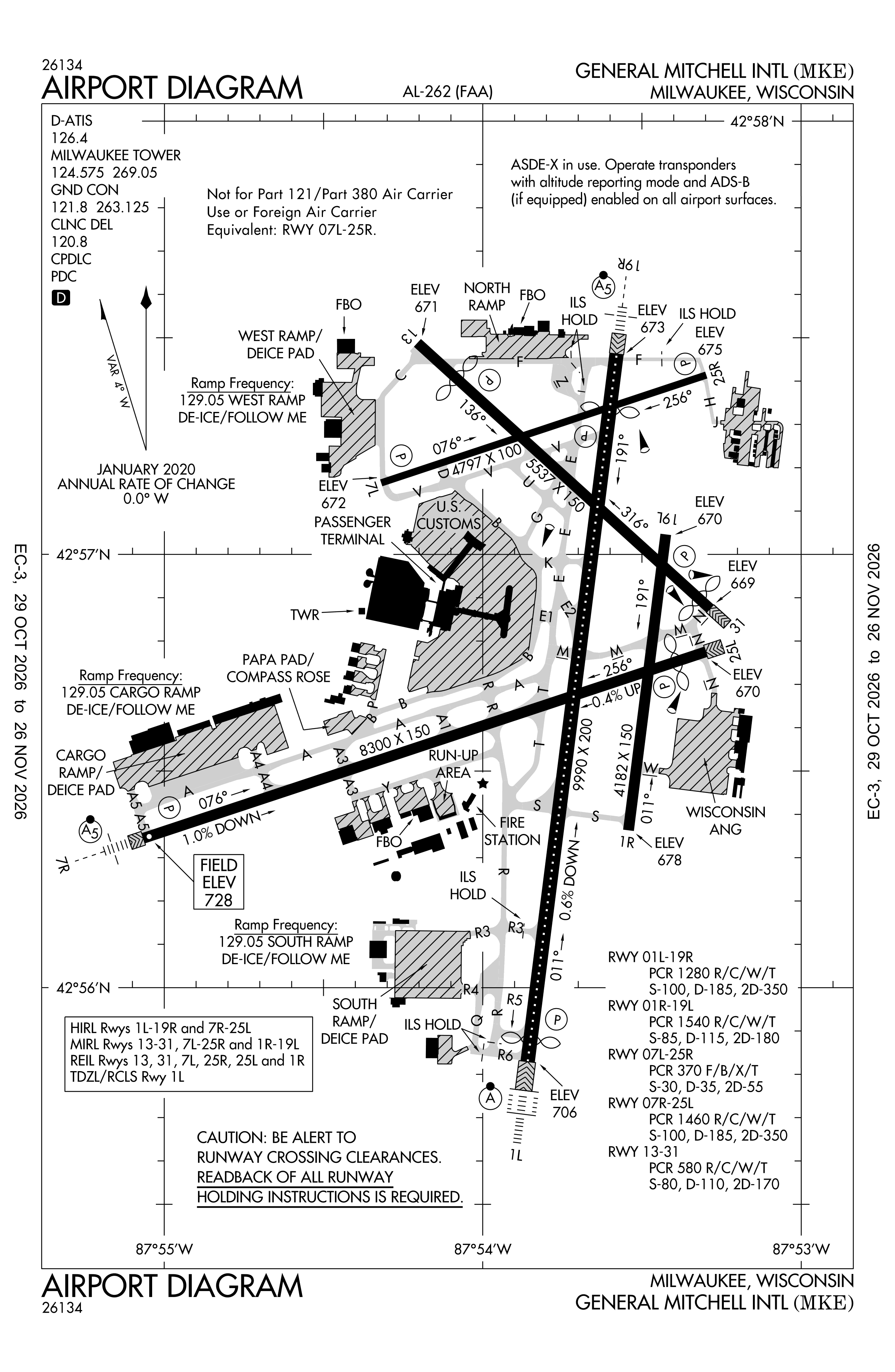
Redrawn by cwsi.net from the FAA airport diagram, cycle 2611, effective Oct 29 to Nov 26, 2026, and OpenStreetMap. Reference only, not for navigation.
FBOs and services
FBOs
 Signature Milwaukee923 East Layton Avenue, Milwaukee, WI 53207+1 414-747-5100Hours: 24 hours a day/7 days a weekSignature page
- Avflight+1 414-800-1590avflight.comHours: Mo-Su 04:00-22:00
- Jet Aviation+1 414-348-5900jetaviation.comHours: Mo-Su 05:00-21:00
- Landmark Aviation
FBO details may be out of date. Call ahead to confirm services and hours.
Not listed? Send a correction.
As of Nov 3, 2026.
Related
- Interactive NOTAM search for KMKE (category filters, maps, share links and a NOTAM decoder)
- Milwaukee Mitchell International Airport: codes, map and current weather
- MKE weather and runway winds (METAR and TAF in plain English)
- Airport lounges at MKE by terminal
- Flights at MKE now
- NOTAMs for other US airports
More NOTAMs in Wisconsin
Times are UTC (Z). Plain-English explanations are generated by cwsi.net from the NOTAM abbreviations and may simplify; the original NOTAM text is authoritative. NOTAMs come from the FAA NOTAM Management Service; cwsi.net refreshes its copy every 3 minutes. cwsi.net is not affiliated with the FAA: always confirm NOTAMs through official sources (a standard briefing or FAA NOTAM Search) before flight.