IMT NOTAMs
Ford Airport, Iron Mountain, MI · KIMT
Ford Airport in Iron Mountain, Michigan (IATA IMT, ICAO KIMT) has 15 current NOTAMs (Notices to Air Missions): 14 in effect now and 1 starting later. By category: runways (7), aprons (2) and obstacles (2). The list comes from the FAA NOTAM Management Service, refreshed by cwsi.net every few minutes; each NOTAM shows its number, category, start and end time in UTC, and a plain-English reading.
- Runway7
- Apron2
- Obstacle2
- Taxiway2
- Navaid1
- Procedures1
In effect now (14)
RWY 31 FICON 5/5/5 100 PCT WET OBS AT 2611051209. 2611051209-2611052200
TWY ALL FICON WET OBS AT 2611051209. 2611051209-2611052200
RWY 01 FICON 5/5/5 100 PCT WET OBS AT 2611051208. 2611051208-2611052200
APRON ALL FICON WET OBS AT 2611051208. 2611051208-2611052200
RWY 31 FICON 5/5/5 100 PCT WET OBS AT 2611050201. COND NOT MNT 2611050300-2611051400. 2611050201-2611051400
TWY ALL FICON WET OBS AT 2611050201. COND NOT MNT 2611050300-2611051400. 2611050201-2611051400
APRON ALL FICON WET OBS AT 2611050200. COND NOT MNT 2611050300-2611051400. 2611050200-2611051400
RWY 01 FICON 5/5/5 100 PCT WET OBS AT 2611050159. COND NOT MNT 2611050300-2611051400. 2611050159-2611051400
OBST TOWER LGT (ASR 1005819) 454914.00N0880233.40W (3.0NM E IMT) 1839.9FT (273.0FT AGL) U/S 2610301738-2611141638
ODP FORD, IRON MOUNTAIN KINGSFORD, MI. TAKEOFF MINIMUMS AND (OBSTACLE) DEPARTURE PROCEDURES AMDT 6... TAKE-OFF MINIMUMS RWY 19: 300-1 3/8 OR STANDARD WITH MINIMUM CLIMB OF 210 FT/NM TO 1400, OR ALTERNATIVELY, WITH STANDARD TAKEOFF MINIMUMS AND A NORMAL 200 FT/NM CLIMB GRADIENT, TAKEOFF MUST OCCUR NO LATER THAN 1400 FEET PRIOR TO DER. TAKE-OFF MINIMUMS RWY 13: 300-1 1/8 OR STANDARD WITH MINIMUM CLIMB OF 636 FT/NM TO 1400. TAKE-OFF MINIMUMS RWY 31: 300-1 5/8 OR STANDARD WITH MINIMUM CLIMB OF 286 FT/NM TO 1400. ALL OTHER DATA REMAINS AS PUBLISHED. 2607021121-2807021121EST
OBST BLDG (ASN 2020-AGL-22506-OE) 455007N0880518W (1.5NM NE IMT) 1631FT (176FT AGL) NOT LGTD 2606301206-2706302300
RWY 31 RWY END ID LGT U/S 2606301204-2706302300
RWY 01/19 SAFETY AREA NOT STD SW SIDE BETWEEN TWY C & RWY 13/31 2606301202-2706302200
NAV DME 1061.0 MHZ/CH100Y COMMISSIONED 2509111925-PERM
Starting later (1)
RWY 31 PAPI U/S 2611061330-2611061800
Airport diagram
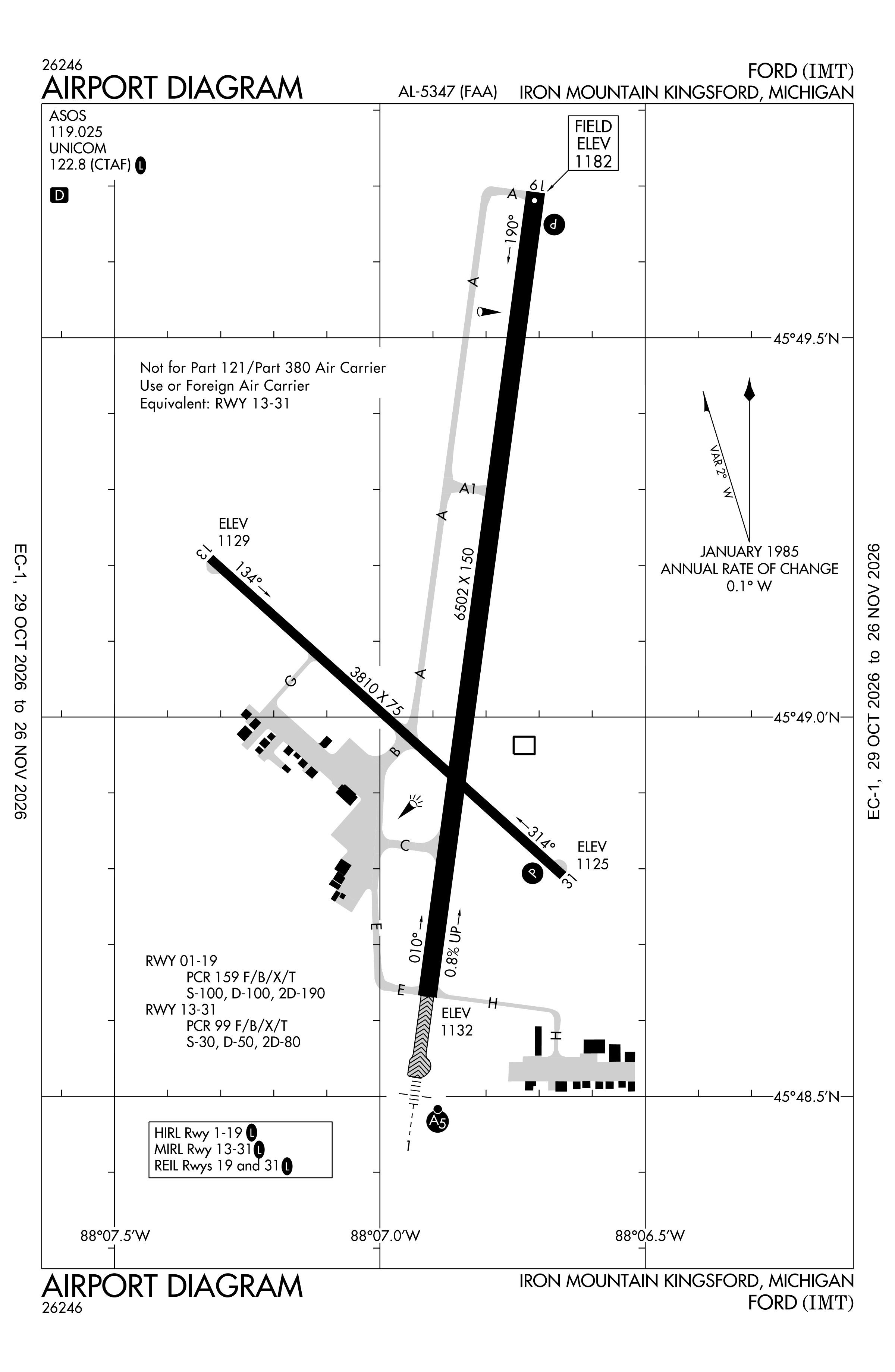
Official FAA PDF (effective Oct 29 to Nov 26)
FAA airport diagram, cycle 2611, effective Oct 29 to Nov 26, 2026. Reference only, not for navigation.
FBOs and services
FBOs
No FBOs are listed in OpenStreetMap for this airport.
Not listed? The FBO may not be in OpenStreetMap. Send a correction.
Data © OpenStreetMap contributors (ODbL), as of Nov 3, 2026.
Related
- Interactive NOTAM search for KIMT (category filters, maps, share links and a NOTAM decoder)
- Ford Airport: codes, map and current weather
- IMT weather and runway winds (METAR and TAF in plain English)
- Flights at IMT now
- NOTAMs for other US airports
More NOTAMs in Michigan
Times are UTC (Z). Plain-English explanations are generated by cwsi.net from the NOTAM abbreviations and may simplify; the original NOTAM text is authoritative. NOTAMs come from the FAA NOTAM Management Service; cwsi.net refreshes its copy every 3 minutes. cwsi.net is not affiliated with the FAA: always confirm NOTAMs through official sources (a standard briefing or FAA NOTAM Search) before flight.