HOB NOTAMs
Lea County Regional Airport, Hobbs, NM · KHOB
Lea County Regional Airport in Hobbs, New Mexico (IATA HOB, ICAO KHOB) has 22 current NOTAMs (Notices to Air Missions): 22 in effect now and 0 starting later. By category: obstacles (6), taxiways (6) and runways (5). The list comes from the FAA NOTAM Management Service, refreshed by cwsi.net every few minutes; each NOTAM shows its number, category, start and end time in UTC, and a plain-English reading.
- Obstacle6
- Taxiway6
- Runway5
- Navaid2
- Procedures2
- Airspace1
In effect now (22)
NAV ILS RWY 04 U/S 2611022318-2611132359EST
TWY D BTN TWY E AND RWY 17/35 CLSD 2611041400-2611060001EST
OBST TOWER LGT (ASR 1002982) 323116.80N1033137.90W (18.6NM WSW HOB) 4140.7FT (338.9FT AGL) U/S 2611020551-2611170451
TWY D WIP CONSTRUCTION TRAFFIC AT RWY 13/31 INTERSECTION MON-FRI 1300-0001 2611021300-2612040001EST
OBST TOWER LGT (ASR 1053915) 324343.00N1025619.00W (14.4NM E HOB) 4068.9FT (559.1FT AGL) U/S 2610281719-2611062359
OBST TOWER LGT (ASR 1051482) 324142.80N1032210.90W (7.7NM W HOB) 4289.0FT (474.1FT AGL) U/S 2610211646-2701191746
OBST TOWER LGT (ASR 1006044) 324049.20N1030901.80W (3.4NM E HOB) 4120.7FT (514.8FT AGL) U/S 2610201814-2702171813
AIRSPACE UAS WI AN AREA DEFINED AS .5NM RADIUS OF 323233N1033140W (17.7NM SW HOB) SFC-400FT AGL 2610121800-2701122359
IAP LEA COUNTY RGNL, HOBBS, NM. VOR OR TACAN RWY 22, AMDT 10... TACAN PORTION NA, HOB TACAN AZIMUTH OUT OF SERVICE. 2610021608-2705141608EST
OBST TOWER LGT (ASR 1055403) 323129.00N1033148.00W (18.6NM WSW HOB) 4245.4FT (442.9FT AGL) U/S 2609172351-2612162359
RWY 13 PAPI U/S 2608271100-2612302100
RWY 31 PAPI U/S 2608271100-2612302100
TWY D1 CLSD 2608252002-2611302359EST
TWY B1, TWY B BTN RWY 04/22 AND APCH END RWY 31 CLSD 2608251300-2612312359EST
TWY F CLSD 2608251300-2611302359EST
TWY E BTN APCH END RWY 17 AND TWY F CLSD 2608251300-2611302359EST
RWY 13/31 CLSD 2608251300-2612312359EST
RWY 17/35 CLSD 2608251300-2611302359EST
OBST TOWER LGT (ASR 1032566) 323400.25N1034336.76W (26.8NM SW HOB) 3933FT (396FT AGL) U/S 2608151751-2611132359
NAV TACAN AZM U/S 2607131905-2701062300EST
RWY 22 DECLARED DIST: TORA 8000FT TODA 8000FT ASDA 8000FT LDA 7398FT. 2607010429-2702271200EST
IAP LEA COUNTY RGNL, HOBBS, NM. ILS OR LOC RWY 4, AMDT 9... DME REQUIRED. 2602131821-2802131821EST
Airport diagram
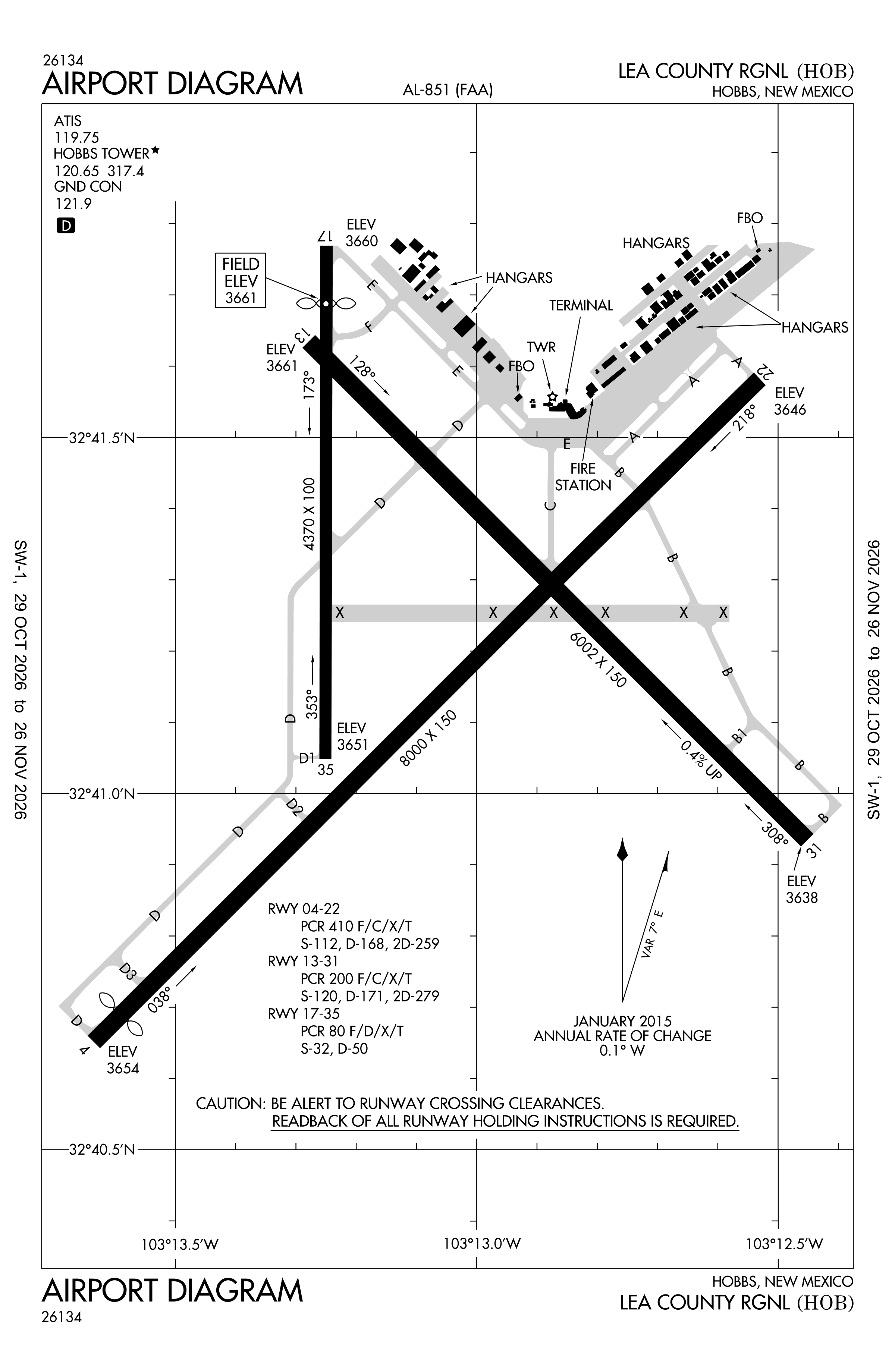
Official FAA PDF (effective Oct 29 to Nov 26)
FAA airport diagram, cycle 2611, effective Oct 29 to Nov 26, 2026. Reference only, not for navigation.
FBOs and services
FBOs
No FBOs are listed in OpenStreetMap for this airport.
Not listed? The FBO may not be in OpenStreetMap. Send a correction.
Data © OpenStreetMap contributors (ODbL), as of Nov 3, 2026.
Related
- Interactive NOTAM search for KHOB (category filters, maps, share links and a NOTAM decoder)
- Lea County Regional Airport: codes, map and current weather
- HOB weather and runway winds (METAR and TAF in plain English)
- Flights at HOB now
- NOTAMs for other US airports
More NOTAMs in New Mexico
Times are UTC (Z). Plain-English explanations are generated by cwsi.net from the NOTAM abbreviations and may simplify; the original NOTAM text is authoritative. NOTAMs come from the FAA NOTAM Management Service; cwsi.net refreshes its copy every 3 minutes. cwsi.net is not affiliated with the FAA: always confirm NOTAMs through official sources (a standard briefing or FAA NOTAM Search) before flight.