FSD NOTAMs
Sioux Falls Regional Airport, Sioux Falls, SD · KFSD
Sioux Falls Regional Airport in Sioux Falls, South Dakota (IATA FSD, ICAO KFSD) has 14 current NOTAMs (Notices to Air Missions): 14 in effect now and 0 starting later. By category: obstacles (3), procedures (3) and runways (3). The list comes from the FAA NOTAM Management Service, refreshed by cwsi.net every few minutes; each NOTAM shows its number, category, start and end time in UTC, and a plain-English reading.
- Obstacle3
- Procedures3
- Runway3
- Navaid2
- Aerodrome1
- Airspace1
- Apron1
In effect now (14)
OBST TOWER LGT (ASR 1042075) 432920.00N0963819.00W (7.2NM SE FSD) 1634.8FT (224.1FT AGL) U/S 2611031558-2702032359
OBST TOWER LGT (ASR 1042072) 432915.00N0963814.00W (7.3NM SE FSD) 1634.8FT (224.1FT AGL) U/S 2611031557-2702032359
AD AP BIRD ACT INCREASED 2611021401-2612312300
RWY 15/33 SAFETY AREA NOT STD SFC VARIATIONS 2609291323-2701052330
RWY 03/21 SAFETY AREA NOT STD SFC VARIATIONS 2609291323-2701052330
RWY 09/27 SAFETY AREA NOT STD SFC VARIATIONS 2609291323-2701052330
APRON HELIPAD H1 CLSD 2609242126-2612042330
OBST CRANE (ASN 2026-AGL-3624-OE) 433707N0964701W (2.8NM NW FSD) 1675FT (140FT AGL) FLAGGED AND LGTD 2608241200-2611202300
AIRSPACE UAS WI AN AREA DEFINED AS 434422.20N0963753.40W (10.6NM NNE FSD) TO 434422.20N0963641.40W (11.0NM NNE FSD) TO 434355.80N0963641.40W (10.6NM NNE FSD) TO 434355.80N0963753.40W (10.2NM NNE FSD) TO POINT OF ORIGIN SFC-699FT AGL MON-FRI SR-SS 2607201103-2612312259
NAV ILS RWY 03 OM U/S 2603052005-2709302111EST
NAV ILS RWY 21 OM U/S 2603051956-2709302111EST
IAP JOE FOSS FLD, SIOUX FALLS, SD. RNAV (GPS) RWY 15, AMDT 1B... RNAV (GPS) RWY 27, ORIG-F... RNAV (GPS) RWY 33, AMDT 2A... VOR OR TACAN RWY 15, AMDT 21F... VOR/DME OR TACAN RWY 33, AMDT 12F... CIRCLING CAT A MDA 1980/HAA 550. 2510301647-2710301647EST
IAP JOE FOSS FLD, SIOUX FALLS, SD. RNAV (GPS) RWY 15, AMDT 1B... LPV DA 1851/HAT 422, VIS 1 1/4. LNAV/VNAV DA 1929/HAT 500. 2510141639-2710141639EST
IAP JOE FOSS FLD, SIOUX FALLS, SD. VOR OR TACAN RWY 15, AMDT 21F... S-15 MDA 1960/HAT 531 ALL CATS, VIS CAT C/D/E 1 1/2. 2506231725-2706231725EST
Airport diagram

FAA chart (PNG) Official FAA PDF (effective Oct 29 to Nov 26)
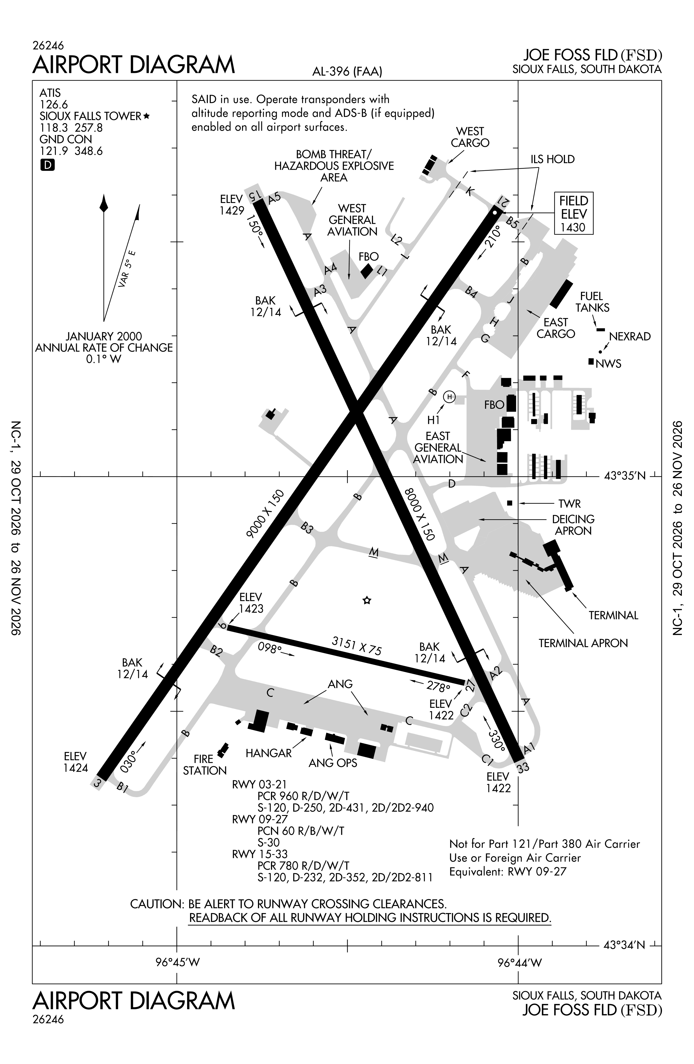
Redrawn by cwsi.net from the FAA airport diagram, cycle 2611, effective Oct 29 to Nov 26, 2026, and OpenStreetMap. Reference only, not for navigation.
FBOs and services
FBOs
 Signature Sioux Falls3501 Aviation Avenue, Sioux Falls, SD 57104+1 605-336-7791Hours: 0500L - 2200LUNICOM 122.95Signature page
FBO details may be out of date. Call ahead to confirm services and hours.
Not listed? Send a correction.
As of Nov 5, 2026.
Related
- Interactive NOTAM search for KFSD (category filters, maps, share links and a NOTAM decoder)
- Sioux Falls Regional Airport: codes, map and current weather
- FSD weather and runway winds (METAR and TAF in plain English)
- Flights at FSD now
- NOTAMs for other US airports
More NOTAMs in South Dakota
Times are UTC (Z). Plain-English explanations are generated by cwsi.net from the NOTAM abbreviations and may simplify; the original NOTAM text is authoritative. NOTAMs come from the FAA NOTAM Management Service; cwsi.net refreshes its copy every 3 minutes. cwsi.net is not affiliated with the FAA: always confirm NOTAMs through official sources (a standard briefing or FAA NOTAM Search) before flight.