ABR NOTAMs
Aberdeen Regional Airport, Aberdeen, SD · KABR
Aberdeen Regional Airport in Aberdeen, South Dakota (IATA ABR, ICAO KABR) has 20 current NOTAMs (Notices to Air Missions): 18 in effect now and 2 starting later. By category: runways (6), communications (3) and procedures (3). The list comes from the FAA NOTAM Management Service, refreshed by cwsi.net every few minutes; each NOTAM shows its number, category, start and end time in UTC, and a plain-English reading.
- Runway6
- Communications3
- Procedures3
- Apron2
- Obstacle2
- Taxiway2
- Aerodrome1
- Navaid1
In effect now (18)
RWY 31 FICON 5/5/5 40 PCT WET OBS AT 2611041756. 2611041756-2611051756
TWY ALL FICON PATCHY WET OBS AT 2611041756. 2611041756-2611051756
APRON ALL FICON PATCHY WET OBS AT 2611041756. 2611041756-2611051756
RWY 35 FICON 5/5/5 40 PCT WET OBS AT 2611041755. 2611041755-2611051755
RWY 35 FICON 5/5/5 100 PCT WET OBS AT 2611041754. 2611041754-2611051754
APRON ALL FICON WET OBS AT 2611041456. 2611041456-2611051456
TWY ALL FICON WET OBS AT 2611041457. 2611041457-2611051457
RWY 35 FICON 5/5/5 100 PCT WET OBS AT 2611041456. 2611041456-2611051456
RWY 31 FICON 5/5/5 100 PCT WET OBS AT 2611041455. 2611041455-2611051455
COM VOR VOICE 122.1 U/S 2611032037-2705032111EST
AD AP BIRD ACT INCREASED MIGRATORY BIRDS 2611031649-2611302100
RWY 13 RWY END ID LGT U/S 2611031229-2611172359
OBST TOWER LGT (ASR 1041643) 452757.00N0982013.00W (3.8NM ENE ABR) 1711.9FT (412.1FT AGL) U/S 2610191615-2701182359
OBST TOWER LGT (ASR 1037199) 451945.00N0982200.00W (7.4NM S ABR) 1539FT (240FT AGL) U/S 2610180725-2612020725
NAV ILS RWY 31 OM U/S 2608161330-2801282000EST
IAP ABERDEEN RGNL, ABERDEEN, SD. RNAV (GPS) RWY 13, AMDT 1B... RNAV (GPS) RWY 31, ORIG-D... RNAV (GPS) RWY 35, AMDT 1B... VOR RWY 31, AMDT 21C... CIRCLING CAT A/B HAA 598/MDA 1900. TEMPORARY CRANE, 1538 MSL, 1.3 NM NNE OF RWY 17 (2025-AGL-14613-OE). 2607091052-2702180231EST
ODP ABERDEEN RGNL, ABERDEEN, SD. TAKEOFF MINIMUMS AND (OBSTACLE) DEPARTURE PROCEDURES AMDT 1... TAKE-OFF MINIMUMS: RWY 35, 300-1 1/2, OR STD WITH A MINIMUM CLIMB OF 310 FEET PER NM TO 1700. TEMPORARY CRANE, 1.2 NM FROM DER, 973 FT RIGHT OF CENTERLINE, 238 FT AGL/1538 FT MSL (2025-AGL-14613-OE). ALL OTHER DATA REMAINS AS PUBLISHED. 2607091052-2702180231EST
IAP ABERDEEN RGNL, ABERDEEN, SD. RNAV (GPS) RWY 17, ORIG-A... LNAV/VNAV ALL CATS DA1840/HAT 538, VISIBILITY 1 1/2. LNAV ALL CATS MDA 1840/HAT 538; VISIBILITY CAT C/D 1 1/2. CIRCLING CAT A/B MDA 1900/HAA 598. TEMPORARY CRANE, 1538 MSL, 1.3 NM NNE OF RWY 17 (2025-AGL-14613-OE. 2607091052-2702180231EST
Starting later (2)
COM REMOTE COM OUTLET 122.1 NOT AVBL 2611060500-2611061230
COM REMOTE COM OUTLET 121.5 NOT AVBL 2611060500-2611061230
Airport diagram
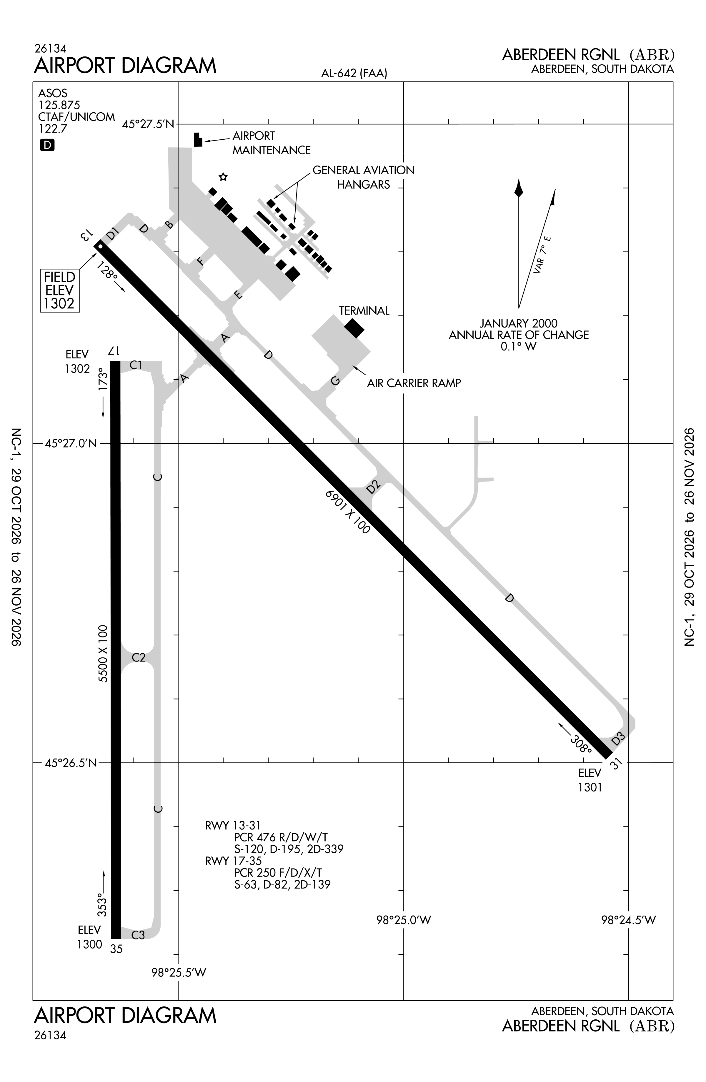
Official FAA PDF (effective Oct 29 to Nov 26)
FAA airport diagram, cycle 2611, effective Oct 29 to Nov 26, 2026. Reference only, not for navigation.
FBOs and services
FBOs
No FBOs are listed in OpenStreetMap for this airport.
Not listed? The FBO may not be in OpenStreetMap. Send a correction.
Data © OpenStreetMap contributors (ODbL), as of Nov 3, 2026.
Related
- Interactive NOTAM search for KABR (category filters, maps, share links and a NOTAM decoder)
- Aberdeen Regional Airport: codes, map and current weather
- ABR weather and runway winds (METAR and TAF in plain English)
- Flights at ABR now
- NOTAMs for other US airports
More NOTAMs in South Dakota
Times are UTC (Z). Plain-English explanations are generated by cwsi.net from the NOTAM abbreviations and may simplify; the original NOTAM text is authoritative. NOTAMs come from the FAA NOTAM Management Service; cwsi.net refreshes its copy every 3 minutes. cwsi.net is not affiliated with the FAA: always confirm NOTAMs through official sources (a standard briefing or FAA NOTAM Search) before flight.