TTN NOTAMs
Trenton Mercer Airport, Trenton, NJ · KTTN
Trenton Mercer Airport in Trenton, New Jersey (IATA TTN, ICAO KTTN) has 21 current NOTAMs (Notices to Air Missions): 16 in effect now and 5 starting later. By category: obstacles (12), procedures (3) and runways (3). The list comes from the FAA NOTAM Management Service, refreshed by cwsi.net every few minutes; each NOTAM shows its number, category, start and end time in UTC, and a plain-English reading.
- Obstacle12
- Procedures3
- Runway3
- Taxiway2
- Navaid1
In effect now (16)
OBST TOWER LGT (ASN UNKNOWN) 401631N0744832W (0.15NM N APCH END RWY 34) UNKNOWN (15FT AGL) U/S 2611011122-2611302100
OBST TOWER LGT (ASR 1045252) 401409.20N0744612.10W (3.2NM SE TTN) 367FT (253FT AGL) U/S 2610240531-2612080531
NAV ILS RWY 06 U/S 2610061333-2611102359
IAP TRENTON MERCER, TRENTON, NJ. RNAV (GPS) Z RWY 6, ORIG-E... LPV DA 440/HAT 254 ALL CATS. WHEN LOCAL ALTIMETER SETTING NOT RECEIVED, USE NORTHEAST PHILADELPHIA ALTIMETER SETTING AND INCREASE LPV DA TO 487 FEET; INCREASE LNAV/VNAV DA TO 658 FEET AND ALL VISIBILITIES 1/4 SM; INCREASE ALL MDAS 60 FEET AND LNAV VISIBILITY CATS C/D TO 1 3/8. TEMPORARY CRANE 358FT MSL 2782FT EAST OF RWY 6 (2021-AEA-1167-NRA). 2609221401-2703231401EST
OBST TOWER LGT (ASR 1034808) 401519.00N0745143.00W (2.6NM WSW TTN) 429.8FT (249.3FT AGL) U/S 2609011236-2611301336
OBST TOWER LGT (ASR 1044426) 401405.00N0744600.60W (3.3NM SE TTN) 569.9FT (457.0FT AGL) U/S 2608231525-2611220400
IAP TRENTON MERCER, TRENTON, NJ. RNAV (GPS) RWY 34, ORIG-E... DISREGARD NOTE: (DO NOT EXCEED 250K UNTIL ZUBAX) IN MISSED APPROACH DESCRIPTION.. 2608201540-2808201540EST
IAP TRENTON MERCER, TRENTON, NJ. ILS OR LOC RWY 6, AMDT 11... S-ILS 6 DA 440/HAT 254 ALL CATS. FOR INOPERATIVE ALS INCREASE S-ILS 6 VISIBILITY TO 7/8. INCREASE S-LOC 6 CAT C/D VISIBILITY TO 1 3/8. TEMPORARY CRANE 358FT MSL 2782FT NORTHEAST OF RWY 6 (2021-AEA-1167-NRA). 2608111619-2703231615EST
OBST CRANE (ASN 2026-AEA-1318-NRA) 401702N0744823W (0.5NM NE TTN) 350FT (150FT AGL) FLAGGED AND LGTD 2608101100-2703312200
OBST CRANE (ASN 2026-AEA-1423-NRA) 401701N0744824W (0.5NM NE TTN) 350FT (150FT AGL) FLAGGED AND LGTD 2608101100-2703312200
OBST CRANE (ASN 2026-AEA-1317-NRA) 401701N0744823W (0.5NM NE TTN) 350FT (150FT AGL) FLAGGED AND LGTD 2608101100-2703312200
OBST CRANE (ASN 2026-AEA-1315-NRA) 401701N0744824W (0.5NM NE TTN) 350FT (150FT AGL) FLAGGED AND LGTD 2608101100-2703312200
OBST TOWER LGT (ASR 1049865) 401717.00N0745224.00W (2.8NM WNW TTN) 362.2FT (303.1FT AGL) U/S 2607062120-2611072359
OBST TOWER LGT (ASR 1049866) 401716.00N0745222.00W (2.8NM WNW TTN) 362.2FT (303.1FT AGL) U/S 2607062120-2611072359
OBST TOWER LGT (ASR 1049864) 401718.00N0745218.00W (2.7NM WNW TTN) 362.2FT (303.1FT AGL) U/S 2607062119-2611072359
OBST TOWER LGT (ASR 1049863) 401719.00N0745220.00W (2.7NM WNW TTN) 362.2FT (303.1FT AGL) U/S 2607062118-2611072359
Starting later (5)
TWY B BTN JOHNSON AND JOHNSON RAMP AND APCH END RWY 24 CLSD DLY 0300-1100 2611080300-2611101100
TWY J CLSD DLY 0300-1100 2611080300-2611101100
RWY 06/24 CLSD EXC XNG 2611101300-2611101900
RWY 06/24 CLSD EXC AIR CARRIERS DLY 0300-1100 2611080300-2611091100
RWY 06/24 CLSD EXC AIR CARRIERS 2611080300-2611081100
Airport diagram
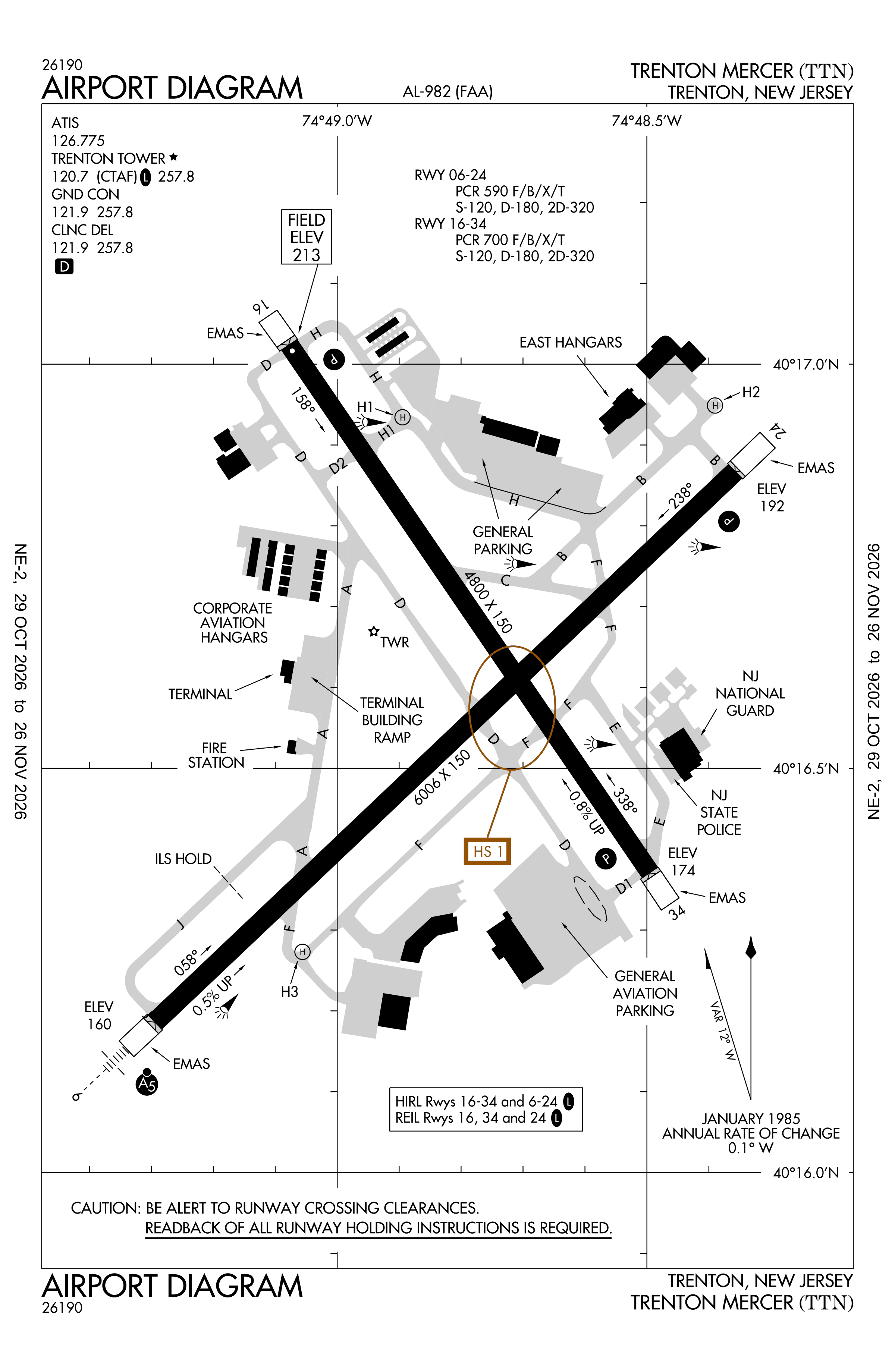
Official FAA PDF (effective Oct 29 to Nov 26)
FAA airport diagram, cycle 2611, effective Oct 29 to Nov 26, 2026. Reference only, not for navigation.
FBOs and services
FBOs
 Signature Trenton18 West Piper Avenue, Trenton, NJ 08628+1 609-771-9500Hours: 24 hours a day/7 days a weekARINC 130.225Signature pageSource: Signature Aviation
FBO locations from the operators' own sites, may be out of date. Call ahead to confirm services and hours.
Not listed? The FBO may not be in OpenStreetMap. Send a correction.
Signature Aviation locations, as of Nov 5, 2026.
Related
- Interactive NOTAM search for KTTN (category filters, maps, share links and a NOTAM decoder)
- Trenton Mercer Airport: codes, map and current weather
- TTN weather and runway winds (METAR and TAF in plain English)
- Flights at TTN now
- NOTAMs for other US airports
More NOTAMs in New Jersey
Times are UTC (Z). Plain-English explanations are generated by cwsi.net from the NOTAM abbreviations and may simplify; the original NOTAM text is authoritative. NOTAMs come from the FAA NOTAM Management Service; cwsi.net refreshes its copy every 3 minutes. cwsi.net is not affiliated with the FAA: always confirm NOTAMs through official sources (a standard briefing or FAA NOTAM Search) before flight.