SUX NOTAMs
Sioux Gateway Airport, Sioux City, IA · KSUX
Sioux Gateway Airport in Sioux City, Iowa (IATA SUX, ICAO KSUX) has 34 current NOTAMs (Notices to Air Missions): 31 in effect now and 3 starting later. By category: runways (10), taxiways (7) and aprons (6). The list comes from the FAA NOTAM Management Service, refreshed by cwsi.net every few minutes; each NOTAM shows its number, category, start and end time in UTC, and a plain-English reading.
- Runway10
- Taxiway7
- Apron6
- Obstacle5
- Navaid3
- Procedures2
- Aerodrome1
In effect now (31)
APRON ALL FICON WET OBS AT 2611051109. 2611051109-2611061109
APRON ALL FICON PATCHY WET OBS AT 2611051109. 2611051109-2611061109
TWY ALL FICON PATCHY WET OBS AT 2611051108. 2611051108-2611061108
TWY ALL FICON WET OBS AT 2611050243. 2611050243-2611060243
APRON ALL FICON WET OBS AT 2611050243. 2611050243-2611060243
RWY 31 FICON 5/5/5 100 PCT WET OBS AT 2611050242. 2611050242-2611060242
RWY 36 FICON 5/5/5 100 PCT WET OBS AT 2611050242. 2611050242-2611060242
TWY ALL FICON WET OBS AT 2611042057. 2611042057-2611052057
APRON ALL FICON WET OBS AT 2611042057. 2611042057-2611052057
RWY 31 FICON 5/5/5 100 PCT WET OBS AT 2611042056. 2611042057-2611052057
RWY 36 FICON 5/5/5 100 PCT WET OBS AT 2611042056. 2611042056-2611052056
TWY ALL FICON PATCHY WET OBS AT 2611041850. 2611041850-2611051850
RWY 36 FICON 20 PCT WET OBS AT 2611041849. 2611041849-2611051849
APRON ALL FICON PATCHY WET OBS AT 2611041850. 2611041850-2611051850
RWY 31 FICON 25 PCT WET OBS AT 2611041849. 2611041849-2611051849
APRON ALL FICON WET OBS AT 2611041347. 2611041347-2611051347
RWY 36 FICON 5/5/5 100 PCT WET OBS AT 2611041346. 2611041346-2611051346
TWY ALL FICON WET OBS AT 2611041346. 2611041346-2611051346
RWY 31 FICON 5/5/5 100 PCT WET OBS AT 2611041345. 2611041345-2611051345
AD BIRD ACTIVITY PHASE II IN EFFECT BASH PHASE II OPR IN EFF 1 NOV 15 DEC. BIRD WATCH COND ARE NOT RPTD ON ATIS. CTC AFLD MGMT OR CMND POST FOR CURRENT BWC. REAL-TIME BWC CAN ONLY BE DETERMINED WHEN THE FLD COND ARE AT LEAST 3000' AND 5 STATUTE MILES. 2611031242-2612152359
RWY 18 TWY DIRECTION SIGN AT TWY E LGT U/S 2611030508-2611062300
OBST TOWER LGT (ASR 1259762) 422826.40N0960940.50W (10.8NM ENE SUX) 1599.1FT (253.9FT AGL) U/S 2610291049-2611130949
OBST TOWER LGT (ASR 1051813) 423053.00N0961816.00W (7.7NM NNE SUX) 2395.0FT (973.1FT AGL) U/S 2610261554-2611262359
IAP SIOUX GATEWAY/BRIG GENERAL BUD DAY FLD, SIOUX CITY, IA. RNAV (GPS) RWY 18, AMDT 2... LNAV/VNAV DA 1517/HAT 419 ALL CATS. TOWER, 1233 MSL, 1.21 NM NORTH OF RWY 18 (19-070707). 2610091512-2810091512EST
OBST CRANE (ASN 2026-ACE-889-OE) 422601N0962351W (2.0NM NNW SUX) 1225FT (130FT AGL) FLAGGED 2609281924-2703312300
TWY A BTN TWY B AND ARFF RAMP NORTH ACCESS CLSD EXC ACFT WINGSPAN LESS THAN 118FT 2609211218-2611302300
OBST BATCH PLANT (ASN 2026-ACE-3151-NRA) 422438N0962328W (0.6NM NNW SUX) 1188FT (100FT AGL) LGTD 2609111847-2612222300
IAP SIOUX GATEWAY/BRIG GENERAL BUD DAY FLD, SIOUX CITY, IA. ILS OR LOC RWY 13, AMDT 3B... AUTOPILOT COUPLED APPROACH NA BELOW 2140FT MSL. 2608251948-2808241948EST
TWY A BTN TWY A RUNUP PAD FOR RWY 13 AND TWY F CLSD 2608101200-2611302300
RWY 13 VASI U/S 2606292338-2812292000EST
NAV ILS RWY 13 OM U/S 2605202315-2612182111EST
Starting later (3)
OBST CRANE (ASN 2026-ACE-2322-OE) 422548N0962512W (2.3NM NW SUX) 1308FT (206FT AGL) FLAGGED 2611051330-2611062330
NAV ILS RWY 13 LOC/GP NOT MNT 2611060600-2611061200
NAV ILS RWY 31 LOC/GP NOT MNT 2611060600-2611061200
Airport diagram
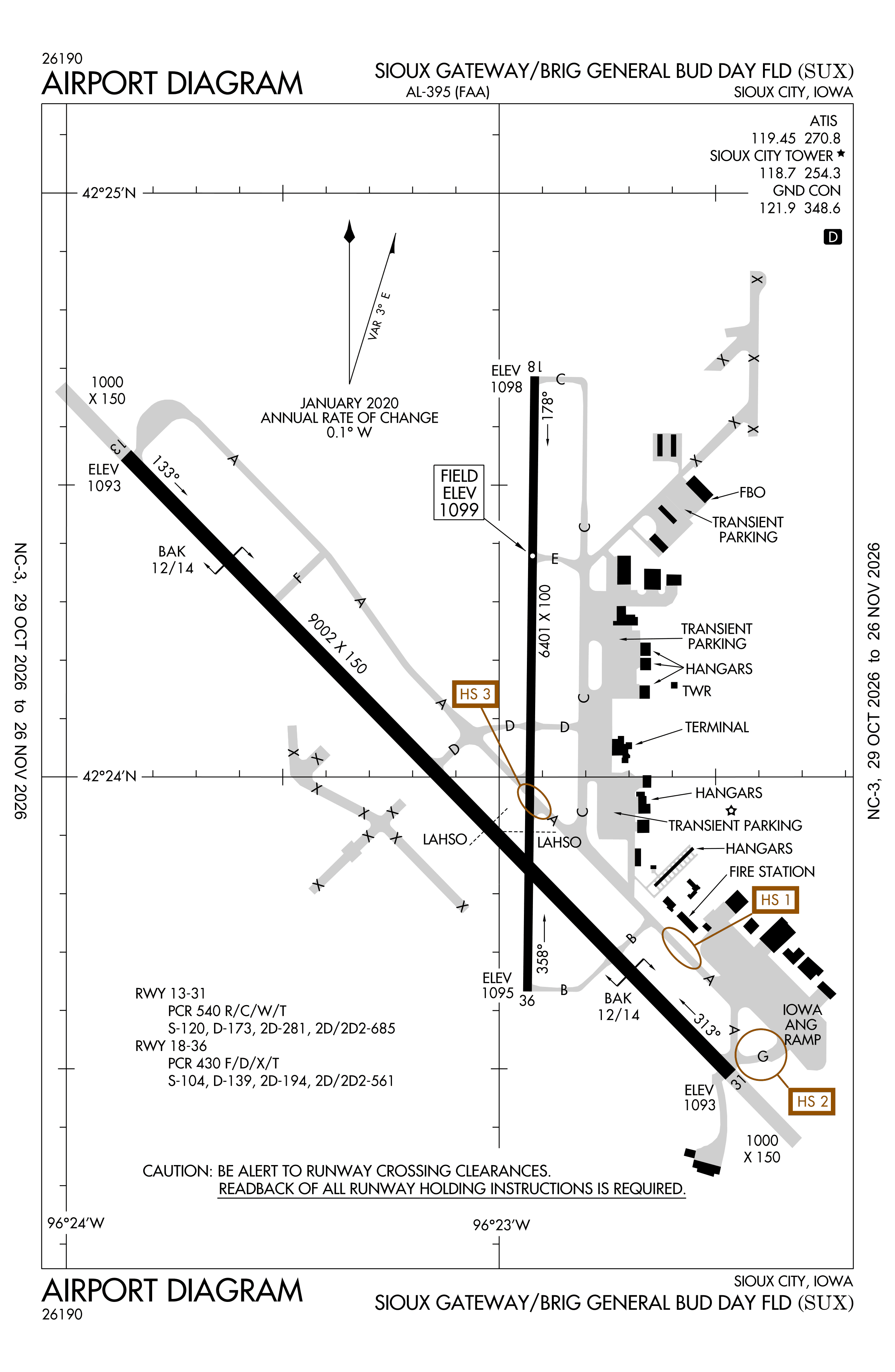
Official FAA PDF (effective Oct 29 to Nov 26)
FAA airport diagram, cycle 2611, effective Oct 29 to Nov 26, 2026. Reference only, not for navigation.
FBOs and services
FBOs
No FBOs are listed in OpenStreetMap for this airport.
Not listed? The FBO may not be in OpenStreetMap. Send a correction.
Data © OpenStreetMap contributors (ODbL), as of Nov 3, 2026.
Related
- Interactive NOTAM search for KSUX (category filters, maps, share links and a NOTAM decoder)
- Sioux Gateway Airport: codes, map and current weather
- SUX weather and runway winds (METAR and TAF in plain English)
- Flights at SUX now
- NOTAMs for other US airports
More NOTAMs in Iowa
Times are UTC (Z). Plain-English explanations are generated by cwsi.net from the NOTAM abbreviations and may simplify; the original NOTAM text is authoritative. NOTAMs come from the FAA NOTAM Management Service; cwsi.net refreshes its copy every 3 minutes. cwsi.net is not affiliated with the FAA: always confirm NOTAMs through official sources (a standard briefing or FAA NOTAM Search) before flight.