SGF NOTAMs
Springfield-Branson National Airport, Springfield, MO · KSGF
Springfield-Branson National Airport in Springfield, Missouri (IATA SGF, ICAO KSGF) has 12 current NOTAMs (Notices to Air Missions): 6 in effect now and 6 starting later. By category: obstacles (3), airspace (2) and procedures (2). The list comes from the FAA NOTAM Management Service, refreshed by cwsi.net every few minutes; each NOTAM shows its number, category, start and end time in UTC, and a plain-English reading.
- Obstacle3
- Airspace2
- Procedures2
- Runway2
- Services2
- Navaid1
In effect now (6)
OBST TOWER LGT (ASR 1287276) 371113.00N0933259.50W (8.5NM WSW SGF) 1498.7FT (259.8FT AGL) U/S 2611161221-2702140500
OBST TOWER LGT (ASR 1247437) 371510.50N0932601.70W (2.2NM W SGF) 1512.1FT (265.1FT AGL) U/S 2611110531-2611260431
AIRSPACE UAS WI AN AREA DEFINED AS 1NM RADIUS OF 371952N0931446W (5.6NM N 3DW) SFC-1200FT AGL 2611061800-2702041800
OBST CRANE (ASN UNKNOWN) 375316N0932244W (.38NM SSE APCH END RWY 20) UNKNOWN (60FT AGL) FLAGGED DLY 1200-2200 2609301200-2611302200
IAP SPRINGFIELD-BRANSON NTL, SPRINGFIELD, MO. ILS OR LOC RWY 14, AMDT 1... CHANGE INOPERATIVE ALS NOTE TO READ: FOR INOPERATIVE ALS, INCREASE S-ILS 14 CAT E VISIBILITY TO RVR 4000, AND INCREASE S-LOC 14 CAT E VISIBILITY TO RVR 5000. THIS IS ILS OR LOC RWY 14, AMDT 1A. 2605072013-PERM
IAP U.S. DOD SPRINGFIELD-BRANSON NTL, SPRINGFIELD, MO. HI - TACAN RWY 20, AMDT 1... CIRCLING CAT D MDA 1920/HAA 652, CAT E MDA 2080/HAA 812. MONETT ALTIMETER CIRCLING CAT D MDA 2020/HAA 752, CAT E MDA 2180/HAA 912. 2604031405-2804031405EST
Starting later (6)
RWY 14/32 CLSD 2611191330-2611191800
RWY 02/20 CLSD 2611201330-2611202100
NAV ILS RWY 14 U/S 2611171400-2611172200
AIRSPACE UNMANNED ROCKET WI AN AREA DEFINED AS 1NM RADIUS OF 371700N0935000W (5.7NM NE MO9) SFC-7500FT 2611211800-2611212300
SVC TAR/SSR U/S 2611181200-2611192300
SVC TAR/SSR U/S 2611181200-2611182300
Airport diagram

FAA chart (PNG) Official FAA PDF (effective Oct 29 to Nov 26)
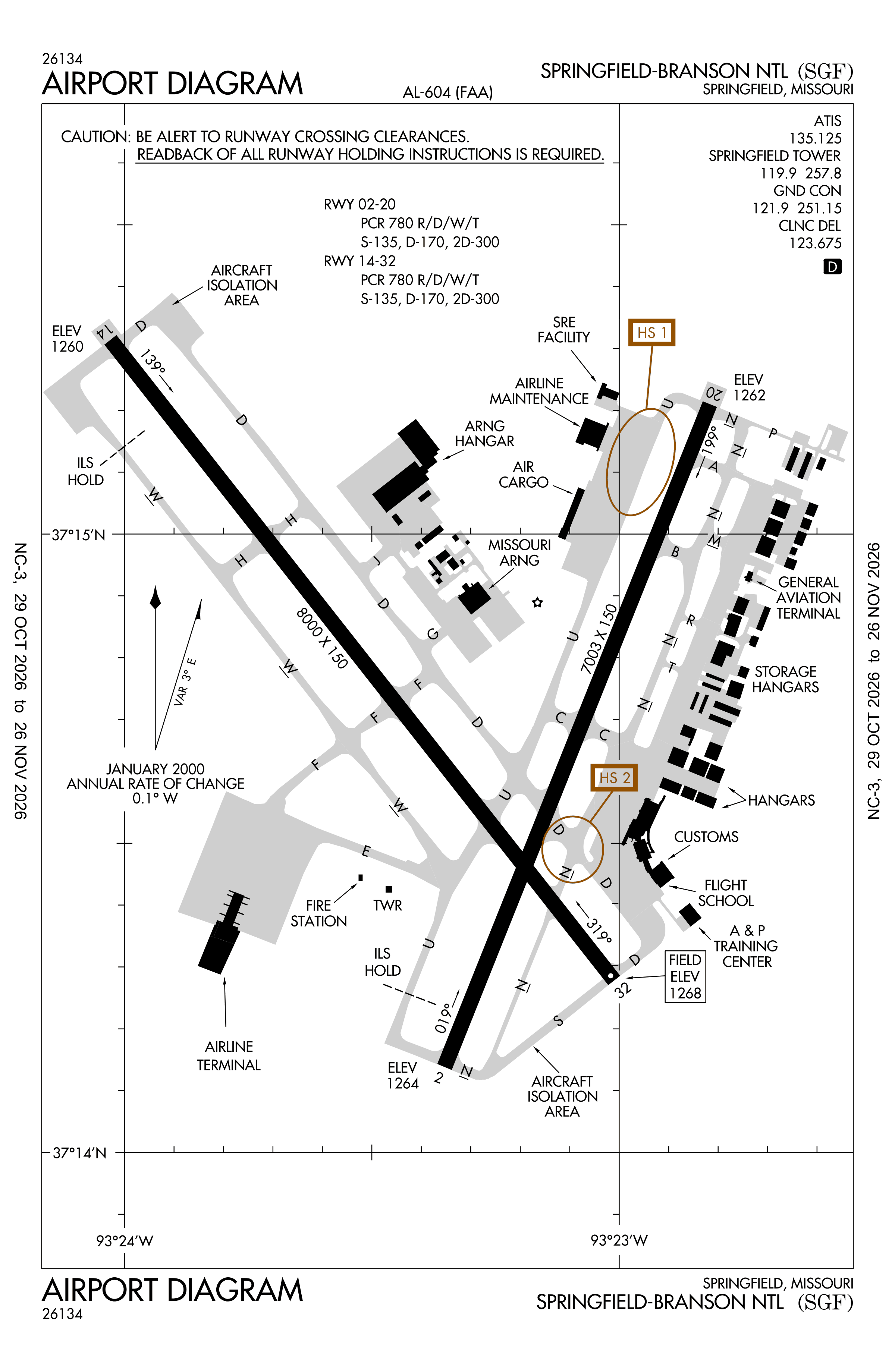
Redrawn by cwsi.net from the FAA airport diagram, cycle 2611, effective Oct 29 to Nov 26, 2026, and OpenStreetMap. Reference only, not for navigation.
FBOs and services
Related
- Interactive NOTAM search for KSGF (category filters, maps, share links and a NOTAM decoder)
- Springfield-Branson National Airport: codes, map and current weather
- SGF weather and runway winds (METAR and TAF in plain English)
- Flights at SGF now
- NOTAMs for other US airports
More NOTAMs in Missouri
Times are UTC (Z). Plain-English explanations are generated by cwsi.net from the NOTAM abbreviations and may simplify; the original NOTAM text is authoritative. NOTAMs come from the FAA NOTAM Management Service; cwsi.net refreshes its copy every 3 minutes. cwsi.net is not affiliated with the FAA: always confirm NOTAMs through official sources (a standard briefing or FAA NOTAM Search) before flight.