SBY NOTAMs
Salisbury-Ocean City Wicomico Regional Airport, Salisbury, MD · KSBY
Salisbury-Ocean City Wicomico Regional Airport in Salisbury, Maryland (IATA SBY, ICAO KSBY) has 25 current NOTAMs (Notices to Air Missions): 25 in effect now and 0 starting later. By category: runways (10), taxiways (8) and navaids (3). The list comes from the FAA NOTAM Management Service, refreshed by cwsi.net every few minutes; each NOTAM shows its number, category, start and end time in UTC, and a plain-English reading.
- Runway10
- Taxiway8
- Navaid3
- Procedures2
- Aerodrome1
- Obstacle1
In effect now (25)
TWY A5 SFC PAINTED HLDG PSN SIGNS FOR RWY 14/32 NOT STD 2611032148-2612042359
NAV TACAN AZM U/S 2611031743-2703312359EST
AD AP DIAGRAM INCORRECT TWY A 7600FT, TWY A6, A7 COMMISIONED SEE DOMESTIC NOTICE FOR CORRECTED AP DIAGRAM 2611021347-PERM
RWY 14/32 NW 1200FT CLSD. DECLARED DIST: RWY 14 TORA 6500FT TODA 6500FT ASDA 6500FT LDA 6500FT. RWY 32 TORA 6500FT TODA 6500FT ASDA 6500FT LDA 6500FT. 2611012332-2611260859
RWY 14 THR MARKINGS NOT STD 2611012041-2611272359
RWY 14 RWY END ID LGT U/S 2611020900-2611302359
RWY 14 ALL SFC MARKINGS NOT STD DUE TO CONST 2611012004-2611272359
RWY 14/32 NOW 6500FT X 100FT ASPH LGTD 2611011959-2611260859
TWY A NORTHWEST 400FT CLSD 2611011422-2611302359
TWY A1 CLSD LGTD AND BARRICADED 2611011421-2611302359
TWY A NOW 7600FT X 50FT ASPH LGTD 2610310900-2611260859
TWY A6 COMMISSIONED SOUTHEAST OF TWY A5 345FT X 50FT ASPH LGTD 2610310900-PERM
TWY A7 COMMISSIONED SOUTHEAST OF TWY A6 345FT X 50FT ASPH LGTD 2610310900-PERM
RWY 14 PAPI U/S 2611011630-2612012359
IAP SALISBURY-OCEAN CITY WICOMICO RGNL, SALISBURY, MD. ILS OR LOC RWY 32, AMDT 10... RNAV (GPS) RWY 14, AMDT 3... RNAV (GPS) RWY 23, AMDT 1D... RNAV (GPS) RWY 32, AMDT 4... RNAV (GPS) RWY 5, AMDT 2A... PROCEDURE NA. 2610291020-2706101020EST
ODP SALISBURY-OCEAN CITY WICOMICO RGNL, SALISBURY, MD. TAKEOFF MINIMUMS AND (OBSTACLE) DEPARTURE PROCEDURES AMDT 2... DEPARTURE PROCEDURE NA. ALL OTHER DATA REMAINS AS PUBLISHED. 2610290500-2810291346EST
OBST TOWER LGT (ASR 1204140) 381237.40N0754054.70W (11.4NM SW SBY) 346.5FT (331.4FT AGL) U/S 2610231741-2611302359
NAV ILS RWY 32 U/S 2610191413-2701152359EST
RWY 32 RWY ALL SFC MARKINGS NOT STD DUE TO CONST 2610070414-2611152359
RWY 32 PAPI U/S 2610070401-2611152359
TWY F CLSD EXC PERDUE AND FBO AND POLICE 1HR PPR 443-523-9503 2610070358-2611302359
RWY 32 ALS U/S 2610010024-2701152359
RWY 32 RAI LGT U/S 2609291720-2701152359
TWY A5 RUNUP PAD FOR RWY 32 CLSD 2604271000-PERM
NAV ILS RWY 32 GP U/S 2602151118-2611062000EST
Airport diagram
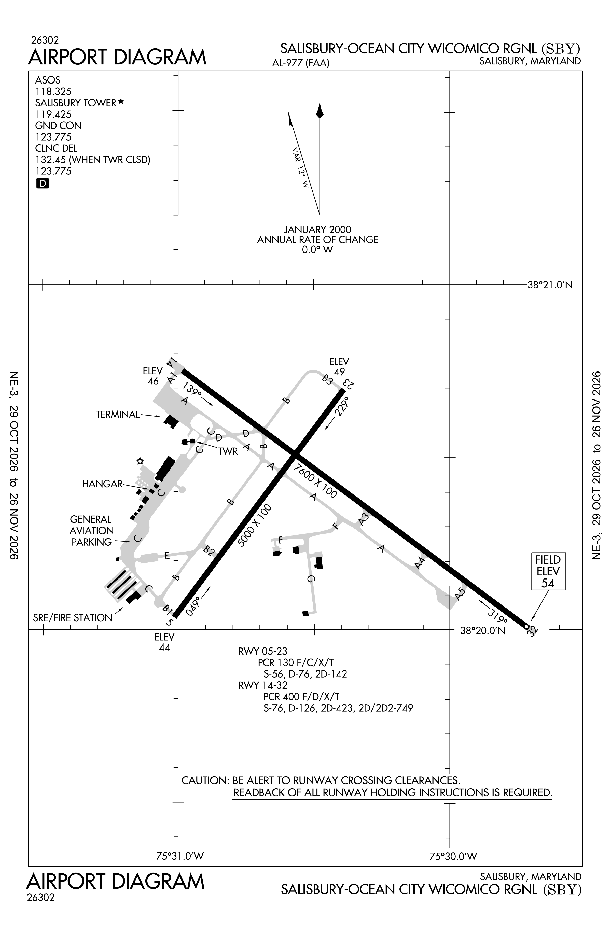
Official FAA PDF (effective Oct 29 to Nov 26)
FAA airport diagram, cycle 2611, effective Oct 29 to Nov 26, 2026. Reference only, not for navigation.
FBOs and services
FBOs
- Bayland Aviation FBO
FBO locations from OpenStreetMap, community-maintained and may be out of date. Call ahead to confirm services and hours.
Not listed? The FBO may not be in OpenStreetMap. Send a correction.
Data © OpenStreetMap contributors (ODbL), as of Nov 3, 2026.
Related
- Interactive NOTAM search for KSBY (category filters, maps, share links and a NOTAM decoder)
- Salisbury-Ocean City Wicomico Regional Airport: codes, map and current weather
- SBY weather and runway winds (METAR and TAF in plain English)
- Flights at SBY now
- NOTAMs for other US airports
More NOTAMs in Maryland
Times are UTC (Z). Plain-English explanations are generated by cwsi.net from the NOTAM abbreviations and may simplify; the original NOTAM text is authoritative. NOTAMs come from the FAA NOTAM Management Service; cwsi.net refreshes its copy every 3 minutes. cwsi.net is not affiliated with the FAA: always confirm NOTAMs through official sources (a standard briefing or FAA NOTAM Search) before flight.